Whangarei flood detention dam investment pays off; NRC
24 Jul 2020, 1:58 PM
An $11 million-plus investment in a Whangarei detention dam commissioned four years ago has begun paying off with the likely damage it spared the city’s central business district during the recent storm.
The Northland Regional Council says the Hopua te Nihotetea dam had faced its single biggest test during the wild weather, rapidly capturing 400,000 cubic metres of floodwaters from the Raumanga Stream that otherwise would have swept through the city’s CBD and parts of Morningside and Raumanga.
While flooding had obviously still impacted the central city, NRC Chair Penny Smart says Hopua te Nihotetea had performed flawlessly and without it “we would have expected much more significant river flooding in the Whangarei CBD”.
Other local authority works in recent years – including a more than 100-metre long flood wall built in Woods Rd last year and 2014 improvements to free up flows beneath a Rust Ave bridge – had also meant that collectively flooding and other damage had been greatly reduced or in some cases, avoided altogether.
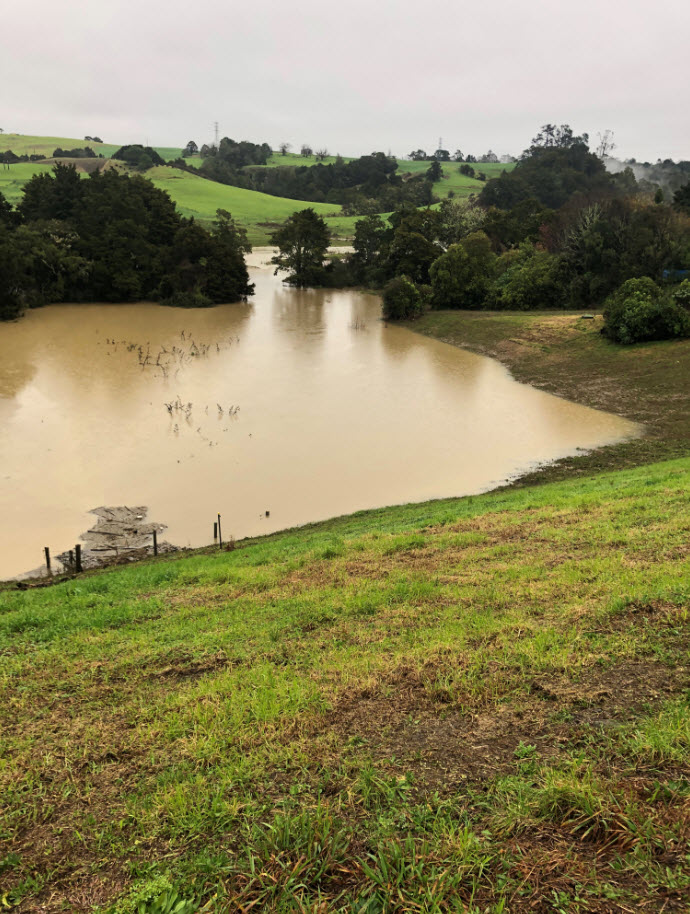 Whangarei’s Hopua te Nihotetea dam was already dropping by the time this photograph was taken on Saturday 18 July, but this image still gives an idea of the volume of Raumanga Stream floodwaters it held in check during the recent downpours.
Chair Smart says at its peak the Hopua te Nihotetea dam had retained about 400,000 cu m of floodwaters – still roughly only a third of its massive 1.3 million cu m capacity – with council engineers estimating this had held the flow in the Raumanga to a flow of about 82 cu m per second.
“That’s equivalent to the sort of level you’d expect to see roughly once every 27 years on average.”
The council’s Deputy CEO Bruce Howse, says without the dam, the council estimated the flow rate would have been much higher; 114 cu m per second and equivalent to the sort of level that would normally only be seen every 90 years.
In comparison, river flows recorded during recent storm in the Waiarohia Stream (at Lovers Lane near the Whangarei Library) were the highest flow on record, peaking at 113 cu m per second at 9pm Friday 17 July; again, the sort of flood levels that would normally only be seen every 90 years.
Mr Howse says it’s important to remember that Hopua te Nihotetea is not designed to completely stop the CBD from flooding as it only holds water from the Raumanga Stream and two more waterways – the Waiarohia Stream and tidal Hatea River – also flow into the downtown area.
“But in floods, much of the harm depends not only on how deep floodwaters are but crucially, how fast they’re travelling.”
The council says this is where the dam’s role is critical, as in a very large storm it significantly slows damaging floodwaters (releasing them gradually over several days instead) which can potentially cut flood depths in the CBD by up to half a metre.
Mr Howse says given the dam’s extremely long operational life (which could run to a century or more) it had been previously estimated it would effectively spare the city about $1.4 million in flood damage when averaged out annually over its lifespan.
“It’s probably fair to say that it has made a great start towards paying for itself just in terms of the likely damage it prevented over the recent storm alone.”
Mr Howse says the dam straddles the borders of Raumanga and Maunu and while it has an 18-metre high face (or ‘working height’) the volume of water held in a storage area in the valley that drops down behind is considerable.
“For the technically-minded, the dam level reached 58.19 metres at 10.50pm on 17 July. The dam invert (bottom of the dam) is 49m so this represents 9.2m of head measured against its 18m working height.”
(For comparison, the previously biggest test the dam had faced had come in June two years ago when floodwaters had reached about 5m of the 18m working height.)
As a detention dam (as opposed to a water storage dam like the one at Whangarei’s Whau Valley), for the vast majority of the time Hopua te Nihotetea actually holds no water at all, really only coming into its own in big storms.
The dam is being paid for via a targeted rate on more than 17,000 properties in the Whangarei CBD and contributing catchment areas.
It took about 16 months to build and at the time was the largest project of its kind undertaken by the regional council.
Meanwhile, the regional council is also asking the public for its help as it attempts to learn from the recent weather to design better flood protection infrastructure, create more accurate flood maps and inform Civil Defence responses.
Mr Howse says people are being asked to submit their photos of the recent flooding to help improve the council’s predictive computer models.
“Particularly useful are photos showing high water marks left by flooding and lines of debris or other indications of flood levels, like grass caught on power poles or fences. Photos of floodwaters at their peak are also useful.”
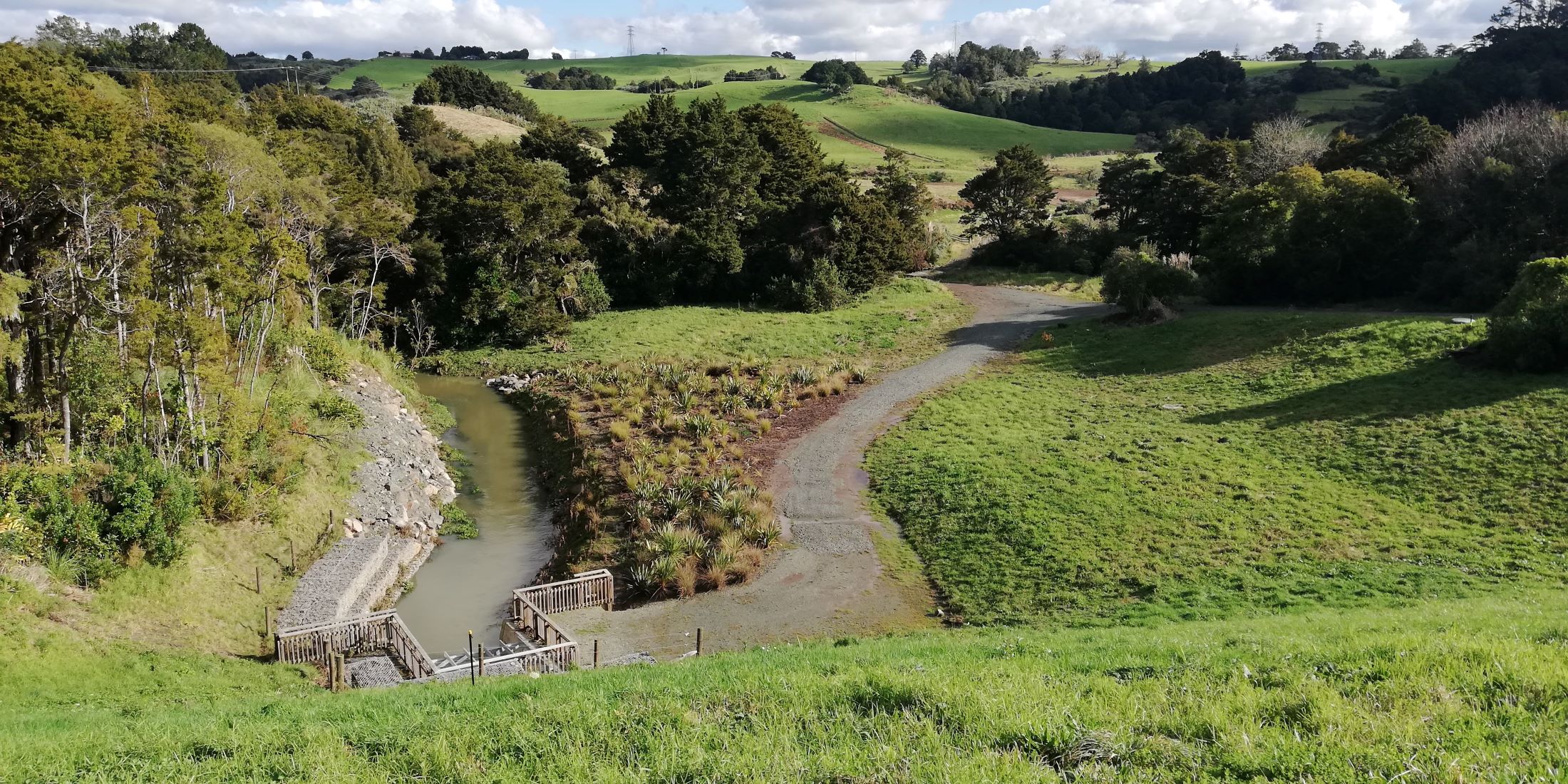
A file shot from mid-2018 showing what the area behind the Hopua te Nihotetea dam usually looks like.