Pest plants and animals
As an island nation, New Zealand is vulnerable to invasive species. This is because the country relies heavily on international freight transport, which can act as pest pathways and our native flora and fauna have evolved largely in isolation without the predation and competition effects of invasive species from other parts of the world.
Northland is particularly vulnerable given that the region has some of the warmest land and sea temperatures in New Zealand, as well as high levels of sunshine and sub-tropical weather patterns. This makes for excellent establishing grounds for new exotic pests. Pest species that originate from warm climatic environments have the advantage of similar weather conditions, low levels of frost, and very low levels of natural predators to deal with. Northland's forests are also botanically diverse and contain a high number of threatened plants and animals, which are sensitive to the impacts of pest species.
Invasive pest species have the potential to significantly impact on our environment, economy, health and our social and cultural well-being. These impacts can occur through loss of biodiversity, reduced production and impacts on amenity and cultural resources.
What are the main pest species in Northland?
Pest plants
Hundreds of weeds thrive in Northland's warm climate. However, to become a pest plant, a weed must also represent a threat to the region because of its ability to invade or take over land that is productive or has important ecological or cultural values (Table 10).
Pest plants can be given scores that give an indication of the plant's relative significance, such as biological success and weediness ratings (Esler et al.: 1993; Owen et al.: 1996). Biological success ratings are associated with the plant's ability to establish and spread, while weediness refers to the nuisance value of the plant. For example, high scores in both would make a plant high priority for management as it could easily spread and establish in new areas and cause significant impacts.
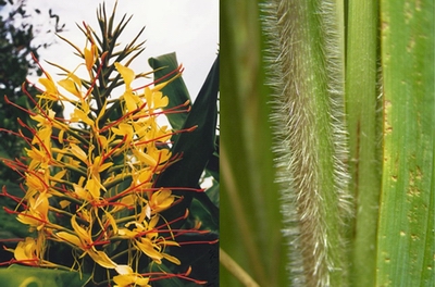 Wild ginger (left) and African feather grass (right) are just two invasive pest plant species found in Northland.
For more information about pest plants go to www.nrc.govt.nz/pestcontrolhub
Table 10: Impacts of some of the main pest plants in Northland
| Pest plant | Problems caused |
| Kahili (wild) ginger | Kahili ginger forms dense stands in native bush, on road sides and river banks, smothering and eventually replacing all other species. |
| Manchurian wild rice | Manchurian wild rice is a tall perennial grass that grows up to 3m tall. It forms dense stands in aquatic or semi-terrestrial situations, and can block drains, cause flooding and invade pasture. |
| Giant reed | Giant reed is a clump-forming, bamboo-like grass. It grows in dry and wet areas, forming dense stands, and can block streams and drains causing flooding, and displacing other vegetation. |
| African feather grass | African feather grass is a perennial grass that forms large clumps. It invades coastal dune areas, pasture, roadsides and reserves, and can completely suppress all other low-growing plants. |
| Pampas | Pampas is a perennial tussock-like grass, and is widespread in Northland. It invades dunelands, exotic forests, quarries, roadsides and disturbed native forests. It forms dense stands, excludes other vegetation, and provides habitat for animal pests. |
| Climbing asparagus | Climbing asparagus forms dense patches on the ground or sub-canopy in most forest types. It smothers other plants, and carpets the forest floor preventing the growth of native seedlings. It is fast growing and rapidly colonises new areas. |
| Moth plant | Moth plant is an evergreen vine that grows to 10m tall. It is long-lived, fast-growing and shade-tolerant, forming dense, heavy, smothering masses that overtop and strangle supporting plants. It invades intact or disturbed forest and is poisonous. |
| Taiwan cherry | Taiwan cherry is a deciduous tree growing to 8m tall, and has commonly been planted in gardens. Seeds are dispersed by birds, and naturalised populations are now present in bush areas in Northland, where it crowds out native plants. |
| Elaeagnus | Elaeagnus is a long-lived, vigorous scrambling vine. It forms a dense blanket smothering native species up to mid-canopy level. It is a problem in forest interiors and can prevent access into recreational areas. |
| Woolly nightshade | Woolly nightshade is a spreading shrub that grows to 10m. It forms dense, often pure stands, and inhibits or prevents the establishment of native plant seedlings. It also invades pastures, and may be poisonous to livestock. |
| Privet | Privet is any one of four species of evergreen shrubs or trees. It inhabits bush, gardens, roadsides and ungrazed wasteland areas. It prevents native plant regeneration and can completely dominate areas of bush. It can contribute to respiratory disorders and is toxic to livestock. |
| Lantana | Lantana forms dense impenetrable thickets, and invades bush edges, pasture, roadsides and wasteland, where it replaces all other vegetation. It is poisonous to stock and humans. |
Pest animals
Northland has a number of animal and insect species that are considered pests. Many of them have been present in New Zealand for a considerable period of time, and their impacts affect the regional economy, environment and culture (Table 11).
Table 11: Impacts of some of the main pest animals in Northland
| Pest animal | Problems caused |
| Argentine ants | Argentine ants are often present near sites of human habitation throughout Northland. They impact native invertebrate species through predation and competition. These ants are a domestic nuisance, swarming over food and infesting gardens, and can cause significant costs to the horticulture and agriculture industries. |
| Feral cats | Feral cats are widespread throughout Northland and live in most terrestrial habitats. Cats kill millions of birds in New Zealand each year, as well as eating eggs, lizards, insects and frogs. They can also spread parasites and diseases such as bovine tuberculosis (Tb) and toxoplasmosis. |
| Feral deer | There are four species of feral deer in Northland, but none are widespread or numerous. Deer can destroy the understorey of native forest by over browsing, grazing, bark stripping and trampling. Feral deer can also damage crops and exotic forests and can transmit bovine Tb. |
| Feral goats | Feral goats are widespread throughout Northland. Populations are generally dense in areas of exotic and native forest, as well as in areas of poor pasture/scrub. Goats destroy the understorey of vegetation, and when combined with possum damage to the upper canopy, severe deterioration of the forest can occur. Goats can also cause erosion problems. |
| Mustelids (ferrets, weasels and stoats) | Mustelids are widespread throughout Northland. They can be devastating to native birds, lizards, frogs and invertebrates. Mustelids can also spread parasites and diseases such as bovine Tb and toxoplasmosis. |
| Possum | Possums are found throughout the region, and are one of the most destructive animals in forests. Possum browsing damages forests, affects pasture, vegetable and horticulture crops. Possums can also spread diseases such as bovine Tb. |
| Rabbit | Rabbits are widespread throughout Northland. Infestation levels vary, with greatest densities on hard-grazed lighter and drier sandy and volcanic soils. Rabbits compete with stock for grazing, damage crops and can cause erosion. |
| Rats | Rats are widespread throughout Northland. They are mainly nocturnal, and eat seeds, bird eggs, nestlings, invertebrates, frogs and lizards. They have a significant impact on native plants and animals, and also eat and contaminate grain and food stores. |
What is being done?
Pest management strategies
The Northland Regional Pest Management Strategies 2010-2015 include 100 terrestrial plant pests and 35 terrestrial animal pests, of concern to the Northland region (Northland Regional Council: 2010). A much higher number of pest species in the current strategies are of considerable concern for biodiversity values than for agriculture or horticulture, as is the trend for most regions of New Zealand.
The pests fall under different classifications in the strategies, depending on whether they are established in the region and how widespread they are. The classification of the pest helps guide the strategies' objectives, operational plans and management programmes for each pest.
During 2010/11, 20 new operational plans were developed for the terrestrial pests in the strategies. Each plan covers the five-year period of the strategies and includes clear links between outcomes defined in the Long Term Plan, the Regional Pest Management Strategies and the operational plans. Indicators and measures of performance are defined and are used to gauge programme progress, guide programme improvements and report performance clearly and effectively.
The objectives of the programmes and the management methods vary depending on the pest species and its classification in the strategies, but are either species-led or site-led. The main pest management methods can include education, surveillance, community programmes, occupier control, biological control and council response.
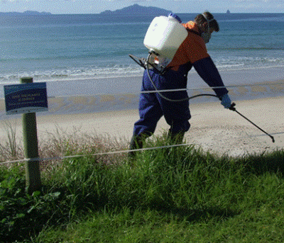 Spraying dune weeds at Waipū Cove.
Public awareness
A key aim for the council is to raise public awareness of terrestrial pests by providing information about the pests, their impacts, dispersal and management options through publicity campaigns, publications, events and providing an advice and identification service.
The number of biosecurity enquiries received by the council has increased from approximately 850 in 2007 to more than 1100 in 2011. The council also provides pest control products to customers on a non-profit basis, to assist with animal pest control (for example, possum and rat bait). This service encourages greater public participation in animal pest control and the council currently sells over $50,000 worth of materials each year and provides information to customers regarding best practice pest control methods.
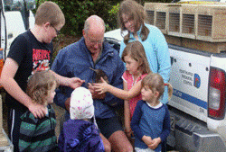
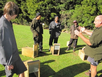 Project possum training day – an initiative that teaches secondary school pupils about possum control and plucking the fur to sell.
Biocontrol
Biocontrol (biological control) is the use of naturally occurring enemies and diseases to control pests and weeds. Biocontrol will not totally eradicate a species but aims to suppress populations to low levels. It is the most cost effective method of pest control over a wide area and at remote sites. Once sustainable populations have established and become widespread the biocontrol agents carry on working against the target pest indefinitely.
Biocontrol agents have been introduced to Northland to control pests such as gorse, ragwort, thistles, broom, alligator weed, mist flower, buddleia, Mexican devil weed, St John's wort and boneseed. There are currently nearly 100 species of biocontrol agents in Northland. These include 28 species (including five diseases) of weed biocontrol agents, and more than 30 insect biocontrol agents, including earwigs, lacewings, hoverflies, nabid and pentatomid predatory bugs, numerous parasitoid wasps of aphids, mealybugs, thrips, and scale. There are also 10 species of exotic predatory ladybird and two native species of predatory ladybird, and at least seven species of predatory mites.
A total of $50,000 a year is invested in Northland's biocontrol and a national collective of 13 regional councils and the Department of Conservation provide approximately $670,000 annually toward a national biocontrol programme. The programme is managed by Landcare Research and provides research, quarantine facilities and management of releases of the agents which target plant and insect pests within New Zealand.
 Mexican devil weed gall fly – a biocontrol agent.
Species-led programme – Manchurian wild rice
In Northland, Manchurian wild rice covers approximately 500 hectares. It is widespread in the Kaipara district, with the main infestation found next to the Northern Wairoa River and its tributaries. There are also a small number of sites in Whāngārei, Kerikeri, and Mangakāhia. Manchurian wild rice is a tall perennial grass that grows up to 3m tall in aquatic or semi-terrestrial habitats, blocking drains, causing flooding and invading pasture.
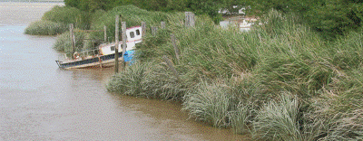 Manchurian wild rice on the banks of the Wairoa River.
The council is working with the Ministry for Primary Industries to ensure the containment, reduction and eventual eradication of Manchurian wild rice within Northland. The council manages the programme in Northland and has received funding between $240,000 and $320,000 annually from the ministry since 2008. Initially, the programme has focussed mainly on eradication of outlier sites, those sites not connected to the main infestation area which adjoins the margins of the Northern Wairoa River.
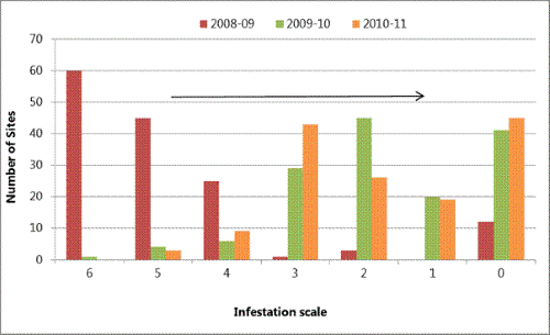
Infested sites require repeated spraying and a programme of sustained control is necessary for eradication of the plant at each site. Sites which have been under an active control programme for three years or more are showing a decline in the number of plants and percentage ground cover and there are more sites with only scattered juvenile plants or none at all ( Figure 46).
Figure 46: Manchurian wild rice density levels 2008-2011
Species-led programme - Lantana
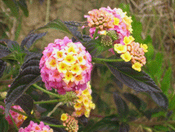 Lantana.
Lantana is a major weed of both natural and agricultural ecosystems overseas, and forms dense impenetrable thickets, invading bush edges, pasture, roadsides and wasteland. It is found throughout Northland with the heaviest infestations located near old settlement areas in the Hokianga and near Whangaroa. The 2010-2015 operational plan aims to remove the threat of lantana to areas of high ecological significance and to reduce the impacts of the plant throughout the wider region, by controlling sites outside the main infestation areas.
There are on-going programmes in Northland to increase awareness of the problems caused by this species; to support research into biocontrol; and to encourage community control. The council-funded control programme is systematically locating and eradicating outlier sites of lantana from the North Cape down the Aupōuri Peninsula, and from the Bream Bay area. Controls of other small outlying infestations located throughout Northland, are also occurring.
Control requires site inspections and spraying for several years to ensure that no viable seeds remain in the soil. The Far North control programme is currently ahead of schedule, with all sites in the stage 1 area now controlled and site surveys and control work extending well into the stage 2-4 zones.
A project to introduce two new rust species as biocontrol agents for lantana was also launched during 2011 with Landcare Research and culminated in importation of the rusts being approved by the Environmental Protection Agency during 2012.
Species-led programme – Feral deer
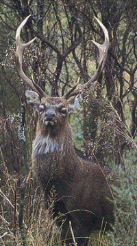 Feral deer – a rare sight in Northland since the implementation of a joint agency deer response team in 1997.
Feral deer are listed as an eradication species in the Regional Pest Management Strategies and rules aimed at preventing their importation and illegal release are in place. Feral deer are not common in Northland but if left uncontrolled would spread to occupy all available habitats, and damage Northland's unique native forests.
Farming communities are also justifiably concerned as feral deer have been confirmed as an efficient vector of bovine Tb to domestic animals. Feral deer are the main, if not only, vector of Tb transmission to possums (Lugton et al.: 1997). Northland is currently free of bovine Tb however, the economic costs of deer to Northland should Tb become established in feral deer herds and other wildlife, could balloon out to $6 million per annum (Sweetapple: 2006). A joint agency deer response team, funded by the council, Department of Conservation and the Animal Health Board, was established in Northland in 1997 in response to increasing feral deer populations, and associated impacts (Fraser et al.: 1996). The programme aims to remove all feral deer populations, and halt their dispersal through reducing the risk of farm escapes (McKenzie: 1996).
When the programme began in 1997 more than 140 wild deer in five separate herds were established in Northland. By 2007 all red, fallow and wapiti herds had been eliminated and the sika herd had been reduced to very low population levels. Since 2007, the sika herd has been targeted and no remaining individuals are known to exist, however further survey and time is required to confirm eradication. Unfortunately illegal liberations of a small number of fallow and sika deer have occurred in 2012 and these herds are targeted for eradication by the response team.
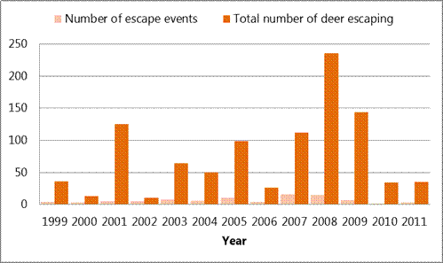
Deer escapes from farms are common, occurring at an average rate of 6.5 escape events per annum since 1999 (Figure 47). All deer known to have escaped from farms between 2007 and 2011 have been either shot or recaptured so that no further wild herds have established. The cause of escapes is related to stock management, lack of fence maintenance, damage to the fence caused by storm weather events or simply leaving a gate open. Once deer escape from a farm they are easily frightened, becoming wary and extremely difficult to recapture. These deer quickly revert to a wild state. Responding to these escapes and preventing the establishment of wild herds is a key role of the response team.
Figure 47: Recorded farm deer escapes from 1999-2011
Site-led projects
Community projects which target multiple pest species are increasingly popular and by December 2011 regional council staff had helped set up 39 community plans – 21 in the last five years – involving more than 830 people, and 38,000 hectares of land. Community plans are used to help support the protection of kiwi, brown teal and other endangered fauna as well as deliver pest ant and weed control. The majority of the Community Pest Control Areas target multiple pest species.
Community Pest Control Areas targeting possums are monitored at regular intervals and communities are required to keep possums below agreed levels. Wax tag monitoring is a standardised way of estimating possum abundance and is measured by recording the proportion of possum bite marks on tags over randomly located lines. Wax tag indices in Northland prior to possum control were consistently recorded at more than 30% and had reached peaks of more than 70% in some habitats.
Wax tag monitoring is completed annually in a selection of the Community Pest Control Areas with up to 100 lines spread over 10 to 20 different areas in a year. In the last five years, only one of the 39 Community Pest Control Areas has consistently failed to meet targets for possum control. Although results have varied between areas and years, average results across those monitored have consistently shown possum numbers averaging 6% per year (range 0-24%).
Low possum populations can be assumed when wax tag interference levels are below 10% or less. General improvement in the forest canopy, flowering and fruiting of certain plant species such as kohekohe can be attributed to control of possums to these low levels (Nugent et al.: 2002).
Case study: Purerua Peninsula
 Baby kiwi are vulnerable to animal pests, especially uncontrolled dogs, stoats and cats.
Landowners on Purerua Peninsula and the northern entrance to the Bay of Islands have been actively managing predators of kiwi and the endangered Pāteke or brown teal for over a decade. Supported by the Northland Regional Council and the NZ Kiwi Foundation, a charitable trust set up for the restoration of kiwi, landowners have been successful at restoring brown teal and enhancing kiwi populations over more than 3000 hectares of farmland, forestry and native forest.
Pest control at this large landscape-scale provides the best opportunity for juvenile Pāteke to survive as they disperse many kilometres from their breeding sites where they are vulnerable to cats and stoats. Kiwi also benefit from pest control undertaken over several thousand hectares as the frequency and impact of predator reinvasion on the core kiwi breeding areas is reduced while providing additional pest free habitat for their offspring.
Trapping the killers of kiwi and Pāteke is a major focus of the project and results collected since 2008 show a 56% decline in the number of cats caught per month and monthly catch levels for stoats of less than 0.4, indicating that population densities are low. Over 1500 stoat traps and 330 wild cat traps are in place and a zero tolerance policy for wandering or stray dogs is in force. This means uncontrolled dogs are destroyed on sight as they are known to have a severe impact on ground dwelling birds like kiwi and Pāteke as well as preying on livestock.
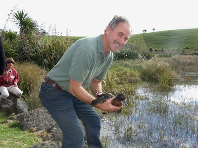 Northland Regional Councillor Joe Carr reintroduces Pāteke to boost populations at Purerua.
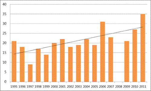
Figure 48: Mean number of kiwi calls recorded at Marsden Cross, Purerua 1995-2011
Northland's Top Wetlands Project
The purpose of this project is to identify, document and promote the protection and better management of significant indigenous wetlands in Northland. The first part of the project identified over 300 of Northland's best wetlands and ranked them into groups by ecological district and wetland type. From this list the top ranked 150 wetlands in Northland have been identified.
Landowners with land adjoining any of the top 150 wetlands will be contacted to explain the intentions of the project and provide information specific to their wetland as well as offering advice on managing the wetland and possible assistance. The project has also developed guidelines to help with the identification of indigenous wetlands and guidelines for their management, specific to each wetland type. For more information about the project go to: www.nrc.govt.nz/wetlands
Legal protection and designation
In total, 13.75% of Northland's terrestrial area has some form of legal protection. This equates to 2067 areas covering a total of 180,336ha (Wildlands report No. 1844). Of this total, 1905 areas covering 156,451ha (around 92% of the total area) are protected with the aim of conserving natural values. The remainder of the areas may protect natural values as a by-product of protection but that is not the purpose of the reserve or protected area. So the total amount of Protected Natural Areas comprises around 11% of the total of Northland's land area. If Protected Natural Areas are not in Department of Conservation estate or embodied in district/regional plans, they may have no protection.
Department of Conservation
The agency with both the greatest number of Protected Natural Areas and the largest area is the Department of Conservation: 144,089ha in 802 sites which equates to 92% of the area covered by Protected Natural Areas. Areas managed by the Department of Conservation are classified into a range of different reserve types and are managed under a number of different acts of parliament.
QEII National Trust
The Queen Elizabeth the Second (QEII) National Trust Act provides a legal mechanism to secure the protection of biodiversity on private land through the creation of an open space covenant. An open space covenant is a legally binding agreement between the landowner and the Trust to maintain an area as open space in perpetuity.
At June 2011, Northland had 578 registered QEII National Trust Open Covenants and a further 51 approved, as shown in Table 12. The total land area in registered and approved covenants was 9570 hectares. The largest covenant is 417ha. However, most covenants in Northland are small, with an average size of 15ha. Northland has the largest number of registered covenants of all the regions in New Zealand but the average size is the smallest. Of the 16 regional councils and unitary authorities, Northland ranks fifth in terms of total area covenanted, and in terms of percentage of total area protected with QEII covenants, it is third (0.76% of total area).
Table 12: Number and area of QEII covenants in Northland as of August 2007
| 2007 Covenants | 2011 Covenants | |||||
| Approved | Registered | Total | Approved | Registered | Total | |
| Total number for Northland | 92 | 442 | 534 | 51 | 578 | 629 |
| Total area for Northland (ha) | 1552 | 6561 | 8113 | 9570 | ||
| Average size for Northland (ha) | 16.7 | 14.8 | 15.2 | 15.2 | ||
Whāngārei District Council
The Whāngārei District Council has a process whereby conservation covenants can be established on private property under the Reserves Act (1977). As at 2010 there were 346 conservation covenants broken into 799 parts covering a total of 1185ha. Average covenant size is 1.5ha and the largest is 58ha.
Nga Whenua Rahui
Māori landowners can protect their indigenous ecosystems under Nga Whenua Rahui kawenata. The agreement is sensitive to Māori values in terms of spirituality and tikanga. Cultural use of these natural areas is blended with the acceptance of public access within the agreements. The objective is long-term protection with inter-generational reviews of conditions.
As at April 2008 there were 15 Nga Whenua Rahui kawenata in Northland covering a total of 3509ha.
Working with other agencies
Biodiversity Northland (formerly Northland Biodiversity Enhancement Group) was formed in 2001 and was New Zealand's first regional biodiversity forum. It is convened by the NZ Landcare Trust and its partners are organisations and agencies with a role in biodiversity protection in Northland. These include Northland Regional Council, Department of Conservation, NZ Landcare trust, district councils, Queen Elizabeth II National Trust, BNZ Save the Kiwi, Fish and Game New Zealand and the Farm Forestry Association.
Biodiversity Northland increases the level of co-operation between the various groups and encourages a strategic interagency approach. Projects to date include development of a landowner self-help kit Restoring the Balance, a regular biodiversity display at the Northland Agricultural Field days, workshops on different biodiversity related topics and the Whole of Northland Project.
Northland Regional Council Environment Fund
The council's Environment Fund is a contestable fund that was established to assist landowners and community groups to carry out work that has wider environmental benefits for the community. The fund will meet up to 50% of the cost of approved projects in recognition of the fact that environmental protection work carried out on private land has benefits to the wider community. Types of projects funded include fencing of wetlands and waterways, excluding stock from coastal areas, dune protection and restoration and pest control.
For a number of projects additional funding has been obtained from the Department of Conservation Biodiversity Condition Fund. Other projects have been jointly funded with Queen Elizabeth II National Trust where the landowner is covenanting the land.
How are we measuring up against our objectives?
The following are the anticipated environmental results for terrestrial biodiversity and biosecurity management in the operative Regional Policy Statement for Northland:
An increase in the areas of significant indigenous vegetation and the significant habitats of indigenous fauna which are formally protected
• Of the 416,900ha of indigenous vegetation land cover recorded in Northland in 2002 (33% of the total land area of Northland – approximately 1.25 million hectares), 150,084ha had some form of legal protection. This equates to 12% of the total land area in Northland. In 2012, a total of 180,336ha was recorded as legally protected. This equates to 14.4% of Northland's total land area, suggesting that this environmental result is being achieved.
No increase in the number of threatened species in the region
• In 2004 there were 179 threatened plant species recorded in Northland, and in 2009 there were 241. The increase in number is attributed to several factors including improved knowledge of plant distributions stemming from dedicated survey, taxonomic resolution of long-established tag-named entities, the discovery of novel plants, and the loss of key habitat types through changes in land use practices over the last decade (Forester and Townsend: 2004; de Lange et al.: 2009).
Reduction in the damage caused to soils and natural features from pests and noxious plants
• In 1997 it was estimated that there were more than 140 wild deer in five separate populations in Northland. Although these numbers were low there was the potential for a rapid increase in numbers and consequently in the damage that they would do. A joint council, Department of Conservation and Animal Health Board operation led to the total removal of these wild populations, while on-going work ensures any new escapes from deer farms are either recaptured or killed. Feral deer can be very damaging to indigenous forest. By removing much of the understory they stop regeneration and increase the likelihood of soil erosion.
• The council works with a number of local communities in joint pest control operations where the community has identified particular pest animals or pest plants that are a concern to the communities. To date 39 community pest plans have been developed, often targeting multiple species. Included are intensive operations targeting feral goat populations, which impact upon forest health and can lead to an increase in erosion, and possum control operations on possums that are damaging coastal pohutukawa forest, an iconic natural feature of Northland.
References
Ausseil, A., Gerbeaux, P., Chadderton, L., Stephens, T., Brown, D. and Leathwick, J. (2008). Wetland ecosystems of national importance for biodiversity: Criteria, methods and candidate list of nationally important wetlands. Landcare Research Contract Report: LC0708/158.
Conning L. (2001). Northland Protection Strategy. A Report to the Nature Heritage Fund Committee. Published by the Nature Heritage Fund, Wellington, New Zealand.
Craig.E, Gardiner C., Renwick N., Sporle W. (2011). Taxon Plan for Northland Brown Kiwi. Department of Conservation. 2011. Department of Conservation Publication.
Craig E., 2012. Call count monitoring of Northland brown kiwi (2011). Department of Conservation. Department of Conservation Publication.
Forester, L. and Townsend, A. (2004). Threatened plants of Northland Conservancy. Department of Conservation.
Fraser K. W. (2005). Wild deer in Northland: Modelling potential new populations and the extant Russell population. Landcare Research Contract Report LC0506/053.
Lugton I. W., Wobeser G., Morris R. S., Caley P. Epidemiology of Mycobacterium bovis infection in feral ferrets (Mustela furo) in New Zealand: II. Routes of infection and excretion. New Zealand Veterinary Journal 45, 151–7, 1997.
Mckenzie D. S. (1996). Wild deer in Northland. A proposal to eradicate feral populations and reduce the risk of farm escapes. Unpublished. Department of Conservation Report, p12.
McLennan, J. A., Potter M. A., Robertson H. A., Wake G. C., Colbourne R., Dew L., Joyce L., McCann A. J., Miles J., Miller P. J., Reid J. (1996). Role of predation in the decline of Kiwi Apteryx Spp. in New Zealand. New Zealand Journal of Ecology Vol. 20, No.1, 1996.
Nugent G.; Whitford J.; Innes J.; Prime K. (2002). Rapid recovery of kohekohe (Dysoxylum spectabile) following possum control. New Zealand Journal of Ecology, Vol. 26, No. 1, 2002.
Sweetapple P. J. (2006). Costs of deer to Northland. Landcare Research Contract Report LC0607/060. Prepared for Northland Regional Council, Whāngārei.
Van Meeuwen-Dijkgraaf (2008). Protected Natural Areas in Northland, and Care Standards for Protected Natural Areas. Wildlands Consultants Report No. 1844.