Biodiversity and biosecurity on land
Northland is a biodiversity hotspot. Many of the natural values and areas in the region are of international and national significance. They are often the last remaining ecosystems of their type in New Zealand or the world, and representative of the natural character of New Zealand, or they contain examples of values that are not protected elsewhere.
Northland has a wide range of pressures on biodiversity due to it being a narrow peninsula, and its warm climate and diversity of land uses include farming, forestry and horticulture. Forest clearance and the draining of wetlands was historically a major cause of biodiversity decline, with less than 5.5% of original freshwater wetlands remaining (the national average is 10%) and about 26% of original forest cover (Ausseil et al.: 2008; Conning: 2001). However, changing land management practices have reduced this pressure somewhat. The impact of introduced animal and plant pests on biodiversity is of major concern and this issue remains the key reason for continued biodiversity decline.
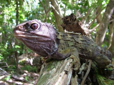 Tuatara, once widespread and abundant throughout Northland, are now restricted to near-shore island sanctuaries like the Poor Knights and Hen and Chick Islands.
What do we want for our terrestrial ecosystems?
The operative Regional Policy Statement for Northland states community objectives for managing significant natural and physical resources in our region. The objectives relating to terrestrial biodiversity and biosecurity management are:
• Maintenance of the biodiversity of the Northland region.
• Protection of the life-supporting capacity of ecosystems through avoiding, remedying or mitigating (in that order of priority) the adverse effects of activities, substances and introduced species on the functioning of natural ecosystems.
• Protection of areas of significant indigenous vegetation and the significant habitats of indigenous fauna.
• The avoidance, remedying or mitigation of the adverse effects of plant and animal pests on the use of land, including its potential for primary production and natural ecosystems.
The following are the anticipated environmental results for terrestrial biodiversity and biosecurity management in the Regional Policy Statement for Northland:
• An increase in the areas of significant indigenous vegetation and the significant habitats of indigenous fauna which are formally protected.
• No significant increase in the number of threatened species in the region.
• Reduction in the damage caused to soils and natural features from pests and noxious plants.
Note: the operative Regional Policy Statement is currently being reviewed. The proposed Regional Policy Statement (2013) is available at www.nrc.govt.nz/rps
What is our native land cover?
Northland's terrestrial area covers about 1,254,826 hectares with some 32% of this area (419,000ha) in indigenous vegetation (Table 8). Approximately 12% (150,579ha) is designated as protected natural areas, which means it has some form of legal protection (Van Meeuwen-Dijkgraaf: 2008). The Department of Conservation manages 92% of the area covered by protected natural areas however there are numerous other protected natural areas on private and other agency-managed lands.
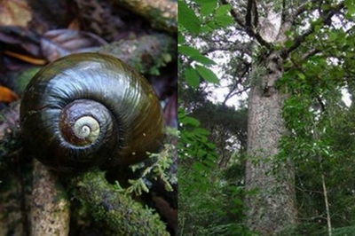 The kauri snail (left) is one of many threatened species found in Northland while the kauri forests at Waipoua (right) provide one of the finest examples of this forest type in the world.
Table 8: Estimated area of indigenous land cover in Northland in 1997 (Land Cover Database 1 - LCDB1) and 2002 (LCDB2) and 2007 (LCDB3) (Data source: Ministry for the Environment)
| Indigenous land cover class | Area (Hectares) | ||
| 1997 (LCDB1) |
2002 (LCDB2) |
2007 (LCDB3) |
|
| Broadleaved indigenous hardwoods | 18,176 | 17,710 | 19,721 |
| Depleted tussock grassland | 7 | 7 | 7 |
| Fernland | 76 | 57 | 149 |
| Flaxland | 168 | 168 | 144 |
| Grey scrub | 341 | 339 | 579 |
| Herbaceous freshwater vegetation | 7053 | 6993 | 8374 |
| Herbaceous saline vegetation | 3368 | 3368 | 3156 |
| Indigenous forest | 256,585 | 255,724 | 248,893 |
| Mangrove | 14,614 | 14,614 | 15,568 |
| Manuka and/or kanuka | 118,706 | 117,930 | 122,554 |
| Total native vegetation cover | 419,094 | 416,910 | 419,145 |
| Estuarine open water | 24,727 | 24,727 | 25,314 |
| Coastal sand and gravel | 16,217 | 16,163 | 14,573 |
| Lake and pond | 4140 | 4159 | 4115 |
| Landslide | 16 | 16 | 10 |
| River | 1968 | 1968 | 1964 |
| River/lakeshore gravel and rock | 34 | 34 | - |
| Total other native land cover | 47,103 | 47,068 | 45,976 |
| Total native land cover | 466,197 | 463,978 | 465,121 |
Note: Due to differences in the way that the data for LCDB1, LCDB2 and LCDB3 has been collected and interpreted and a certain amount of error contained within the data, it is difficult to directly compare the data between the different series. The information does however provide a good broad overview and suggests that the total area of indigenous vegetation in Northland has remained relatively stable.
What is the status of native species in Northland?
Northland is considered a "hotspot" for species diversity and local endemism, that is, species that are only found here. The region is the stronghold of the iconic North Island brown kiwi, rare native plants and forest fauna, including 293 terrestrial and freshwater native fauna species (Hitchmough, et al.: 2007). Of these, 225 are invertebrates, and 53 are acutely threatened, 13 are chronically threatened, and 160 are at risk. Of the remaining threatened taxa (birds, bats, freshwater fish, frogs and lizards), 16 are acutely threatened, 20 are chronically threatened, and 31 are at risk.
Native plants found in New Zealand total 2500 and 1200 are known from Northland, of which almost half are found nowhere else in the world. Of international significance are the Poor Knights and Three Kings islands, and the North Cape region, all of which contain many locally endemic, threatened species. Also of international significance are the unique kauri forests around Waipoua, which provide one of the finest examples of this forest type.
Many of Northland's threatened species occur in the most highly threatened ecosystems. Of particular concern are the increasing numbers of threatened species in Northland. In 2004 there were 179 threatened plants recorded in Northland, which had increased to 241 by 2009 (Forester and Townsend: 2004; de Lange et al.: 2009).
Table 9: Summary of threatened and at risk vascular plants in Northland
| Northland threatened plant summary | ||
| NZ threat status | Threat value | Count of species |
| At risk | Declining | 25 |
| At risk | Naturally uncommon | 99 |
| At risk | Relict | 18 |
| Data deficient | Data deficient | 14 |
| Native | Coloniser | 8 |
| Native | Extinct | 1 |
| Native | Vagrant | 8 |
| Threatened | Nationally critical | 35 |
| Threatened | Nationally endangered | 15 |
| Threatened | Nationally vulnerable | 18 |
Northland brown kiwi: a key indicator species
Information for the following section is largely taken from the report "Taxon Plan for Northland Brown Kiwi" (Craig et al.: 2011) and Call count monitoring of Northland brown kiwi 2011 (Craig: 2012). Northland is a stronghold for brown kiwi (Apteryx mantelli) as it contains around 32% of the total New Zealand population. There are around 8000 kiwi spread over 25 population clusters both on the mainland and offshore islands.
Kiwi in Northland have the highest productivity rate but also have the highest adult mortality rate, with an average life expectancy of only 14 years, largely due to predation by dogs. North Island kiwi had probably declined in abundance by at least 90% in the previous 100 years (McLennan et al.: 1996) resulting in the localised extinction from many areas.
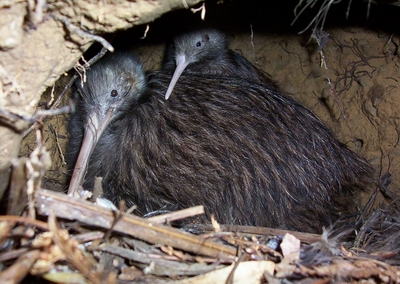 The presence and number of Northland brown kiwi are good indicators of the state of Northland's biodiversity (©P. Graham).
Figure 44: Department of Conservation map showing the approximate distribution of brown kiwi in Northland
The two major threats to kiwi in Northland are dogs, which kill kiwi at all stages of their life, and stoats – a major threat to juvinile kiwi. Kiwi also face predation and competition pressure from a range of other introduced species such as cats, ferrets, possums, rats, hedgehogs and pigs. Populations are also impacted by habitat loss and fragmentation.
Current management
Advocacy programmes have been in place since 1991 to raise awareness of the decline in kiwi populations. This work has led to increased public awareness of threats to kiwi and increased involvement in protection programmes. A number of agencies are involved in advocacy work including the Department of Conservation, Kiwis for kiwi, NZ Kiwi Foundation, NZ Landcare Trust, Queen Elizabeth II National Trust and the Whāngārei Native Bird Recovery Centre. The Whāngārei Kiwi Sanctuary was established with assistance from the 2000 NZ Biodiversity Funding Package. It comprises a mix of public and private land and covers 17,400 hectares, which are managed with the aim of enhancing the mainland population through intensive predator control.
Community groups are involved in active management of kiwi populations at approximately 34 sites in Northland. These projects are on a mix of private and public land and involve predator control and habitat restoration.
Kiwi call monitoring, BNZ operation nest egg, kiwi aversion training for dogs, research and mainland island and offshore island projects all contribute to the efforts underway in Northland.
Population trends
Figure 45: Trends in kiwi call count data 1995-2011 (Craig: 2012)
Trends in call count data collected since 1995 at the 24 original listening stations in the northern, eastern, western and southern survey areas are displayed in Figure 45.
Kiwi call count rates (and presumably kiwi numbers) have trended up in all four clusters for the 2011 listening period. The increases observed for the 2011 listening period are undoubtedly a response to the continued kiwi protection measures that are occurring throughout (Craig: 2012).
What are the issues affecting terrestrial biodiversity in Northland?
Habitat loss and degradation
The landscape of Northland has been dramatically modified through vegetation clearance since the arrival of humans in New Zealand. Early burning of forest by Māori followed by further deforestation and land development by Europeans has dramatically changed indigenous habitats.
Despite the level of land development in Northland, many farms still retain significant remnants of indigenous habitat. However, these remnants are often fragmented and isolated from other areas of indigenous vegetation, lacking in large, mature specimens and vulnerable to damage from grazing stock and invasion by weed species.
 Bush fragments scattered among cleared land.
In general, smaller areas are more difficult to protect as their proportionally larger edge area creates more opportunity for weed species to become established and allows easier access for stock. Much of the remaining indigenous habitat is either regenerating or podocarp-dominated forest on steeper areas. Wetlands of all descriptions, riverine floodplain forest, volcanic broadleaf forest, dunelands, gumlands and coastal forest are examples of habitats that are critically under-represented in Northland. These under-represented habitat types tend to occur on land that is in demand for other purposes.
Land use pressure
Intensification of land use can impact on indigenous biodiversity in a number of ways. Although in recent years there has been retirement and regeneration of some areas of marginal land, this has often been negated by the intensification of land use on the more productive areas. Increased fertiliser use and the corresponding increase in stocking rates can lead to higher levels of loss of effluent and nutrients from farms to surrounding areas. Dune lakes, gumlands, bogs and fens are examples of some of the habitat types in Northland that are particularly at risk. These ecosystems have developed under naturally low fertility conditions and the plant and animal species present are adapted to these conditions. Nutrient enrichment brought about through the intensification of land use within the catchment can lead to rapid invasion by weeds leading to a system dominated by introduced species.
Wetlands are threatened not only through nutrient enrichment but also due to changes brought about to their hydrology through the digging of new drains or the deepening of existing drains. Lowering of water tables due to drainage will lead to invasion of the wetland by dry land species and the breakdown of peat based soils leading to shrinkage and subsidence. Drainage will also lead to greater impacts from stock as they are able to access wetlands more easily leading to grazing of ground cover and disturbance by pugging, which also favours weed invasion. Increased nutrient levels in rivers and lakes due to runoff and leaching will lead to increased growth of weed species and frequently leads to a change from a system dominated by native species to one where introduced weed species dominate.
 A wetland with newly dug drains.