16.3 What is being done?
Currently civil defence emergency management in New Zealand follows the four "R" framework of ‘Reduction, Readiness, Response and Recovery'. The Regional and District Councils, other organisations and communities in Northland are carrying out the following in line with the four "R" framework:
Reduction
A broad scale review of natural hazards facing the region has been done.
There has been several detailed coastal hazard assessments completed in the last 20 years. See the coastal hazard chapter for more information.
Flooding hazard assessments have been carried out for some rivers such as the Awanui River. This work is ongoing, with a substantial amount of detailed river survey and modelling work still to be done to accurately identify the risks of flooding hazards in Northland. This information can then be used by the Regional and District Councils and communities to better understand flood risks and in turn assess risk reduction options.
Flooding
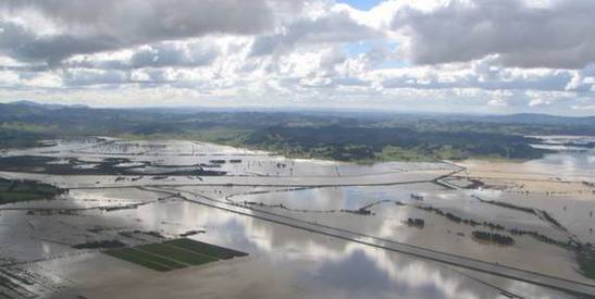
Flooding is the most common hazard in Northland, with several settlements and important farming areas located in flood plains. The Northland River Management Policy (NRC 2006) provides an integrated approach to flood hazard management, including:
· Hazard identification and risk assessment:
· Risk avoidance by controlling development on flood-prone land, or authorising only development that can withstand flooding;
· Risk reduction by undertaking flood mitigation works;
· Site and event-specific emergency management plans to assist communities to cope with greater-than-design events;
· Disaster recovery plans for communities that are at risk.
Under the River Management Policy, the Regional Council is actively involved in a number of river management schemes to reduce the incidence, frequency and duration of flooding, particularly where human life and property is at risk.
The Awanui River Flood Management Scheme became the Regional Council's responsibility in 2005. After extensive consultation the Awanui River Flood Management Plan was formally adopted by the Council in April 2005. For more information on the Awanui River Flood Management Scheme and Plan, check out case study 1.
During 2006, the Council also assumed responsibility for management of the Kaihu River. After extensive consultation, the Interim Kaihu River Management Plan was formally adopted on 18 October 2006. The Interim Kaihu River Management Plan is available on the Regional Council website.
Draft River Management Plans have also been prepared for Waima, Waimamaku and Mangakahia Rivers, and Otaika and Mangatara Streams (Otaua). These Draft Plans have not yet gone through a public consultation process or been finally adopted by the Council. However, these waterways are currently being managed according to these Draft Plans.
The NRC operates a hydrometric network consisting of 60 sites throughout Northland, which collect continuous river level or rainfall data. Of these 60 sites, 54 are part of a telemetry system, which provide a real-time picture of the state of the region's water resources. During periods of extreme rainfall, the telemetered sites play an important role, in monitoring river levels and providing flood warnings, where possible. The network also includes a telemetered tidal station at Marsden Point, which is part of the Pacific Rim tsunami-monitoring network.
For more information on the Regional Council hydrometric network check out the surface water quantity chapter.
Coastal hazards
The Regional Council has carried out several coastal hazard assessments over the last 20 years to determine coastal hazard zones. Coastal hazard zones are included in District Plans, which enable the District Councils to avoid or mitigate inappropriate development in areas subject to coastal hazards. For more information, check out the coastal hazards chapter of this report.
Fire
The whole of Northland is provided with firefighting cover by one paid Fire Brigade, 27 Volunteer Fire Brigades, two Rural Fire Parties and 20 Rural Fire Forces along with additional firefighting capability maintained by the Territorial Authorities, the Department of Conservation and major forestry companies. These organisations work alongside each other to ensure that there are sufficient trained personnel and adequate equipment available to suppress any wildfires that may start. These authorities also work together to monitor the weather and the fire indices and regulate fire seasons by putting fire restrictions in place when deemed necessary.
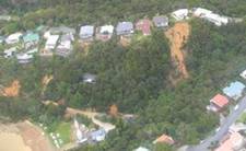 Land instability
In most cases, the best way to avoid land instability is to identify the areas at risk and then avoid siting buildings and infrastructure in these areas.
Mine subsidence
There has been extensive mine subsidence assessment carried out for the old Kamo coal mine and the Hikurangi coal field. The Whangarei District Plan recognises mining subsidence as a natural hazard in mined areas, has requirements that must be met before a new building can be approved for construction and zones the mine subsidence hazard areas (Beetham et al. 2004).
Readiness
The Civil Defence Emergency Management Act 2002 sets out how civil defence should be managed around New Zealand. The Northland Civil Defence Emergency Management Group is legally required under the Act to develop and implement plans to reduce the risks associated with hazards.
Civil Defence Emergency Management Group
In Northland, the Civil Defence Emergency Management (CDEM) Group is a partnership between the local authorities of the region together with the emergency services and other agencies, formed to ensure the effective delivery of civil defence. Political representatives sit on the CDEM Group which is effectively a governance body. The CDEM Group works together to:
· Reduce the potential effects of hazards.
· Promote community and Council readiness (preparedness) and ability to respond to emergencies.
· Help the community to recover after an event.
Training and exercises
The CDEM Group is responsible for ensuring the provision and coordination of training. In recent years the focus for training has been on Coordinated Incident Management Systems (CIMS), which is recognised nationally as the standard operating procedure when agencies work together to respond to a major incident. Every year more than 100 people from a variety of emergency response organisations across the region participate in the CIMS training.
The group also coordinates and provides other specialist training courses for controllers, recovery managers and other specialists and participates in regular local, regional and national exercises. For example in early 2008 the Northland CDEM Group was to be involved in responding to a national emergency scenario centred on a volcanic hazard in the Auckland region.
Northland Civil Defence Emergency Plan
The Northland CDEM Group has prepared the Northland Civil Defence Emergency Management Group Plan, which provides the context and strategic direction for civil defence emergency management in the region. This plan includes a process for:
· The identification of hazards.
· Risk reduction or avoidance.
· Readiness for major hazard events.
· An ability to respond.
· After the event, an ability for affected communities to recover.
Response
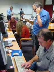 In the event of a civil defence emergency, the Northland Regional Council has the responsibility for providing the Northland CDEM Group Emergency Operations Centre (GEOC) in Whangarei. The GEOC coordinates the regional civil defence emergency response and may be activated to monitor a potential emergency or to respond to or recover from an emergency situation that is occurring or has occurred. The photograph (right) shows staff in the GEOC during the March 2007 flooding event.
A major role of the GEOC is the collation and dissemination of important information such as areas affected and damage to infrastructure, including road closures, power and telecommunications outages, disruption to water supplies and planning for the recovery phase.
Each of the District Councils also may activate and operate an Emergency Operations Centre to provide direct coordination and control of civil defence operations within their District.
Recovery
 The CDEM Group also helps the community to recover from natural hazard events. The process of recovery is to re-establish the quality of life of the community following an emergency. Recovery starts as soon as possible in the local community and addresses the social, economic, natural and built environment.
There was severe damage to agricultural and horticultural land, homes and infrastructure following the March and July 2007 floods. The Council, together with other organisations, assisted recovery by meeting with community groups, seeking financial support from central government and coordinating recovery activities such as the clean-up work of the Enhanced Task Force Green crews.