15.3 What is the state of biodiversity?
The overall state of biodiversity in Northland is difficult to assess by any simple measure. However there are key species which are good indicators of environmental change and are straight-forward to monitor. These include species such as freshwater fish, kiwi and some plants which are vulnerable to pressure and are relatively sedentary or occupy narrow habit ranges.
 In addition we also have sufficient information about most non-cryptic species to be able to assign them a population status and threat ranking based on the International Union of the Conservation of Nature (IUCN) threat categories.
Indigenous vegetation
Overall the biodiversity of indigenous vegetation is declining with a decrease in the land area covered in indigenous vegetation between 1997 and 2002, indigenous plants becoming extinct and many species becoming nationally or regionally threatened.
However a significant proportion of this remaining indigenous vegetation is legally protected. There is also evidence that restoration and pest control work can ensure the survival of a rare species as is the current case for Holloway's crystalwort.
Extent of indigenous vegetation and legal protection
In 2002 approximately 416,900 hectares (33%) of Northland's land area was covered in indigenous vegetation, as shown in table 1 (below). There was a slight decrease in the land area covered in indigenous vegetation from 1997 to 2002, which was approximately 419,100 ha in 1997. This is mostly through a decrease in the following vegetative land covers: broadleaved indigenous hardwoods, indigenous forest and manuka/kanuka. However, more concerning is the loss in fernland, although only 19 hectares were lost; this was 25% of the fernland habitat that existed in 1997.
However, since 2002 it is possible that this trend has stabilised or changed to a slightly increasing trend, due to the significant amounts of protection and enhancement of indigenous biodiversity that is being carried out in Northland.
Table 1: Estimated area of indigenous land cover in Northland in 1997 (LCDB1) and 2002 (LCDB2), the percentage chance over these five years and the area of each land cover class in legal protection
| Indigenous land cover class | Area (Hectares) |
Area legally protected in 2006 |
|||
| 1997 | 2002 | % differ |
Hectares | % of 2002 |
|
| Broadleaved indigenous hardwoods | 18176 | 17710 | -2.56 | 2360 | 13.3 |
| Depleted tussock grassland | 7 | 7 | 0.00 | 0 | 0.0 |
| Fernland | 76 | 57 | -25.43 | 5 | 9.5 |
| Flaxland | 168 | 168 | 0.00 | 70 | 41.5 |
| Grey scrub | 341 | 339 | -0.40 | 134 | 39.5 |
| Herbaceous freshwater vegetation | 7053 | 6993 | -0.85 | 2045 | 29.2 |
| Herbaceous saline vegetation | 3368 | 3368 | 0.00 | 358 | 10.6 |
| Indigenous forest | 256585 | 255724 | -0.34 | 106822 | 41.8 |
| Mangrove | 14614 | 14614 | 0.00 | 1259* | 8.6 |
| Manuka and/or kanuka | 118706 | 117930 | -0.65 | 34815 | 29.5 |
| Total native vegetation cover | 419094 | 416910 | -0.52 | 147868 | 35.5 |
| Estuarine open water | 24727 | 24727 | 0.00 | 188 | 0.8 |
| Coastal sand and gravel | 16217 | 16163 | -0.34 | 8216 | 50.8 |
| Lake and pond | 4140 | 4159 | 0.45 | 706 | 17.0 |
| Landslide | 16 | 16 | 2.16 | 6 | 38.5 |
| River | 1968 | 1968 | 0.00 | 44 | 2.2 |
| River/lakeshore gravel and rock | 34 | 34 | 0.00 | 13 | 37.7 |
| Total other native land cover | 47103 | 47068 | -0.08 | 9173 | 19.5 |
| Total native land cover | 466197 | 463978 | -0.48 | 157041 | 33.8 |
*As discussed below this does not include the protection given to mangroves in the RCP.
Of the 416,900 ha of indigenous vegetation land cover in Northland in 2002, approximately 36% of it was legally protected in 2006, as shown in table 1 (above) and figure 1 (below). Legally protected land includes Department of Conservation reserves, QEII covenants, WDC covenants, wildlife refuge or district council reserves, where the land has been set aside as a reserve for the protection of flora, fauna or wildlife reasons. This doe not include the protection mangroves are given within section 9 of the Regional Coastal Plan for Northland (NRC 2004) and therefore mangroves have been presented seperately in figure 1 (below).
The indigenous land cover protected in Northland in 2006 was predominately indigenous forest and manuka/kanuka. Of the 57 hectares of fernland remaining in 2002, only five hectares was legally protected in 2006.
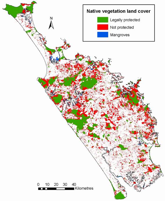
Figure 1: Native vegetation based on land cover classes from the LCDB2 (MfF 2002) that are legally protected, including QEII covenants, WDC covenants, wildlife refuge, DOC reserves and District Council reserves for the purpose of wildlife protection. Note: Mangroves have some protection through the Regional Coastal Plan for Northland (NRC 2004).
Plant extinctions
 There are around 179 native vascular plant species listed as threatened in Northland Region (Forester and Townsend 2004), as shown in table 2 (below). This does not include fungi, bryophytes or other non-vascular species. Of the species listed one plant, Adams mistletoe (Trilepidea adamsii), which was known from Waipoua Forest, Hoteo River and Wellsford, is extinct, whilst at least a further eight, including kakabeak (Clianthus puniceus), helmet orchid (Anzybas carsei) and quillwort (Isoetes kirkii) are presumed locally extinct in Northland.
Right: Painting of Adams mistletoe by Fanny Osbourne
There are a large number of other plant species which, although not nationally threatened, are listed as rare or are believed to be locally extinct in Northland. These include plants which are at the northern limits of their distribution, plants which are naturally rare and plants such as wire rush (Empodisma minus) which have become rare in Northland as a result of land clearing or other anthropogenic changes. The regionally threatened and uncommon plant list currently being developed for Northland will assist with management of these species.
Table 2: Number of threatened plant taxa in Northland by threat category
| Threat category | Number of plant taxa |
| Extinct | 1 |
| Acutely Threatened | |
| Nationally critical | 24 |
| Nationally endangered | 17 |
| Nationally vulnerable | 3 |
| Chronically threatened | |
| Serious decline | 13 |
| Gradual decline | 25 |
| At risk | |
| Range restricted | 52 |
| Sparse | 31 |
| Data deficient | 13 |
| Total | 179 |
 Restoring an extremely rare plant population
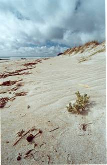
Holloway's crystalwort (Atriplex hollowayi) is a small NZ annual plant which grows near the high tide level over summer, as shown in the photograph (right). It use to grow on the east coast as far south as Wellington but over 100 years ago it began a Northwards retreat and by the 1970's was restricted to the Far North. Possible reasons for its decline include browsing and trampling of its delicate stems by rabbits, stock, horses and pigs, vehicles on beaches, competition by exotic beach plants, sandmining and alteration of beach profiles by land development. By the turn of the century annual crystalwort numbers were down to just a few plants and it was almost certainly heading for extinction.
This sparked a massive rescue effort by Department of Conservation staff and the local Far North community. A Recovery Plan was written and fencing, weeding, stock control and a big replanting programme were undertaken every summer. The aim was for plants to produce as much seed as possible on the beaches so it would be available in the sand seed bank for years to come.
The rescue was spectacularly successful with many wild plants coming up in subsequent years and by 2003 plants were being seen on beaches further south of where it had grown for many years. In the last two years there have been thousands of wild plants on the beaches in the Far North and the replanting programme has been scaled down. The crystalwort project is one of few recovery programmes for plants that has been successful but this plant will require ongoing management if it is to survive into the future.
Threatened species
Plant and animal species in New Zealand can be given a population status and threat ranking based on the International Union of the Conservation of Nature (IUCN) threat categories.
Of the 169 plants classified as nationally critical (under the most threat of extinction) in 2002, 28 (17%) were present in Northland and three had become extinct from Northland, as shown in table 3 (below). While 36 of the 120 (30%) terrestrial animals classified as nationally critical and 5 of the 21 (24%) freshwater and marine animals classified as nationally critical were present in Northland in 2002.
Over the last few years since the last review of threat rankings the status of most Northland species have not moved up to higher threat rankings indicating that the state of biodiversity, at least in the short term, has remained fairly stable. However in the case of many of our most chronically threatened species neither has there been an improvement.
Table 3: Number of threatened taxa of Northland and New Zealand – 1994 and 2002 categories. (Hitchmough 2002)
Number of taxa (species and sub species combined) |
Northland | Northland | Nationally | Northland | |
| Locally extinct | Present | Present | % Present | ||
Plants |
Nationally critical | 3 | 28 | 169 | 16.6 |
| Nationally endangered | 0 | 22 | 77 | 28.6 | |
| Nationally vulnerable | 0 | 3 | 23 | 13.0 | |
| Serious decline | 1 | 11 | 30 | 36.7 | |
| Gradual decline | 2 | 20 | 84 | 23.8 | |
| Sparse | 0 | 32 | 149 | 21.5 | |
| Range restricted | 0 | 69 | 523 | 13.2 | |
Terrestrial Animals |
Nationally critical | 4 | 36 | 120 | 30.0 |
| Nationally endangered | 5 | 31 | 117 | 26.5 | |
| Nationally vulnerable | 1 | 3 | 18 | 16.7 | |
| Serious decline | 0 | 7 | 25 | 28.0 | |
| Gradual decline | 1 | 19 | 69 | 27.5 | |
| Sparse | 0 | 31 | 94 | 33.0 | |
| Range restricted | 1 | 154 | 440 | 35.0 | |
Freshwater and Marine Animals |
Nationally critical | 0 | 5 | 21 | 23.8 |
| Nationally endangered | 0 | 2 | 6 | 33.3 | |
| Nationally vulnerable | 0 | 1 | 2 | 50.0 | |
| Serious decline | 0 | 2 | 6 | 33.3 | |
| Gradual decline | 0 | 4 | 17 | 23.5 | |
| Sparse | 0 | 2 | 29 | 6.9 | |
| Range restricted | 0 | 84 | 288 | 29.2 | |
Threatened environments
In April 2007 the Ministry for the Environment released the Statement of National Priorities for protecting rare and threatened native biodiversity on private land, which identifies the types of ecosystems and habitats most in need of protection. The four national priorities for biodiversity protection are:
1. To protect indigenous vegetation associated with land environments (defined by Land Environments of New Zealand at Level IV), that have 20% or less remaining in indigenous cover.
2. To protect indigenous vegetation associated with sand dunes and wetland; ecosystem types that have become uncommon due to human activity.
3. To protect vegetation associated with "originally rare" terrestrial ecosystem types not already covered by priorities 1 and 2.
4. To protect habitats of acutely and chronically threatened indigenous species.
National priority one
Nationally, close to 468,000 hectares of unprotected native vegetation is in land environments reduced to less than 20 percent of their original extent, of which 5% is in Northland. Northland has 23,202 hectares (about 2% of region) of indigenous vegetation remaining that is not legally protected that falls into priority one land environments.
Figure 2 (below) shows the location of the Priority 1 land in Northland, the areas of remaining indigenous vegetation within the Priority 1 land (Walker et al. 2006) and whether or not this is formally protected (in May 2005). Formal protection in this map includes public conservation (DOC) land and land in QEII covenants.
Of the 23,202 hectares of priority one land remaining in Indigenous vegetation in Northland that is not legally protected (up to 2004), over half (12,204 ha) is in the Far North District and 6,072 and 4,926 ha is in Kaipara and Whangarei District respectively.
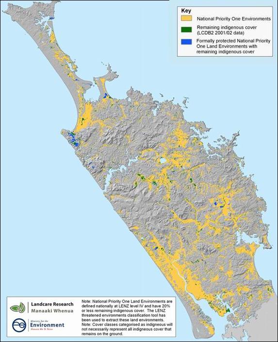
Figure 2: National Priority 1 land environments in Northland and the areas of which are remaining indigenous vegetation (both formally protected in blue and not protected in green).
Key indicator species
The overall state of biodiversity is difficult to assess by any simple measure. However there are key species which are vulnerable to pressure and are relatively sedentary or occupy narrow habit ranges, such as freshwater fish, kiwi and some plants, making them good indicators of environmental change.
North Island kiwi
Northland is a mainland stronghold for North Island or brown kiwi (Apteryx mantelli). There are 25 clusters of kiwi population remaining in Northland, all of which extend across both private and public land.
Kiwi populations in Northland have declined greatly due to loss of habitat, predation by a range of predators and impact of motor vehicles. Kiwi call monitoring showed that call rates declined in all areas during the 1990's with catastrophic declines in some areas, these declines were primarily attributed to the impact of predators. As kiwi are very long lived and slow breeding the populations are very vulnerable to any increases in threats.
This vulnerability is further increased as juveniles are more vulnerable to predation, so many of the existing populations are comprised mostly of older birds. Without active, on-going protection efforts kiwi numbers in Northland will continue to decline with mainland populations likely to become extinct within 50 years. Active management in areas where kiwi are present will increase the number of juveniles surviving through to an age where they can breed.
Kiwi populations are currently being managed at about 30 sites across Northland. This covers at least 53,000 ha and includes most of the identified population clusters. This predominately involves pest control and public education. Due to these efforts, the kiwi population in Northland in these managed areas is increasing. Since 1999 call rates from kiwi monitoring have stabilised, with an increase in call rates at one of the four areas monitored.
New Zealand dotterel
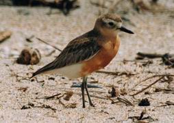 The NZ dotterel (Charadrius obscurus) is one of New Zealand's endangered endemic shorebirds. The NZ dotterel consists of two subspecies; the northern subspecies is found on the northern coasts of the north island and the southern subspecies on Stewart Island. The northern subspecies was once widespread and common but now numbers are only about 1700 birds (Dowding & Davis 2007). The NZ dotterel's international status (IUCN) is ‘Endangered' and under the New Zealand threat classification is ‘Nationally Vulnerable' (Hitchmough 2002). The population is currently considered to be stable but this is dependent on continued conservation management.
The decline of the NZ dotterel is due to a combination of factors, mainly predation by introduced mammalian predators, human-related disturbance during their breeding season, and habitat loss and degradation through coastal development.
The northern NZ dotterel (C. o. aquilonius) inhabits the coast of the North Island, north of a line between Taranaki (Kawhia) and northern Hawke's Bay. The birds are most numerous on the east coast of Northland, Auckland, Coromandel and Bay of Plenty, and following a population increase of around 4% between 1989 and 1996 (Dowding 1997) the breeding range has recently expanded into the Gisborne area.
In Northland the dotterel populations have remained relatively stable since 1996 until the latest national census in 2004. The strong-holds in the Northland area are on the east coast at Mangawhai, Waipu, Ruakaka and Mimiwhangata. There are about 600 birds on the east coast. The birds on the west coast number around 150 individuals and often occur as one or two pairs scattered along long stretches of coast, based around the mouths of small streams.
Two of the Northland sites are extremely important for NZ dotterel conservation: Mangawhai Sandspit hosts the second highest number of breeding pairs (about 30 pairs) and a large post-breeding winter flock number of about 150 birds. Waipu Estuary has about 15 breeding pairs and 30-40 post-breeding birds. Both these sites have Wildlife Refuge status and are managed by the Department of Conservation. Summer wardens are employed to carry out monitoring, nest protection, advocacy and predator control. People in coastal communities also ‘keep an eye' on the nesting dotterels, often fencing off nests and trapping for predators.
However, as these coastal strips become more highly developed there will be increasing pressure on the dotterels from human-related disturbance, particularly from recreational activities and habitat degradation. Protection of the birds and their habitat, predator control and management of the impact of recreational activities at these sites will continue to be required to maintain the NZ dotterel populations. This is particularly important as research has identified that there are two sub-populations in the North Island: Northland/Auckland, and Coromandel/Bay of Plenty, with little or no interchange. Also the birds productivity (the number of chicks fledged per pair) at managed sites is at least twice as great as at un-managed sites (Dowding 2001).
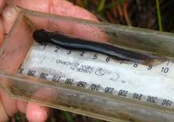
Northland mudfish
The Northland mudfish (Neochanna heleios) is only found in Northland and its distribution is restricted to wetlands in the Kerikeri, Ngawha and Lake Omapere areas, as shown in figure 3 (below). It is classified as nationally endangered. A unique characteristic of mudfish biology is the fish's ability to aestivate in mud during periods of low water levels in wetlands. This means that mudfish activity is greatly affected by water levels in the wetlands.
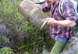
Photograph showing typical Northland mudfish habitat and a gee minnow trap being checked as part of annual monitoring (right).
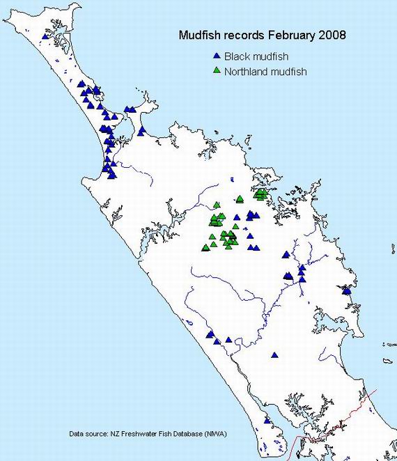
Figure 3: Mudfish records for Northland
The total number of mudfish caught at two of the monitoring sites is shown in figure 4 (below). The Ngawha sites shows very little variation in the number of fish caught, while at the Kerikeri site there has been significantly less mudfish trapped in the last two years.
As discussed above this is likely to be attributed to environmental conditions and it is too early to assess whether this is a decline in the population. Department of Conservation will continue with annual monitoring of Northland mudfish.
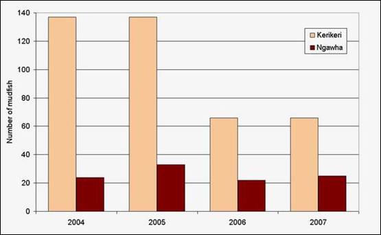
Figure 4: Total number of Northland mudfish caught along the transects at both Kerikeri and Ngawha C monitoring locations in each annual survey.
Freshwater biodiversity
The status of aquatic vegetation and fish in Northland lakes, including both native and exotic species, is covered in the Lakes section of this SOE report. Note that the fish data is restricted to what has been recorded in the NIWA managed New Zealand Freshwater Fish Database.
There is currently very little biological monitoring carried out on Northlands rivers. Stream macroinvertebrates are monitored annually at the Regional River Water Quality Monitoring Network sites and used as an indicator of water quality. For more information check out the surface water quality chapter of this report.
There is currently no routine state of the environment monitoring of freshwater aquatic vegetation, freshwater fish species or wetland habitat quality.
Fish monitoring in Northland is currently restricted to:
· rare species such as the Northland mudfish, dwarf inanga, dune lake galaxiids and short jaw kokopu, mostly by the Department of Conservation inline with recovery plans.
· presence/absence monitoring by consent applicants for environmental impact assessment reports to gather background information for resource consent applications.
Most of this information is recorded in the New Zealand Freshwater Fish Database (NZFFD), managed by NIWA.
Native fish
As of December 2007 there were 20 native freshwater fish species recorded in Northland (see table 5 in Appendix A). The most frequently recorded are short fin and long fin eels.
 Many of these species are important to Northlands', New Zealand's and international freshwater biodiversity. Many of our native freshwater fish species are endemic to NZ (not found anywhere in the world). The Northland mudfish (as discussed above) is only found in Northland, and is classified as ‘nationally endangered' on the threatened species list (Hitchmough 2002).
Dwarf inanga and dune lake galaxias are only found in the Kai Iwi and Pouto dune lakes in Northland, as shown in figure 5 (below). Other than this they are only found in a couple of dune lakes on the South Head of the Kaipara Harbour in the Auckland Region. They are classified as ‘nationally vulnerable'. Note that dune lake galaxias are different to dwarf inanga as they have been geographically separated for so long.
In Northland, giant kokopu have only been found in one dune lake, as shown in figure 5 (below) and have a national classification of ‘gradual decline'. Short jaw kokopu are also relatively rare in Northland, being recorded at about 10 different locations. They have a national classification of ‘sparse'.
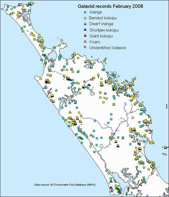
Figure 5: Records of Galaxiid species in Northland.
Introduced fish
There are 12 introduced fish species recorded in Northland (see table 5 in Appendix A). The most widespread is the mosquito fish (Gambusia affinis), as shown in figure 6 (below), which is an extremely aggressive pest fish that is known to attack native fish. Gambusia are prolific breeders that give birth to live young, allowing population size to increase rapidly.
The coarse fish species such as koi carp, goldfish, tench and rudd, are also very destructive to freshwater ecosystems, by predating on or competing with native fish for food and habitat and depleting native vegetation in lakes. These pest fish are also prolific breeders. The known extent of these pest fish species in Northland is currently limited to records in the NZFFD and is likely to be under-estimated.
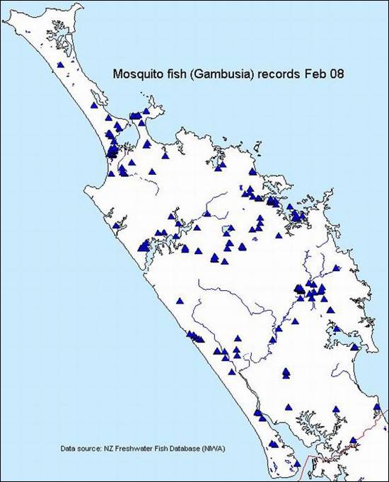
Figure 6: Mosquito fish (Gambusia) records for Northland (left).
The most widespread freshwater game fish species in Northland is the brown trout, which has been released in many of Northlands waterways for the purpose of recreational fishing. Brown trout eat mostly aquatic invertebrates, so can compete with native fish species such as galaxiids for food.
Aquatic plants
The tiny native rush-like plant Hydatella inconspicua lives in the shallows on the edges of Northland dune lakes which are in good condition. It is also found in the South Island. It is known from two lakes in the Far North, all three Kai Iwi lakes and two lakes at Pouto. However due to competition from aquatic weeds it has disappeared recently from a further two lakes at Pouto highlighting the need for vigilance in preventing the spread of weeds into new lakes.