7.4 What is being done?
Policy documents
The Regional Policy Statement for Northland (NRC 2002) provides an overview of resource management issues in Northland, including those with regard to coastal natural hazards. It contains objectives, policies and methods to achieve integrated management of Northland's environment.
The objective of the Regional Policy Statement, related to natural hazards, seeks to avoid or mitigate the adverse effects of natural hazards by minimising and where practicable, avoiding the risk to life and damage to property, infrastructural services and other aspects of the environment, from natural hazard events.
The Regional Coastal Plan for Northland also contains objectives and policies for the management of the coastal resource relating to natural hazards. These aim to minimise or avoid the effects of natural hazards on people, property, and other aspects of the environment, consistent with the Regional Policy Statement for Northland.
New Zealand Coastal Policy Statement
The New Zealand Coastal Policy Statement (NZCPS) (DOC 1994) sets the national priorities for activities within the coastal environment that may affect coastal hazards.
The key policies of the NZCPS, relating to coastal hazard management state that Councils should:
· Identify where natural hazards exist.
· Recognise sea-level rise.
· Recognise and enhance the ability of natural features to protect development.
· Recognise that natural features may migrate inland.
· Locate and design development so that hazard protection works are avoided.
· Only permit coastal protection works where it is the best practical option.
Hazard assessments
Coastal hazard assessments are undertaken to determine coastal hazard zones (CHZ). CHZ delineate areas of coast that may be subject to natural coastal hazards. This zoning enables authorities to better plan and manage coastal development in areas susceptible to coastal hazards by providing building setbacks and/or restrictions on the type of development.
Coastal hazard assessments have been undertaken to delineate ‘coastal hazard zones' for over 24 Northland coastal settlements. The Northland Regional Council is also currently assessing tsunami hazard for the region, which may lead to the identification of tsunami hazard zones. The Northland Regional Council has commissioned several coastal hazard assessment reports over the last 20 years, shown in table 6 (below).
Table 6: Coastal hazard reports commissioned by the Regional Council
| Coastal Hazard Report | Date, Author |
| Coastal hazard identification Whangarei county. | 1988, NRC. |
| Urban capability classification and coastal hazard identification, Omapere-Opononi Area. | 1991, NRC. |
| Coastal hazard identification in former Mangonui county area. | 1991, NRC. |
| Review of coastal hazard zones for 11 selected beaches in Whangarei District, Northland Region. | 1998, CMCL. |
| Identification of coastal hazard zones at nine selected Northland beaches. | 2002, Geomarine International Ltd. |
| Overview of weather and coastal hazards in the Northland region – Part 2: coastal hazards | 2003, NIWA |
| Coastal inundation hazard assessment for selected Far North settlements. | 2005, NRC. |
| Tsunami source study. | 2006, NIWA. |
| Tsunami hazard baseline assessment for the Northland Region. | 2006, NIWA/NRC. |
District plans and coastal hazard zones
Coastal hazard zones, derived from the coastal hazard assessments, are included in District Plans. These lines are used to avoid or mitigate inappropriate development in areas subject to coastal hazards.
District plans also have minimum setback requirements for development adjacent to the coastal marine area, which helps avoid development in areas subject to natural hazards. Some district plans also have minimum coastal floor levels, which are designed to mitigate coastal flooding of dwellings.
Beach profile monitoring
A beach-profile monitoring programme is undertaken to assess changes in the shape and position of the shoreline at selected coastal areas.
The programme involves surveying the position of the toe of the foredune with a differential global positioning system and surveying one or more cross-sectional profiles of the foreshore and foredune complex at each beach. For example, the results from Ruakaka Beach are shown in figure 7 (below).
The programme was designed to provide coverage of a number of key ‘monitor' beaches in the region. This monitoring is carried out every six months, during summer and winter, at nine beaches throughout Northland. A further 15 beaches are surveyed once every two years or after events that cause substantial changes to the position of the shoreline such as storms and landslides.
Data gathered from this programme is necessary to better understand the dynamics of Northland's coastline. This data assists in assessing the suitability of developments in coastal areas and is also used in the delineation of coastal hazard zones.
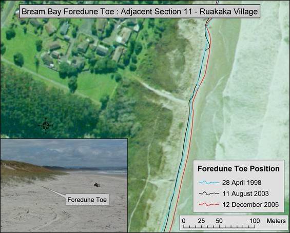
Figure 7: Foredune toe profile survey results near Ruakaka, Bream Bay.
Other responses
Submissions on resource consent applications
The Northland Regional Council reviews applications made to District Councils for activities, such as subdivision, land use and development and building, in areas subject to coastal hazards. The Northland Regional Council makes comments or submissions on these applications and suggests measures for mitigating or avoiding the enhancement of natural hazards. These measures may include undertaking detailed assessments of the natural hazards, building setbacks, requirement for relocatable dwellings and raised floor levels or avoiding the hazard area entirely.
Natural system restoration
The Northland Regional Council has a full time Coast Care Coordinator and an active coast care programme aimed at facilitating community-based restoration of dune systems. This programme provides for the mitigation of natural hazards, as well as restoring natural character and biodiversity of dunes.
Refer to case study 1 of the Coastal Management chapter of this report for more information on coast care.