6.4 What is being done?
Policy documents
The Government has prepared a New Zealand Coastal Policy Statement (DOC 1994), which sets the national priorities for the management of the coastal environment, with a particular emphasis on the preservation of natural character.
The NRC has prepared a Regional Policy Statement (RPS) for Northland (NRC 2002). The RPS contains section 22 - coastal management, which recognises and provides for the preservation of the natural character of the coastal environment and protection from inappropriate subdivision use and development.
Preservation is best achieved through control of development activities and requires, among other things, coordination between Regional and District Councils. The controls on activities in the Coastal Marine Area need to be related to those applying on adjacent land areas and vice versa. Special attention needs to be focused on areas with high natural values and complementary programmes of acquisition and formal protection developed.
The NRC has prepared a Regional Coastal Plan which is a self contained document with objectives, policies and rules governing management of the coastal marine area, i.e. the land and waters below mean high water springs mark. It provides the basis for allocating space to and controlling the effects of activities in this area.
The management of land, water and other resources above Mean High Water Springs are dealt with in a similar manner in regional plans prepared by the Regional Council and District Plans prepared by the respective District Councils.
The split in planning area and associated jurisdictions of Regional and District Councils based around the Mean High Water Springs mark is a somewhat artificial one. Both levels of authorities recognise the need for integrated management of the wider coastal environment, as established by the planning framework set out in the RPS.
Beach profile monitoring
A beach-profile monitoring programme is undertaken to assess changes in the foreshore location and shape of the beach profile at selected coastal areas. Data gathered from this programme is necessary to better understand the dynamics of Northland's coastline. This data assists the Council in assessing the suitability and effect of developments on coastal systems. For more information, check out the Coastal Hazards section of this report.
Estuarine monitoring
The Northland Regional Council has commenced the implementation of the national Estuarine Monitoring Protocol programme (EMP) to assess estuarine habitat health and changes over time. The EMP assesses changes in both fine-scale estuarine health and broad-scale estuary habitat composition over time.
The fine-scale assessment involves routine sampling of a suite of characteristics relevant to estuarine condition, such as faunal and floral composition, nutrient and contaminant status and seabed sediment grain size characteristics. The broad-scale mapping of habitat characteristics is used to determine the proportion of different habitat coverage within the estuary.
 The main outcomes from estuarine monitoring are:
· A baseline assessment of estuarine sediment and ecological health and the habitat composition of estuaries.
· Continued assessment of changes in estuarine health, based on the above factors.
· The provision of quantitative data from which informed decisions can be made on the management of estuarine areas and activities impacting on these systems.
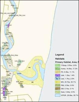
Example map of Ruakaka Estuary showing results of broad-scale habitat mapping.
NRC Environment Fund
The Northland Regional Council has an Environment Fund that is used to assist with funding projects that are designed to restore and enhance the natural environment, including coast care initiatives, the fencing of coastal margins, biodiversity enhancement and others.
This fund has recently been changed so that a portion ($25,000) is set aside specifically for coastcare initiatives and another $25,000 has been secured for CoastCare activities within the Bream Bay area. The Environment Fund amount proportioned within the Environment Fund is set to increase as the CoastCare programme in Northland gains momentum and more groups are established
Coastal plan changes
A plan change to the Regional Water and Soil Plan for Northland (NRC 2007) is being prepared to regulate land use in the coastal margins, preventing land disturbance activities from being adversely affected by marine processes or exacerbating the effects of these processes on other properties. There are also a number of natural, social and cultural values which may be affected by land disturbance activities undertaken in the coastal margin. These are being considered in the development of the plan change.
The following plan changes to the RCP for Northland all contribute towards the sustainable management of the natural character of Northland's coastal environment. These plan changes will occur over the next few years and will involve extensive consultation with the public and other stakeholder groups
Mooring and Marina Management
This change restricts the proliferation of moorings outside of identified mooring areas. It also initiates a new management regime within identified mooring areas through the development of mooring management plans. Mooring management plans will be developed for each of the roughly 40 identified moorings areas in Northland and will cover issues including maximum mooring numbers, mooring layouts and improve the integrated management of moorings through the identification of shore-based facility requirements like toilet and sewage pump-out facilities, and car parks.
Mangrove Management
This plan change has been developed to recognise that there are circumstances where the removal or pruning of mangroves is appropriate. Such activity would require resource consent with the application process taking into account relevant provisions of the New Zealand Coastal Policy Statement, Regional Policy Statement for Northland and Regional Coastal Plan for Northland.
Whangarei Harbour - Marine 1 Review
The purpose of this plan change is to identify and formally recognise areas of important conservation value within Whangarei Harbour, and to rezone these areas as Marine 1 (Protection) Management (MM1) Areas.
Aquaculture Management Areas (AMA)
This plan change is proposed to enable marine farming in Northland waters under an invited private plan change regime. Under this proposal, marine farm development outside of existing AMA would require a change to the Regional Coastal Plan. Resource consent approval would still be required to undertake any aquaculture activity within an approved AMA.
Stock exclusion from the coastal marine area
The Northland Regional Council is actively promoting the exclusion of stock from the coastal marine area and riparian management through the Regional Coastal Plan for Northland. Access to and use of the coastal marine area by stock is set to become a prohibited activity by June 2009.
This rule is supported by the employment of a catchment management officer and the delegation of NRC Environment Funds specifically for the fencing of riparian margins in the CMA.
Near-shore sand mining
The Northland Regional Council contributed to the Kaipara Sand Study, which was a multi-agency funded study, carried out from 2000 to 2004. The study provided a sustainable management context to assess the sustainability of sand extraction from this resource.
Applications for renewal of resource consents for near-shore sand mining near the entrance to Mangawhai Harbour were heard in 2004. The hearing committee, upon the advice of the Northland Regional Council, recommended the use of the precautionary principle, in this case being a cessation of sand mining. The decline recommended by the hearing committee was backed up by the Minister of Conservation who declined the application for the continuation of sand mining.
The only sand mining operation now left in Northland is within the Kaipara Harbour.
Vehicles on beaches
In response to increased concern from the public over the misuse of vehicles in the coastal environment, the Northland Regional Council is coordinating a multi-agency education campaign and working party with the Department of Conservation, NZ Police and District Councils. The education days are used to patrol the beach giving out safe driving information.