11.2 What are the pressures on groundwater resources?
Groundwater takes
Before 1980 groundwater water abstraction in Northland was relatively minor as water was mostly obtained from surface water supplies. Changing land use from traditional farming to horticulture and lifestyle blocks during the last two decades, together with a steady increase in subdivision and tourism, has resulted in an increase in groundwater abstraction and in turn an increasing pressure on many of Northland's aquifers.
Groundwater in Northland is used for agricultural, horticultural, public water supply, industry, and a variety of other purposes. Groundwater takes that meet the permitted activity take rules set out in the Regional Water and Soil Plan do not require resource consents. The majority of these water takes are for domestic and stock requirements.
Resource consents to take groundwater are monitored to provide information on the cumulative allocation in the aquifers. A summary of the bores registered with the Council, resource consents to take groundwater, and volumes allocated in the principal groundwater resources are shown in table 1 (below) and figure 1 (below).
Since the 2002 SOE report (NRC 2002b), the number of registered bores, groundwater consents and total volume of groundwater consented to be taken has increased. There is an additional 948 registered bores, 56 groundwater take consents, and 12,820 cubic metres of groundwater allocated via consents, when compared to the 2002 figures.
Table 1: Groundwater take consents, registered bores and water allocated by consent (m3/day) for Northland aquifers
| Aquifers | Number of consents | Number of bores | Allocation (m3/day) |
| Aupouri | 50 | 500 | 12,743 |
| Coopers/Cable | 7 | 47 | 617 |
| Taipa | 3 | 53 | 135 |
| Russell | 10 | 78 | 199 |
| Kaikohe | 7 | 41 | 1,476 |
| Matarau | 3 | 32 | 114 |
| Other small coastal aquifers | 17 | 278 | 268 |
| Glenbervie | 19 | 60 | 778 |
| Three Mile Bush | 12 | 93 | 1,050 |
| Maunu | 31 | 182 | 3,120 |
| Maungakaramea | 10 | 29 | 738 |
| Ruawai | 5 | 165 | 990 |
| Mangawhai | 15 | 64 | 710 |
| Tara | 5 | 11 | 612 |
| Outside "at risk" aquifers | 85 | 2114 | 26,052 |
| Total | 279 | 3747 | 49,602 |
| Increase since 2002 SOE report | 56 | 946 | 12,820 |
Many existing bores have not been registered with the NRC. Prior to 1999 bore logs were submitted to the Council on an informal basis. Recent surveys in coastal aquifers indicate only a small number of existing bores are actually registered with the Council.
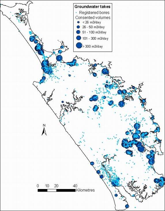
Figure 1: Registered bores and the volume allocated (m3/day) by groundwater take consents.
Seven percent of consents granted are for the taking of groundwater for industry as shown in figure 2 (below left). However, the volume actually allocated for industrial use equates to 37 percent of the total volume of groundwater allocated as shown in figure 3 (below right). Takes for industry are not always associated with water use as they may also relate to ground dewatering to enable earthworks. The majority of the industrial groundwater takes are outside the principal "at risk" aquifers.
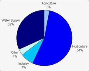
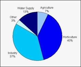
Figure 2: Percentage of groundwater take consents categorised by their use (left). Figure 3: volume allocated (m3/day) by these consents (right).
Fifty-four percent of consents to take groundwater are for horticultural irrigation, which equates to approximately 40 percent of the total volume allocated. The distribution of the takes can identify areas where additional groundwater monitoring may be required to ensure the future allocation is sustainable.
Bore construction and maintenance
Poorly constructed bores can result in groundwater contamination. This can occur in a variety of ways including:
· Surface contaminants flowing down the bore into the aquifer due to inadequate grouting and sealing of the bore.
· Mixing of aquifers of different water quality.
A consent is now required prior to the installation or alteration of all bores in the region. Site inspections for all consented bores are carried out to ensure that the bore head is constructed in such a way as to prevent groundwater contamination.
Land use
Changes in land use can not only result in an increase in the quantity of water taken from an aquifer but can also influence the amount of rainfall infiltrating into the aquifer (recharge) and groundwater quality.
Development of forestry can result in interception of the rainfall via the tree roots and therefore reduces the recharge of an underlying aquifer. This can lead to a decline in the groundwater level and the amount of water flowing through the aquifer.
Land use changes into more intensive farming practices, including dairying and horticulture, can result in increased abstraction from aquifers. Intensifying land use can also potentially lead to groundwater contamination, due to the substances applied to the ground surface overlaying an aquifer.
Housing developments can also reduce the amount of recharge into an aquifer, as the rainfall is intercepted via paved areas and roofing and the water is diverted as surface stormwater flows.
The east coast of Northland has a large number of small coastal aquifers. Housing development in these areas can result in saltwater intrusion into the aquifer, due to reduced recharge and increased use. Housing developments above aquifers can also increase the risk of groundwater contamination due to inappropriate or poorly maintained effluent disposal systems (septic tanks).
Groundwater quality pressures can also include discharges from farming activities, domestic wastewater, closed and existing landfills and industrial activities. Accidental spillages from underground storage tanks and road transported products may also result in contaminants entering groundwater.
Climate change
In August 2006, the National Institute of Water and Atmospheric Research Ltd (NIWA) carried out a comprehensive assessment on the impact of climate change and climate variability on Northland's water resources based on all available literature. The assessment considered natural climate variability in the Northland region and the potential effects of predicted climate changes over the next 50 to 80 years.
The main points of the assessment should be noted:
· All predictions suggest an increase in temperature, particularly during the winter;
· Overall annual rainfall may not change, however, rainfall trends for the next 30 to 80 years are for increased dry periods (drought and low flows) and increased high intensity rainfall events (floods); and
· The change in rainfall trends and temperature is likely to result in decreased recharge to groundwater resources, and increased potential for saltwater intrusion in coastal aquifers.
Additional work is required to assess the potential effects of increased drought frequencies and extreme rainfall events on surface water flows such as low flows and environmental responses.