Land management
Soil Conservation Project
Sediment can be a contaminant of rivers, estuaries, harbours and inshore waters in Northland. It affects land productivity, water quality, ecological health and flooding throughout the region.
In its first year (2009-2010) the focus of the project was on the 27 priority river catchments but this changed as a result of the widespread slipping caused by Cyclone Wilma on the eastern side of Northland, from Doubtless Bay to Bream Bay.
Landowners became more interested in erosion control planting over a much wider area. The increase in demand for poplar poles cannot yet be met from within the region but the council is working with growers at several locations to ensure both poplar and willow pole supplies will come from local nurseries within the next two years.
The information from priority river catchment surveys and from an aerial survey immediately after Cyclone Wilma enables areas to be targeted for soil conservation initiatives, including planting native trees, poplars and willows, preparing farm plans and encouraging land use changes of marginal pasture land.
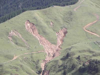 An example of a type of erosion caused by Cyclone Wilma and targeted by the Soil Conservation Project.
Why is sediment a problem?
· Sediment contaminates rivers, estuaries, harbours and inshore waters in Northland.
· It can smother aquatic life and change the nature of river beds and estuaries, encouraging the growth of mangroves.
· It reduces water quality and carries other contaminants, such as nutrients and in some areas trace metals.
· It reduces the value of water bodies for activities such as gathering kaimoana (seafood) and swimming.
· It reduces channel capacity and increases the risk of flooding.
· It builds up the ground level on flood plains, increasing the frequency with which buildings, roads and other infrastructure flood.
· It has a major effect on the visual quality of waterways.