Water allocation case study – Otaika catchment
The Sustainable Water Allocation project is working to update the water allocation regime in Northland to ensure that the needs of users and the environment are protected into the future.
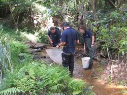 Electro-fishing and habitat surveys in Otaika catchment.
Key to this project is a stock-take of the water resources in the region to establish how much water is used. The Otaika catchment has been used as a pilot for this study. During 2010-2011:
· A new water level recorder was installed to collect seasonal stream flow information. Real time data will be used to manage low flow and flood events.
· A postal questionnaire was sent to all property owners in the catchment. Results from the survey provide valuable information on how much water is used, what it is used for and where it is sourced from. Results showed that 56 properties take surface water and 14 properties take groundwater as a permitted activity under the Regional Water and Soil Plan, which equates to 158m³/day and 20m³/day, respectively.
· A fish survey was undertaken to establish the types of fish that live in the catchment. Banded kokopu, torrentfish, longfin and shortfin eels, smelt and inanga were just some of the species found. The information gathered will be used to determine the river flows needed to sustain the life-supporting capacity of the water body.
· A rainfall runoff model was created to simulate historic low flows in the catchment. This model will be reassessed when actual flow records become available.
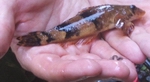 Torrentfish.
This information will enable us to provide feedback for policy development, consent processing and to the community on the state of Northland's water resource.
The next steps include reviewing groundwater and surface water interaction in the upper catchment and determining if the processes used in this case study can be applied to other catchments.