Specific groundwater investigations
Within this section…
Aquifer systems
The council undertakes a specific groundwater investigation where a potential issue has been identified, e.g. elevated nitrate or increased risk of saltwater intrusion in coastal areas. There are currently five aquifers in Northland that are subject to further investigation – Ruāwai, Taipā, Maungakaramea, Russell and Whatitiri.
|
Aquifer and use |
Issue |
Comments and Compliance with New Zealand drinking water standards (NZS). |
|
Taipā Domestic |
Salt water intrusion and nitrate |
Nitrate is still elevated but has not exceeded NZS in the past 12 months. Saline indicators are well below NZS. |
|
Ruāwai Domestic, stock, public drinking water |
Salt water intrusion and iron |
Chloride, sodium and iron concentrations remain elevated. Median chloride and sodium concentrations have exceeded the NZS at two sites and the median iron concentrations at all six sites exceed the NZS. The high iron is a result of natural processes. Sampling will be reduced. |
|
Russell Domestic |
Salt water intrusion and bacterial |
Saline indicators are well below NZS. The NZS for E.coli was not exceeded repeatedly – this is likely to be a result of the sewage reticulation system. |
|
Whatitiri Domestic, horticultural, irrigation, stock drinking |
Nitrate |
Nitrate is still elevated but has not exceeded NZS in the past 12 months. There appears to be a slight increasing trend and potential sources are being investigated. |
|
Maungakaramea Domestic, horticultural, irrigation, stock drinking |
Nitrate |
Nitrate is still elevated and has exceeded NZS on one occasion in the past 12 months. Seasonal trends are evident and potential sources are being investigated. |
The preliminary assessment report for Matarau / Ruatangata aqufiers was finalised in January 2011. The key findings of this report are:
- Rainfall is the source of recharge;
- The potential water available for allocation is around 7600 cubic metres per day; and
- Irrespective of the estimated water available for allocation, any future groundwater take application needs to be carefully considered based on the localised effects on springs and existing users.
Groundwater case study: a unique response to earthquakes
The groundwater level station located at Maunu responds to significant earthquakes that occur in the Pacific region. This appears to be unique in New Zealand and probably at a larger scale.
Examples of groundwater level fluctuations are shown in the graphs below for the Christchurch (4 September 2010) and Japan (11 March 2011) earthquakes. Water level fluctuations were also recorded following the Chile, Sumatra, Vanuatu and Kermadec Islands earthquakes.
In most cases the groundwater levels settled about 2-3cm lower than prior to the earthquakes. This is a unique response which raises a number of questions:
- Is this a response of the water in the bore hole or the whole basalt aquifer?
- What is the volume of water moved?
- Where does the water go?
The groundwater level data has been provided to specialists in the hope of gaining a better understanding of the changes caused by the earthquakes in the aquifer. It may also help explain the large-scale movements of Earth's lithosphere.
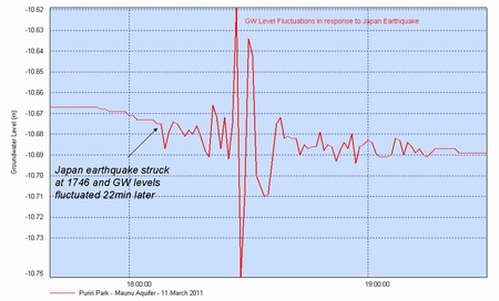
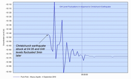
Puriri Park (Maunu, Whāngārei) groundwater level station is a unique seismograph. These graphs show the groundwater level fluctuations after Christchurch and Japan earthquakes.