Groundwater quantity
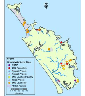
Monitoring groundwater levels provides information on the effects of climate, land use and abstraction on groundwater resources, and can tell us how much groundwater is available for use. A region-wide network of hydrometric stations is used to monitor groundwater. Levels are currently recorded continuously at eight sites, monthly at 42 sites and quarterly at 32 sites. The location of groundwater level monitoring sites is shown on the map below.
In 2009-2010, groundwater levels were found to be below average when compared to historic levels, falling significantly in February. The groundwater recharge was similar to previous years over winter 2009, but due to summer drought conditions combined with high water demand, groundwater levels dropped significantly in summer 2010. Most of the aquifers have now recovered but levels are still below those recorded last year.
The results of groundwater level monitoring for two sites during the last five years are shown in the graph below. These sites are located in two different aquifers and respond differently to rainfall recharge. Puriri Park bore is located in the fractured basalt aquifer which shows a strong seasonal rainfall recharge response. This site responded strongly to the drought conditions through the summer – the water level in the aquifer was almost a meter below the minimum water levels recorded in the last couple of years.
Hukatere piezo 2 (39 meters below ground level) is located in the Aupōuri sand/shell bed aquifer. This aquifer buffers seasonal variations and shows long-term rainfall variations with only minimum seasonal change.
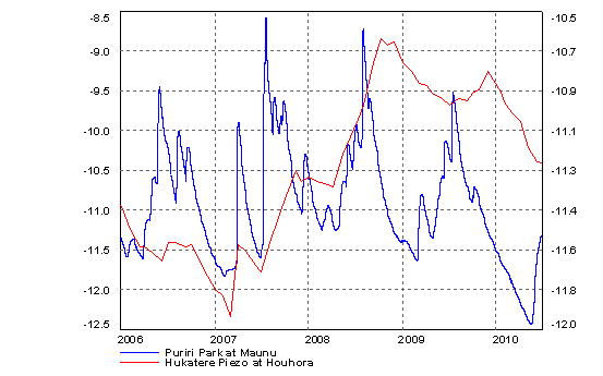 (Meters below ground level)
Aquifer Management Boundaries and recharge estimates were completed for 5 alluvial/basalt aquifers (Pakaraka, Okaihau, Waimate North, Morewa and Marsden/Ruakak), and 6 small coastal aquifers (Teal Bay, Tauranga Bay, Church Bay, Kowharewa Bay, Ohawini Bay and Taiharuru).