What we monitor and where
In 2009-2010, the Regional Council monitored five estuaries with new sites added in Whangaroa Harbour and Kaipara Harbour. In total, four sites were monitored in the Whāngārei Harbour, three sites in the Kerikeri Inlet and two sites in Ruakaka Estuary, Kaipara Harbour and Whangaroa Harbour.
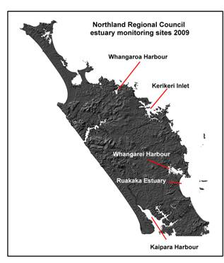
Map: Northland Regional Council estuary monitoring sites 2009
The Council's estuary monitoring programme uses methods described in the Estuary Monitoring Protocol, which was developed by Cawthron Institute for use by Regional Councils. This protocol ensures that the results collected by the Regional Council are scientifically credible and comparable to those collected throughout New Zealand.
A key element of the programme involves sampling the biological communities of representative intertidal habitats. In addition, the physical (sediment particle size) and chemical properties (nutrient and metal contaminants) of the sediment are monitored so that we can try to understand the factors that are influencing the biological communities at different sites.