Introduction
Northland has an abundance of rivers and streams, many of which are relatively short with small catchments. The Wairoa River is Northland's largest river, draining a catchment area of 3650 km2 (29% of Northland's land area). Most of the major rivers in the region flow into enclosed harbours, rather than discharging to the open coast, which has significant implications for coastal water quality.
The Northland Regional Council (NRC) carries out State of the Environment (SOE) monitoring on a number of rivers and streams throughout Northland to measure water quality, identify significant environmental issues and to monitor trends in water quality over time.
The Recreational Bathing Water Quality Programme is a joint project run by NRC, the District Health Board and the three District Councils; Whangarei, Far North and Kaipara. The programme monitors water quality at a number of the region's most popular coastal and freshwater swimming spots for 12 weeks over the summer months. Samples are taken once a week from each site and analysed for illness causing bacteria. The results are compared to water quality guidelines issued by the Ministry for the Environment (MfE) to establish whether or not sites are safe for recreational use.
The results from the programme are posted weekly on the NRC website - http://www.nrc.govt.nz/swimming - to allow the general pubic to make an informed decision about where to swim. Results are also passed to each of the District Councils and the District Health Board, who undertake investigation and take action in instances of non-compliance. During the 2007-08 summer season, NRC sampled water quality at 19 freshwater bathing sites. The results from this monitoring are presented in the Recreational Bathing Water Quality section of this report.
The River Water Quality Monitoring Network (RWQMN) involves the monitoring of water quality and macroinvertebrate biota in an increasing number of rivers around Northland. During 2007-08, 34 sites were included in the network, of which four are part of the National River Water Quality Network. Water quality at each site is monitored monthly for a range of parameters and stream macroinvertebrates are surveyed annually. The majority of sites in the network now have sufficient data for long-term trend analysis. The 2007-08 results and long-term trends in water quality are presented in the River Water Quality section below.
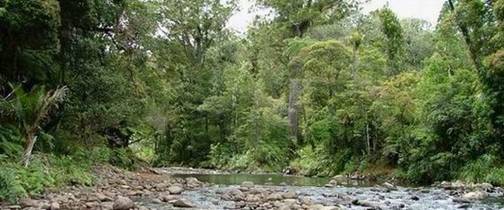
Photo: Waipoua River in Waipoua Forest