Case Study One: A very Stormy July 2007
Within this section…
Background
On 9 July 2007, the MetService issued a severe weather warning for Northland, Auckland and the Coromandal Peninsular, indicating the development of a low pressure system over the north Tasman Sea. This system was expected to deepen and move closer to Northland during Tuesday 10 July.
The low was forecast to bring periods of heavy rainfall and gale-force easterly winds. Up to 200mm of rain was expected to fall in Northland between Tuesday 10 and Wednesday 11 July. Rainfall intensities were expected to reach 15 to 25mm/hr. In addition, many areas would be exposed to damaging winds, with gusts of 120 km/h
Rainfall
Rain began to fall on the evening of the 9 July and became more intense during the early hours of Tuesday 10 July, continuing until 6pm that evening. Rainfall was recorded at the NRC's Kaeo station. The storm moved in a south-easterly direction and rain had cleared the far north by midnight on the 10 July. Further showers continued south of the Bay of Islands through Wednesday 11 July.
The heaviest and greatest rainfall amounts were recorded in the Awanui and Kaeo River catchments, coastal areas north of Kaeo, the headwaters of the Waipapa River in the Puketi Forest and in the high altitude areas of the Waima Ranges (South Hokianga, Kaihu and Mangakahia Rivers). At the Kaeo rain station, 241mm was recorded over 12 hours. Over this period, rain intensities varied from 13mm/hr to 36 mm/hr.
At the Puhipuhi rain station, total rainfall recorded over 24 hours was 217mm and the maximum rainfall intensity reached 39.5mm/hr. Other areas of Northland that received significant rainfall amounts included the Mangamuka Hills (166 mm over 24 hours, max intensity 31 mm/hr), Waima and Tutamoe Ranges (134-172mm, 34.5mm/hr), Whangarei (180mm, 20.5mm/hr), the east coast at Oakura and Glenbervie (122mm, 32.5mm/hr) and Maungaturoto (111mm).
Before the July event, 20 of the preceding 30 days were wet with total rainfall for the month around 200 to 250mm already. Consequently, the storm arrived on top of already wet ground conditions, increasing runoff into already elevated rivers and streams.
Water Levels
Widespread, severe flooding throughout much of Northland resulted from record high river levels. Kaeo township flooded and bore the brunt of the storm. The water through the town was over a metre high in some places.
Four sites with long-term records (20 to 30 Years) reached their highest ever recorded water level and several, the second highest recorded. The Mangakahia, at Titoki, was a metre higher than the levels recorded during Cyclone Bola. The Waiharakeke River behind Moerewa was a centimetre lower than the highest recorded 36 years ago in 1971. The stop banks along the Wairua River in the Hikurangi Swamp overtopped flooding vast areas of the Hikurangi Swamp.
Flooding occurred in Kaitaia after flood waters spilled from the Tarawhataroa Stream. Similarly, the Whangatane spillway over-topped its banks. Flooding also occurred south of Kaitaia township at Mangamuka, Rangiahua and Taheke. SH1 was closed in a number of places including Whakapara, Ruakaka, Waipu and the Brynderwyns.
Flood waters from the Northern Wairoa River closed SH14 at Kirikopuni, as a result of record river levels in the Mangakahia and Wairua Rivers. The Kaihu valley was flooded closing SH12 at Rotu. Large areas of low lying river flats were also flooded at Tangiteroria and Pukehuia. A flood warning was issued for Dargaville because of the high water levels in the Northern Wairoa River coinciding with high tide.
Many other highways and rural roads were closed for a time, either due to flooding, slips or downed trees. The gales were responsible for major power outages across the region.
Wind
Climate data from NRC's climate station at Dargaville indicated average wind speeds of around 70km/hr during the evening of 10 July, with sustained gusts of 110km/hr and a maximum gust of 125km/hr (34.7 m/s). Winds were largely from the easterly quarter later swinging to the south-east. The gale force winds generated a significant storm surge on the east coast, elevating high tide levels by approximately 0.4 metres.
The NRC commissioned NIWA to provide extensive analysis of rainfall, river flow and wind information from the storm event. For more information, go to:
http://www.nrc.govt.nz/Resource-Library-Summary/Research-and-reports/Natural-hazards/
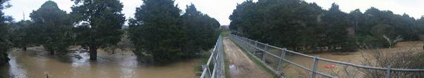
Photo: Waiharakeke in flood, July 2007