Introduction
The quantity and quality of groundwater resources in Northland is highly variable and is dependant on the geology of the aquifer system in which it is contained. In Northland, the main aquifer systems exist in the basalts, such as Kaikohe and Whangarei, and in the Aupouri sands. There are also many smaller sand and gravel coastal aquifers, and less productive greywacke aquifers, spread throughout the region. Rainfall is the main recharge source for Northland's aquifers.
Monitoring of groundwater resources in the Northland Region can be divided into three main areas:
· State of the Environment monitoring to meet performance targets for groundwater monitoring;
· Compliance monitoring, which is the monitoring of consented and ‘permitted' activities that affect groundwater, such as drilling and groundwater takes; and
· Specific groundwater investigations.
State of the Environment monitoring aims to identify environmental issues which may affect our groundwater resources, as well as trends in groundwater quantity and quality over time. This information is used by Northland Regional Council (NRC) and other organisations in environmental decision making. Several different networks are in place to collect this information, including a Regional Groundwater Level Monitoring Network and two groundwater quality monitoring programmes.
Groundwater level monitoring was undertaken in 82 bores in Northland during 2007-2008. Low groundwater levels were recorded at sites from Kaikohe to Mangawhai in 2006-07, as a result of low winter rainfall in 2004-05, however these levels have now recovered and above average levels were recorded for many sites during 2007-08.
Groundwater quality monitoring was carried out at seven sites during 2007-08 as part of the National Groundwater Monitoring Programme (NGWMP), 29 sites as part of the Regional Groundwater Quality State of Environment (SoE), and 18 sites as part of specific groundwater investigations.
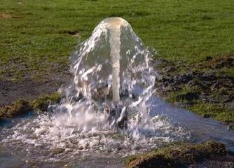
Photo: Overflowing artesian bore
Compliance monitoring includes the monitoring of bore construction and groundwater take. During 2007-08, 25% of the bores inspected did not fully comply with bore construction requirements. Action taken to remedy this non-compliance included letters to pump installers and a ‘Drillers Seminar', to encourage improved compliance in the future. No formal enforcement action was taken during 2007-08 in relation to resource consents involving groundwater resources.
Specific groundwater investigations continued during 2007-08, including Ruawai, Taipa, Russell, Whatitiri and Maungakaramea aquifers. Areas of saline (saltwater) contamination have been discovered at Ruawai, elevated nitrate levels still occur in a number of bores in Taipa, and monitoring at Russell has indicated bacterial contamination and the increased risk of saline contamination. Specific nitrate investigations also commenced in 2007-2008 in the Maungakaramea and Whatitiri aquifers to determine the extent of elevated nitrate levels in these areas.
In addition to the above monitoring, age testing was undertaken at seven monitoring sites during 2007-2008, in order to determine the average age of the groundwater (mean residence time) delivered from bores in the Northland region.
Groundwater recharge estimates were calculated for 11 ‘at risk' aquifers; Matauri Bay, Te Ngaire, Oakura, Whangaumu Taupo Bay Whananaki North, Bland Bay, Ngunguru, Pataua North, Pataua South and Kerikeri. Groundwater recharge refers to the amount of water (from rain and/or streams) that drains through the ground and meets the water table.