The Regional Perspective
Within this section…
Special Areas in Northland
In 2008, NRC commissioned Wildlands Consultants to collate existing baseline data on the location, extent and type of Protected Natural Areas (PNAs) in Northland and to ascertain the area of priority habitat remaining in Northland outside of the PNA network. The report will be used to help guide biodiversity management in Northland and will help regional and district council's to work towards the goals contained within the New Zealand Biodiversity Strategy.
A PNA can be defined as, "an area of land that has a formal legal status to protect indigenous ecosystems, vegetation, habitats or species", i.e., areas that have legal protection for their biodiversity value. PNAs can include Crown-owned land, Scenic Reserves, and Maori and private land protected by covenants.
The objectives of the project were to establish the location of PNAs in Northland using existing available information and map these into a computer based mapping tool. From this, the total number of PNAs and the area of each can be calculated; habitats and ecosystems represented by the PNA network in Northland can be identified and gaps in data can be isolated.
In addition to PNAs, areas identified as having high natural values were also mapped as part of this project. These areas are known as ‘Natural Areas of Ecological Significance' (NAES). These two designations can overlap and PNAs may also be NAES, or have part of an NAES, within their boundary. NAES do not, in themselves, have any legal protection unless contained within a PNA or other reserve.
Using the New Zealand Land Cover Database (LCDB), it can be seen that 37% of Northland is still covered by indigenous vegetation. Of this, 20% can be classified as ‘National Priority One' (see section above "Protecting our Places") – acutely or chronically threatened.
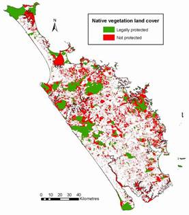
Map: Remaining native vegetation cover in Northland
In total, 13.75% of Northland's terrestrial environment has some form of legal protection. This equates to 180,336.2 hectares (ha) of land. Of this total, 92% (156,451 ha) is designated as a PNA and therefore is protected with the aim of conserving natural values. The remainder is protected as a by-product of another designation, for example, Recreation Reserve.
Within the PNA programme, each region is divided into Ecological Districts – a local part of New Zealand where topographical, geological, climatic, soil and biological features produce a characteristic landscape – and Ecological Regions – a collection of closely related ecological districts. Northland comprises 24 ecological districts and seven ecological regions.
Ecological districts have been closely analysed to determine the percentage of land area in each that is acutely or chronically threatened (Priority One). The area of threatened habitat varies considerably between ecological districts, for example, 51% of Pouto is considered to be highly threatened but only 0.8% of Te Paki is in the same class. In the Northland region, only 1.7% of acutely threatened and 4.2% of chronically threatened habitat is protected.
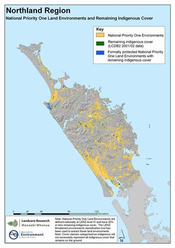
Map: National Priority One habitats in Northland
19 of Northland's 24 ecological districts have been fully or partially surveyed. To date, a total of 1320 NAES have been identified in the region. Of this number, 38% (506 areas) receive some legal protection by one of the mechanisms already mentioned, i.e. the PNA programme. However only 2% of NAES have their total land area protected. 62% of NAES are not protected or managed by any mechanism.
As can be seen from these figures, the majority of identified priority one habitat and NAES in Northland have no formal protection. In addition, a significant proportion of the region has not yet been surveyed so we do not know the ecological value of this land. Of those sites that do have legal protection, the standards of care (i.e., the management of the site) vary greatly between sites. Management depends on ownership, management goals, available funding and resources. There are no minimum standards of care for PNAs and as such, some may be inappropriately managed for the biodiversity values they are trying to conserve.
The key recommendations from the report are as follows:
· Complete ecological surveys of all ecological districts in Northland through the PNA programme;
· Investigate whether or not legal protection is required for all NAES and areas of threatened (Priority One) habitat that have no, or only partial, legal protection;
· Develop minimum standards of care for PNAs and other special sites, such as NAES;
· Prevent further clearance, modification or disruption to remaining areas of significant and threatened habitat;
· Work with landowners to protect features identified as National Priority or NAES, where these have been identified, through sustainable management and environmental awareness;
· Target funding towards areas identified as National Priority habitat or NAES; and
· Ensure that the current GIS database of PNAs and NAES is maintained and updated.
Priority Habitat Monitoring
Over the last 160 years of European settlement in Northland, approximately 95% of wetland habitat has been lost through drainage, clearance or modification. It is estimated that 5% of the original area of wetland habitat remains, however there are no accurate figures to confirm this and there has not yet been a comprehensive ground survey. Only around one third of freshwater wetlands in the region are protected by formal mechanisms, for example reserves or covenants.
Landcover Database 2 (LCDB2), which is based on satellite imagery, shows 7164.5 ha of freshwater wetland in the region. This does not include saltmarsh or some of the seasonally dry wetland types, such as floodplain forest and gumlands. Wetlands visible on aerial photographs or from roads have been mapped as part of the Department of Conservation's (DOC) Protected Natural Areas Programme (PNAP) but many of the smaller wetlands have been missed and some survey work is more than 10 years old so may already be out of date.
Wetlands in Northland fall into several different types, each with its own special plant and animal community. The most common wetlands are the higher fertility swamps which are characterised by raupo. The rarest wetlands are the low fertility bogs and fens, which are characterised by sphagnum moss and baumea sedges. Flax swamps, once common in the region, now occupy less than 170ha, of which only 25% is protected. Another much reduced wetland type is gumland which, although dry for much of the year, is classed as a wetland because it has poorly drained soils which waterlog during the winter.
Land-use intensification, increasing levels of subdivision and environmental incidents all increase the pressure on the remaining areas of wetland in Northland. Wetlands are impacted by:
· increased stocking levels and grazing of wetlands;
· drainage and conversion to pasture;
· nutrient inputs due to increased use of fertiliser on surrounding pasture;
· lowering of water levels from land drainage/land use leading to colonisation by pest plants;
· land use changes e.g. increased cropping of lowlands, horticulture on gumlands; and
· subdivision - storm water runoff, culverts, roading, drainage, infilling and clearance
During the 2007-08 financial year, NRC staff began a project to survey and map all important wetland habitats in Northland and record these findings in a new wetlands database. Field staff visited a number of wetland habitats on private land and assessed and ranked these according to their ecological value. Roadside surveys were also undertaken where access could not be gained. Data collected was then entered into the wetlands database, which is contained under a wider biodiversity database. Over 200 records were added to the database in 2007-08.
Over time, all wetland information collected by the Department of Conservation (DOC) from its PNAP surveys will also be added to the database. Once complete, the database will be used to compile a list of Northland's top wetlands. From this list, it will be possible to identify important wetlands that are currently unprotected and unmanaged and so target funding and assistance towards these. The database also identifies wetlands ranked as ‘regionally significant'. These wetlands must be considered in the planning process, resource consent applications and during environmental incidents.
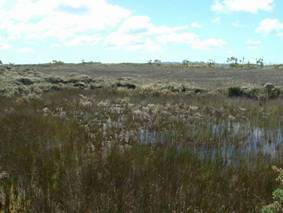
Photo: Peat bog on the Karikari Peninsula, one of the rarest types of wetland in Northland
Threatened Species Monitoring
According to a national threat review of native seed plants and ferns, Northland (at 57) has the third highest number of acutely threatened species of any region in New Zealand, behind Southland with 67 and Canterbury at 65.
Numbers of acutely threatened species have increased nationally from 122 to 177 in the last five years. It is important that species on the list are monitored on a regular basis and accurate records kept in order to monitor change over time. NRC has contributed more than 25 of the threatened species site records (both new and repeat records) to a national database maintained by DoC
NRC has worked with DOC and Auckland Museum botanists to assess and rank every native plant species known from Northland. From this, a draft list of plants which are rare or regionally significant has been developed. This list includes plants which are both ‘nationally threatened', as well as plants which may be common elsewhere but which are rare in Northland. The list will be sent out for public comment and the final document will be used to help guide landowners and agencies in biodiversity conservation and planning matters. The draft list is already being used by Whangarei District Council in consideration of covenants and subdivision applications.
The photograph below shows one of New Zealand's rarest plants, the native hibiscus (Hibiscus richardsonii) rediscovered by council staff near Kamo recently. This plant is listed as Nationally Critical and is only found in a few Northland sites.
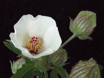
Photo: The ‘Nationally Critical' plant Hibiscus richardsonii
Biodiversity Management
NRC owns 523 hectares (ha) of land on Mount Tiger Road, east of Whangarei, called Mount Tiger Forest. The land is primarily Radiata pine production forest, however 160 ha of the land comprises indigenous vegetation, which has high ecological, cultural and social value. NRC is currently developing a "best practice" sustainable forest management plan for the site that will support continued economic use of the pine, whilst maintaining, conserving and enhancing the values of the native forest.
In terms of biodiversity value, the native forest comprises a variety of habitat types (such as broad leaf forest and freshwater streams), which means that it supports a large variety of plant and animal species. Habitats present include tracts of Kauri forest, which are significant given their size in relation to proximity to Whangarei city. The native forest supports many native bird species, including the New Zealand Pigeon (Kereru), which is declining in numbers nationally. Areas of freshwater support high numbers of Freshwater Crayfish (koura).
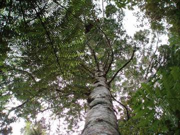
Photo: Kauri and Punga in Mount Tiger Forest
Mount Tiger Forest forms part of a mosaic of habitats within the Whangarei area. There are 11 conservation blocks within 10km of the site, all islands of native vegetation within development or farmland. These ‘islands' are an important refuge for plant and animal species. Within a mosaic landscape such as this, small remnants of native forest such as Mount Tiger are extremely valuable and act as a stepping stone for plant and animal species between remaining areas of native vegetation.
Intensive possum control work has already been undertaken in the forest and this work will continue into the future. In addition, environmental weeds such as wild ginger and mothplant are targeted for eradication. Future management of the site by NRC will focus on sustainable forestry management.
Sustainable forestry management means sustainable yield of product coupled with sustainable use of the forest for multiple uses, such as conservation. Management of this area will include a continued pest control programme to manage pests such as possums and wild goats, which impact on plantation and native forest health, continued protection of significant archaeological and spiritual sites within the forest. The aim is to provide an example to other landowners in Northland of how a production forest can be managed for economic, cultural and ecological gain.
The Regional Council's current policy is that owing to the need to protect its commercial investment and mitigate risks around fire and health and safety, NRC will not be providing formalised public access to the forest.
Community and Landowner initiatives
The NRC Environment Fund has provided over $2 million to help people improve and protect Northland's natural environment since 1996. The fund is contestable and is open to individuals and voluntary groups with eligible projects on private land. Most projects are funded at 50% of their total cost. Projects must be of long-term benefit to the local environment and show evidence of good resource management.
During 2007-08, a total of $520,000 was allocated to approximately 150 environmental projects involving landowners and community groups. Examples of projects receiving funding include forest restoration, wetland protection, pest control, revegetation or coastal stock exclusion. Several projects helped landowners to fulfil the targets contained in the "Dairying and Clean Streams Accord". For more information on the Accord, go to: www.nrc.govt.nz/streamsaccord
During 2007-08, Council staff also provided technical advice and support for a number of restoration, protection and replanting projects, many of which were supported by the Environment Fund. NRC staff were also active in advocating protection of biodiversity at field days and shows during the year, including a biodiversity field day held at Matapouri that was attended by approximately 300 people.
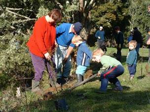
Photo: A community replanting project funded by the Environment Fund
In the 2007-08 financial year (July – June), Council staff participated in a number of assessments for proposed QEII covenants. QEII covenants are a legally binding protection agreement, which is registered on the title of the land. It is voluntary but once in place binds the current and all subsequent landowners. Each covenant is unique and contains different conditions and management areas depending on the biodiversity being protected. NRC staff also undertook assessments of significant indigenous vegetation contained within areas proposed for subdivision in order to predict the ecological impact of the development on biodiversity.
Enquiries from the general public relating to biodiversity are an indicator of increasing awareness and concern about environmental issues. A total of 63 enquiries relating to biodiversity were recorded in 2007-08.