Case Study Three: A stormy, wet autumn and cold, early winter
March 2006
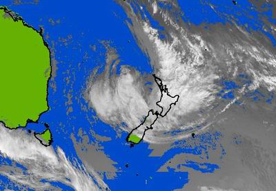
March rainfall amounts varied from average in the southern parts of Northland to 97% above average in the eastern hills at Puhipuhi. The MetService issued two severe weather warnings for Northland during March, on 7 and 26 March. The latter resulted from a deep depression associated with the remnants of Cyclone Wati (shown in the satellite image below taken at 1pm on 26 March). Strong north easterly winds (up to 140 km/hr recorded at Cape Reinga) brought consistent, heavy rain to the Northland region over two days. The maximum recorded total for the two day period was 191 mm at the Council's Puhipuhi telemetry station. No flooding eventuated from either rainfall event. As a precaution, on 27 March, warnings of high river levels were issued to residents in the lower flood plains of the Mangakahia, Wairua and Northern Wairoa (Tangiteroria) Rivers. Most river flows were near or above their normal flows for this time of year.
April 2006
Northland experienced a very wet April, with rainfall amounts well above average. Rain fell, on average, over 22 days during April, with heavy rain recorded early, mid and late April. Typically river flows were significantly above their normal April flows.
On 24 and 25 April isolated, intense rainfall was recorded in the far north areas around Kaeo and Kaikohe. Kaeo received 90 to 112 mm over a 6 hour period with maximum hourly intensities of 34 mm/hr. More rain fell over the high altitude areas in the Puketi Forest causing water levels in the Waipapa River to reach 5.1 metres at midnight on 24 April. Serious flooding resulted at Rangiahua where flood waters crossed SH1. Kaeo Township was also affected by flood waters from the Kaeo River extending over SH10 at Kaeo. Flood warnings were issued for the Mangakahia, Wairua and Northern Wairoa River catchments. The MetService did not issue a severe weather warning for this event.
From 27 April to 2 May the MetService issued a series of severe weather watches and warnings for Northland (including the greater part of the North Island). These warnings were issued as a result of a large, deep depression which had remained relatively stationary in the mid Tasman Sea. A series of fronts accompanied with moist, warm air was expected to generate intense thunderstorm activity as this depression moved across New Zealand. These events were closely monitored while each front moved over Northland. Intense, thunderstorm activity and heavy rain was recorded at isolated areas throughout the region. For example, on 27 April, 55 mm was recorded in 45 minutes at the council's rainfall station at Maungaturoto and an hour later 30 mm was recorded over one hour. At Paparoa, only 7 kilometres to the west of Maungaturoto, the total rain recorded for the same period was only 23 mm. No serious flooding was reported from these isolated events.
May 2006
Rain fell, on average, over 22 days during May, similarly to April. Rainfall amounts varied from 110 mm at Dargaville to 407 mm in the eastern hills north of Hikurangi. On 22 May a northerly front produced intense rain of up to 25 mm/hr. The front became stationary over an area from the Bay of Islands to Maungaturoto. During this period over 170 mm was recorded in the Glenbervie Hills and 120 mm at Puhipuhi. Other areas of Northland received 20 to 50 mm during this event. The heavy rain caused extensive surface flooding south of Kawakawa and the elevated river levels in the Mangakahia and Wairua Rivers resulted in flooding of low lying floodplains. On 26 May a larger band of rain resulted in widespread rain over the eastern parts of Northland. Rainfall amounts of 70 to 80 mm were recorded along the eastern hills from Kerikeri to Whangarei while remaining areas of the region received 20 to 40 mm. Typically river flows and ground water levels were higher than normal for May.
June 2006
In contrast to April and May, rainfall amounts recorded over Northland during June were generally low, although some western areas near Dargaville and the high altitude areas of the Waima Range recorded near average rainfall amounts. The larger part of the region received 40 to 80% of the expected June rainfall, with the lowest rainfall recorded in the eastern area from Kaeo to Whangarei (40 to 60%). Low river flows were recorded in eastern areas, varying from 58% in the Wairua River to 68% in the Mangaparerua Stream west of Kerikeri. Patches of heavy isolated rain resulted in average river flows in the Waitangi, Waipapa, Kaihu and Ahuroa Rivers.
According to the NIWA climate summary for June, "Anticyclones (highs) were much more frequent than average during June in the Australian Bight with ridges of high pressure extending into the south Tasman Sea. This pattern resulted in frequent cold southerly winds over New Zealand." From the NIWA June statistics, Kerikeri recorded the second lowest mean air temperature for June since records began in 1982, of 10.4ºC, while Whangarei recorded the second lowest since 1968, of 10.7ºC. Although cold, sunshine hours were well above normal, for example, Dargaville recorded 150 hours; the highest recorded since 1943.