Living in the coastal hazard zone
Within this section…
Case Study: The September 2005 Storm
During 18 - 19 September 2005 large perigean-spring tides coincided with a moderately-intense low-pressure weather system, which brought strong winds. The tide height at Port Taranaki was predicted to be 3.9 metres, where as Mean High Water Spring is 3.5 metres at Port Taranaki. Barometric pressure in Dargaville was recorded as 983 hPa, compared with a mean pressure of 1014 hPa. Strong winds were recorded with mean peak winds of 48 km/hr and a maximum wind gust of 105 km/hr.
The low pressure and wind forcing caused a moderate storm surge setup which caused localised inundation and erosion at a number of, predominantly west coast, locations.
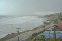
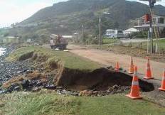
Substantial erosion occurred to the Ahipara foreshore north of the Wairoa Stream, with erosion of between 5 - 10 metres. Localised coastal inundation also caused temporary flooding of the road and low-lying properties. The photographs below shows Ahipara during the storm (left) and an area affected by inundation and erosion (right).
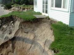
Substantial erosion also affected the Omapere foreshore, with differential erosion of between 1 - 4 metres on average along most of the Omapere foreshore. At least one dwelling was put at direct risk from this event with the concrete foundation overhanging the edge of the eroded dune scarp, as shown in the photograph below.
The east coast settlements were less affected by this low-pressure weather system due to the lower wave energy on the east coast. Nevertheless, there were some localised effects, including the failure of the Pyle Road seawall at One Tree Point, Whangarei Harbour. Some erosion also occurred at the Rangiputa shoreline, as result of this embayed east coast settlement's westerly facing aspect.
So what is the Council doing about it?
Following the storm several meetings were organised with local communities that were concerned and/or affected by the consequences of the event.
A public meeting, organised by the NRC, was held in Omapere on 25 October 2005 to discuss the erosion of the Omapere foreshore and management options and issues. The meeting was well attended by a representative cross section of 80 people from the local community. A presentation outlining what we know about the Omapere Beach system, examples of management options, including pros and cons of each, an explanation of rules and regulations was given and attendees were invited to discuss ‘where to from here' with management of the beach. The community voiced a number of differing opinions as to what management actions should be implemented. From this meeting a Society, comprised mostly of local community members, was setup to consider options for managing the erosion of the Omapere foreshore. The Society has continued to meet on a regular basis, with support from the NRC, and is currently in the position of investigating the most appropriate short-term and long-term management options for the foreshore.
A similar meeting, although on a smaller scale, was held at Ahipara on 18 October to discuss management options for those properties affected by erosion near the Wairoa Stream. The meeting was well attended by the affected beachfront property owners. The outcome from the meeting was that the affected beachfront community wish to implement a ‘low impact' solution to the erosion, with also some consideration to the reconstruction of a groyne to train the river. The NRC has continued to liaise with a number of the affected property owners over the management of the foreshore in this area, with initial management options currently being considered.