Introduction
One of Northland's most treasured natural resources is our expansive, diverse and beautiful coastline, over 3000 kilometres in total. The Northland Regional Council produced a Regional Coastal Plan, which became operative in 2004. This plan outlines the rules and regulations regarding what people may and may not do, in terms of activities that can have an impact on coastal areas.
As our coastline is so large and valued it is not surprising that the Northland Regional Council carries out a considerable amount of coastal monitoring in a range of areas such as:
- recreational beach bathing quality
- recreational shellfish water quality
- estuarine monitoring
- coastal hazard monitoring
- beach profile monitoring
- implementation of a coast care programme.
Check out the performance targets to find out which community outcomes in the Long Term Council Community Plan relate to coastal monitoring.
Recreational bathing water quality
In 2005-06, 58 coastal sites were monitored for 12 weeks over summer for the recreational bathing water quality monitoring programme to assess the suitability of water quality for recreational use. In general, water quality in most of Northland's nearshore coastal waters comply with microbial water quality guidelines for recreational use. However, following heavy rainfall water quality tends to decline in some areas and can remain compromised for several days. At open coast locations water quality tends to be less affected by rainfall than that at estuarine or harbour locations, where contaminants may become concentrated under conditions of limited tidal flushing.
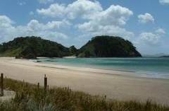 Matapouri Beach.
Recreational shellfish gathering water quality
Concurrently to the recreational bathing programme samples from 17 sites were also analysed to assess recreational shellfish gathering water quality. The water quality at most areas sampled did not comply with the water quality guidelines for recreational shellfish gathering, with the exception of Ruakaka near surf club, Waitangi Bridge, Te Haumi River and Taipa. These results are indicative only, as samples were only collected for 12 weeks in summer from the water in recreational gathering areas not the shellfish themselves. However it does give us a good idea of the potential risks in Northland for recreational shellfish gatherers.
Resurvey for antifouling co-biocides
In February 2006 the Regional Council assisted with a Ministry for the Environment project which involved resurveying for antifouling co-biocides at selected sites in Northland. This followed on from the 2003 national survey. Measurable concentrations of the co-biocide Diuron was found at sites of high density moorings, while there was no Irgarol 1051 detected at the selected sites in Northland.
Estuarine monitoring programme
In 2005-06 the coastal team implemented the Estuarine Monitoring Programme, using the national Estuarine Monitoring protocols, in Whangarei Harbour and Ruakaka Estuary. This involved monitoring of both fine and broad scale habitat characteristics such as faunal and floral composition, nutrient sampling, sediment particle size and the proportion of different habitat types including substrate type and vegetation cover. Results indicate that both estuaries are moderately enriched with low to moderate microalgal mat development. Sand was the dominant substrate for both estuaries, while faunal and floral abundance and extent was relatively variable for the two estuaries.
Tsunami hazard
With over 3000 kilometres of coastline and 30 coastal settlements, Northland's exposure to tsunami hazard is high. However, there are several critical unknowns about tsunami hazard such as the record of historic/pre-historic events and significance of tsunami generating sources. In 2005-06 a comprehensive literature review of the historic tsunami record for the Northland region and a ground truthing field assessment of representative sections of the Northland coastline, with sediment coring in selected areas, were undertaken by National Institute of Water and Atmospheric Research (NIWA) staff with contributions from ArchResearch and the Regional Council.
Beach profile monitoring
The beach-profile monitoring programme was continued in 2005-06 to provide information on the positional stability (i.e. eroding, equilibrium, accreting) of the foreshore and foredune at selected coastal areas. For the majority of east coast sites, results tend to indicate that foredunes have continued to accrete sand and grow seaward under the existence of favourable ‘dune building' conditions, which have tended to dominate since the easterly storms in July 2000. The exception is those areas where historically the foredune complex has been extensively modified and native foredune vegetation removed. A storm event in September 2005 affected several coastal areas in Northland.
Coast Care
In response to increased pressure from coastal development, hazard management issues and the establishment of coast care groups, the Northland Regional Council has sought to develop a coast care programme. The aim of this programme is to enable communities to better understand coastal processes and initiate protection, restoration and enhancement of dune ecosystems through the establishment and resourcing of community based coast care groups. The photograph below demonstrates the damage humans can have on coastal dunes showing vehicle damage to dunes on the West Coast.
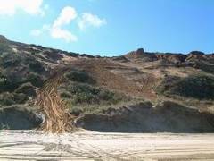 Photo of coastal dune damage from vehicles on Northland's west coast.