Specific Groundwater Investigations
Within this section…
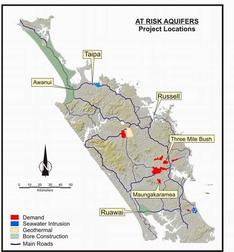
In addition to the routine monitoring carried out as part of the networks mentioned in the groundwater quality section, specific groundwater monitoring projects have been carried out in the Ruawai, Taipa and Russell areas to investigate areas of concern identified in previous monitoring. These investigations also provide better information to the Regional Council to ensure the sustainable management of these groundwater resources, particularly where information is lacking. The map below shows the location of ‘At risk aquifers' in Northland, of which three were covered by these specific investigations and the other three had hydro-geological surveys carried out on them in 2005-06. Also age testing of groundwater was carried out in five bores in 2005-2006, as the age of groundwater can have significant management implications.
Ruawai Groundwater Monitoring
The Ruawai area, located approximately 15 kilometres south of Dargaville, is predominantly an alluvial flood plain consisting mainly of mud, sands and peat. The Northern Wairoa River bounds the area to the west and south, and limestone hills mark the northern and eastern boundaries. The flood plain is heavily drained. The main land uses in the area are horticulture (particularly kumara growing) and agriculture (such as dairy farming).
Historical bore logs in the area indicate groundwater is present across the flood plain at varying depths and quality. Groundwater in the Ruawai area is important as most local surface water has a high salt content and it is principally used for irrigation, stock water requirements and public water supply.
The main groundwater issues in the area are the potential for:
- intensive horticulture and agricultural activities to degrade water quality; and
- groundwater abstractions resulting in saline (saltwater) intrusion.
At present six bores are sampled monthly for a range of parameters to determine long term and seasonal variations in groundwater levels and quality, to ensure the sustainable management of the groundwater resource.
The results of sampling over the past year are consistent with the findings of the 2004-2005 sampling, which indicated elevated chloride and sodium concentrations in the south-eastern and northern boundaries of the groundwater system. These results suggest that saltwater intrusion is occurring in the south-eastern and northern zones of the Ruawai aquifer, however, this is not influencing the water quality in the western zone at the site of the Kaipara District Council pubic water supply bores. Monitoring will continue next financial year.
Taipa Groundwater Monitoring
Taipa is a coastal aquifer with a saline boundary on the northern and eastern edge of the aquifer. The main source of recharge is rainfall. The Taipa aquifer has similar groundwater issues to Ruawai, including potential for degraded water quality and saline intrusion. Four bores are sampled monthly and analysed for nitrate and saline indicators such as chloride.
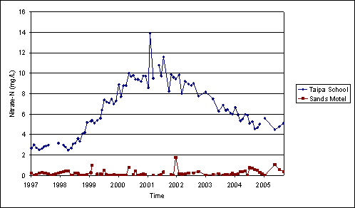
The results from this monitoring indicate elevated nitrate levels in a number of bores in the Taipa settlement area. The results from 1997 to June 2006 are shown in the graph below for two bores, Taipa School and Sands Motel. Nitrate levels in groundwater from the Taipa School bore exceeded the drinking water limit of 11.3 mg/L on several occasions in 2001-2002. However levels had dropped below the drinking water standard by May 2002 and have continued to decline. The school does not use groundwater from the bore for drinking. Nitrate levels in groundwater from the Sands Motel bore have been slightly elevated particularly over the last year but remain well under the drinking water limit.
Chloride levels in the bores adjacent to the foreshore have shown no significant variation over the monitoring period. On going monitoring of the nitrate and chloride levels in the Taipa groundwater will continue, however the frequency of monitoring will be reduced.
Russell Groundwater Monitoring
Russell groundwater resource consists of a gravel and fractured greywacke system in close proximity to the coast. The main sources of recharge to the system are rainfall and onsite wastewater discharges. There are many bores in the area that abstract water for domestic use. The main concern for the Russell aquifer is that reduced recharge due to wastewater reticulation and increased groundwater use will lead to an increased risk of saline (saltwater) intrusion. Previous groundwater modelling suggests that the reticulation of wastewater will significantly increase the risk of saltwater contamination of the Russell groundwater resource during prolong dry periods.
There are currently four monitoring bores in Russell and Matauwhi Bay. Two of these bores are sampled and analysed for saline indicators on a monthly basis. The other two bores are sampled quarterly for a range of determinants and bacteria.
One bore on the Russell foreshore regularly records groundwater level and conductivity. A telemetry system has been installed to enable direct telephone access to these monitoring results, and therefore enable an early warning of any increase in saltwater contamination in the aquifer. Estimation of the depth to the saltwater interface and the conductivity results for the telemetered bore suggest that either this bore needs to be deepened or a new monitoring bore installed closer to the foreshore to provide for warning of saline contamination. This work will be undertaken during 2006-07. Monitoring in Russell will continue next financial year.
Age testing
The age of groundwater has important implications for management of groundwater resources in Northland. For example, if the age of groundwater in a particular aquifer is found to be approximately 50 years, then water quality now is a result of land use 50 years ago. However there is always a recent component such as bacterial contamination.
During 2005-06 five water samples were collected and analysed to determine the average age of the groundwater (mean residence time) delivered from bores in the Northland region. Samples were collected from groundwater quality monitoring bores at Maungakaramea, Mangawhai, Whatitiri, Three Mile Bush and Matapouri and analysed for tritium, CFC and SF6 isotopes.
The initial age estimates are provided below, however, further analysis is required and the bores will be resampled in approximately five years, to ensure accurate interpretation of the results.
| Site of bore |
Initial Mean Residence Time Estimate (years) |
| Mangawhai | 3 ± 3 |
| Whatitiri | 3 or 45 |
| Maungakaramea | 45 ± 3 |
| Three Mile Bush | 50 ± 3 |
| Matapouri | 40 ± 3 |
The relatively old age recorded in the Matapouri bore may indicate the sand aquifer is recharged by relatively old water from the surrounding greywacke. The analysis for the Whatitiri sample indicated two possible ages (3 or 45). However due to the depth and geology of the Whatitiri bore the mean residence time is likely to be around 45 years. However, additional sampling and analysis will be required to confirm this.