October 2023 climate report
6 Nov 2023, 2:45 PM
Summary
- El Niño Southern Oscillation (ENSO) has a 100% chance of continuing through the summer.
- Temperatures are likely to be “above average” while rainfall will be “below average” between November and January.
- Rainfall in Northland was 156% of the expected October totals. This was driven by Ex-TC Lola at the end of the month.
- Standardised precipitation of rainfall in Northland is near normal for between August – October, however it is beginning to drift towards being drier than expected.
- October river flows were highly variable, with no discernible pattern for “above normal” or “below normal" flows.
- Ground water levels in the aquifers between Whangārei and Taipa “below normal” for October.
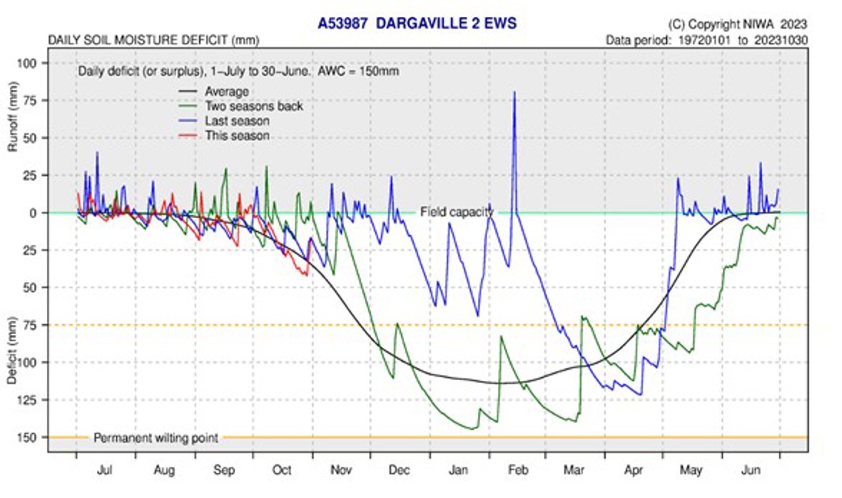
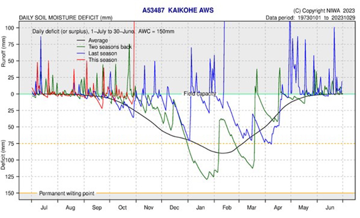
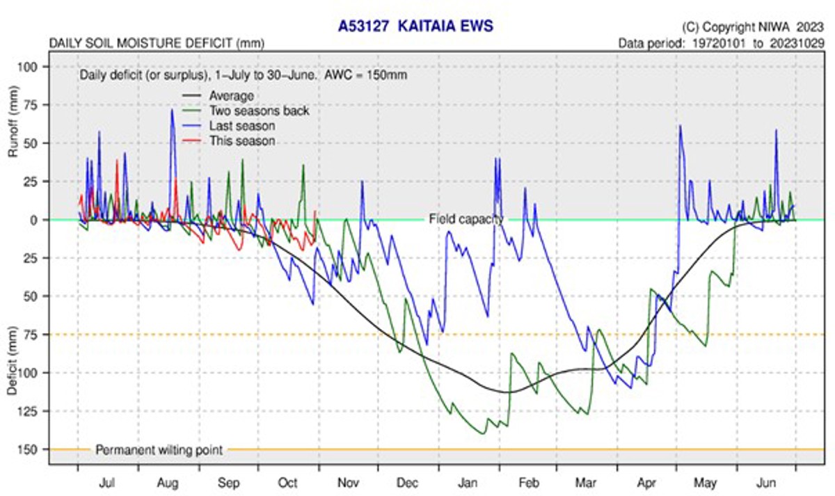
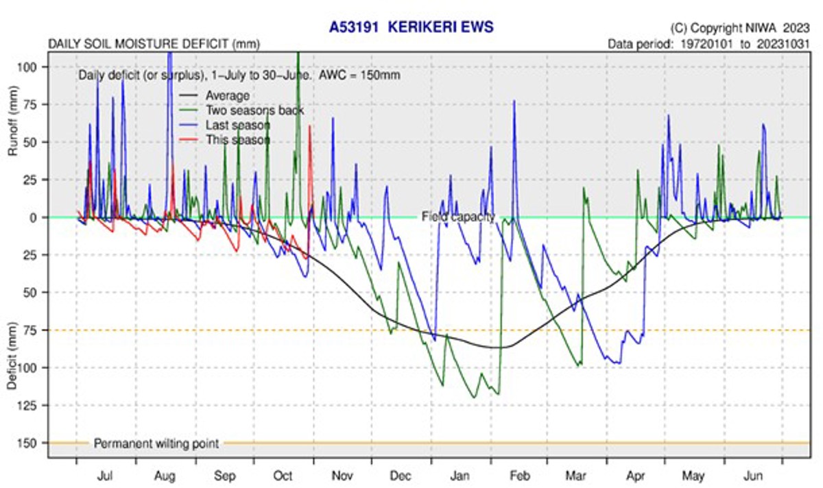
- Soil moisture levels generally declined through October before being recharged during Ex-TC Lola. The east coast and centre of Northland is at field capacity while the west has a mild deficit.
Climate Outlook
November 2023 to January 2024
El Niño conditions are currently tracking to be a highly significant event, with the October conditions recorded in the Pacific being the strongest since 1998. There is a 100% chance that El Niño will drive the summer climate, and an 80% chance that the conditions will persist throughout autumn. El Niño is expected to peak in December or January.
The Indian Ocean Dipole continues to be in a positive phase, which forces more high-pressure systems to congregate around New Zealand. This means Ex-Tropical Cyclones are less likely to pass over New Zealand. Northland can expect above average temperatures for the November – January period, and below average rainfall. River flows and soil moisture are likely to be near average or below average. Localised marine heat waves are likely to occur around Northland.
For more details, please refer to NIWA’s seasonal climate outlook for November 2023 - January 2024:
See the seasonal climate outlook on NIWA's website: niwa.co.nz
NIWA Temperature, Rainfall, Soil Moisture and River Flows probabilities for the period of November 2023 to January 2024
(Expressed as % likelihood for either Above Average, Near Average or Below Average conditions).
| Temperature | Rainfall | Soil moisture | River flows | |
| Above average | 50• | 20 | 15 | 15 |
| Near average | 40 | 30 | 40• | 40• |
| Below average | 10 | 50• | 45• | 45• |
Rainfall
Majority of October was drier than expected, with small, scattered showers periodically passing through the region. However Ex-tropical cyclone Lola brought high winds and in excess of 100 mm of rain to most areas of Northland between 28 – 31 October. The rainfall from ex-TC Lola, is the driving factor for bringing the rainfall accumulated for the Hydrological year (July – June) close to the expected October average.
The highest rainfall amounts for October were in the central areas and the east coast. Kaikohe recorded the most rain (302.4 mm) followed closely by Whakapara (298.5 mm) and Touwai/ Whangaroa area (272 mm). The lowest recorded rainfall was on the Poutō Peninsula, with Poutō Point recording 42.5 mm, and Ngatawhiti Road, part way up the peninsula recording 68.5 mm.
The region on average recorded 147.25 mm. By percentage Northland received 156% of the expected rainfall for October. Ōpua received 320%, followed by Wiroa Road, west of Kerikeri with 319%. While Poutō Point had the lowest on 62% followed by Dargaville with 78%.
Rainfall (% of Median) for October 2023 across Northland with a range of 320% to 62%
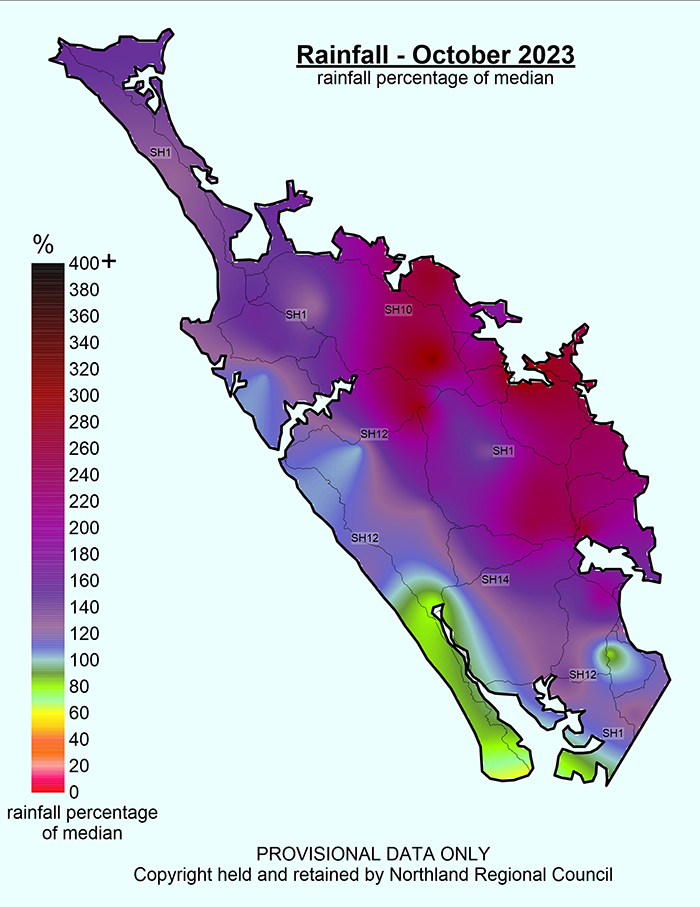
Rainfall (% of Median) for October 2023 across Northland with a range of 320% to 62%.
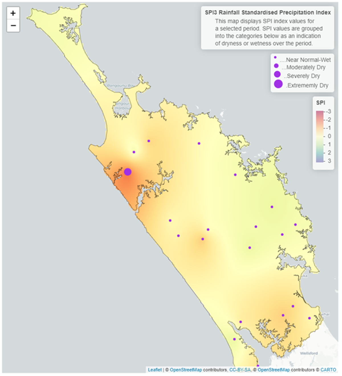
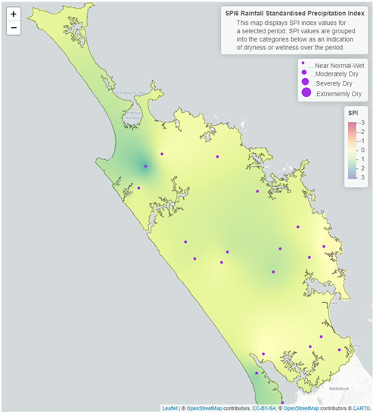
Standardised Precipitation index (SPI)
The Standardised Precipitation Index (SPI) on a three-month scale shows that all of Northland has been “near normal”, with some areas “moderately dry”. This has been driven by the wetter than usual October after Ex-TC Lola, while August and September were drier than average. On a six-month scale between May – October 2023, the standardised rainfall averages Northland to be “near normal – wet”, with the Kaitaia area and Poutō peninsula being comparatively the wettest areas of Northland.
3-month (August-October 2023) and 6-month (May-October 2023) SPI maps
River flow
River flows varied across Northland during October, with most catchments ranging between “above normal”, “normal” or “below normal”. There is no discernible pattern matching rainfall or other factors for the average October flows.
The Waitangi and surrounding catchments are however recording “low” flows than expected for October.
Monthly percentile River Flows for October 2023
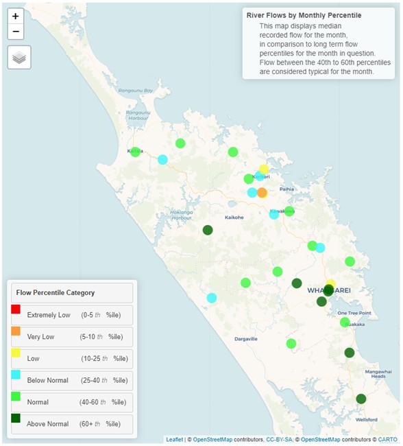
Monthly percentile River Flows for October 2023.
Groundwater
Water levels in the far north and the south of Northland are currently recording “above normal” levels for October. While from Whangarei to Taipa the key aquifers are recording “below normal” or “low” water levels for October. There is some variation in bores within the same aquifers, which could relate to recovery times possibly from Ex TC Lola. The key aquifers give a good understanding of the general water levels going into to summer with El Niño.
| Aquifer | Status | Percentile |
| Aupōuri | Above normal | 60th+ |
| Taipā | Normal | 40th-60th |
| Russell | Normal | 40th-60th |
| Kaikohe | Low | 10th-25th |
| Poroti | Below normal | 25th-40th |
| Whangārei | Below normal | 25th-40th |
| Mangawhai | Above normal | 60th+ |
| Marsden - Ruakākā | Above normal | 60th+ |
| Ruawai | Above normal | 60th+ |
Groundwater levels for October 2023
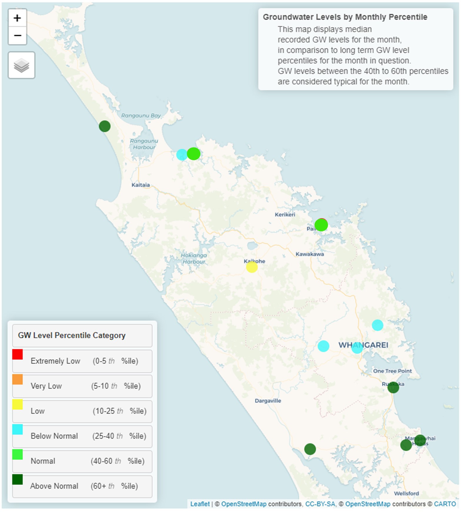
Map displaying groundwater levels by monthly percentile for October 2023.
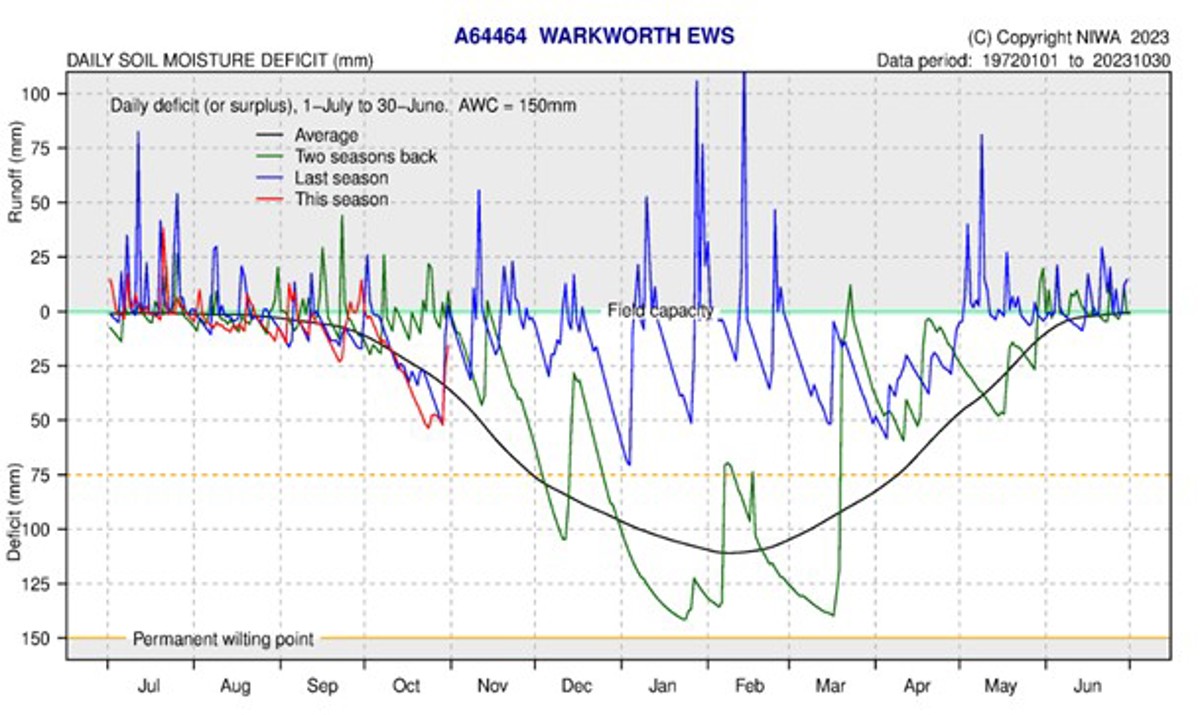
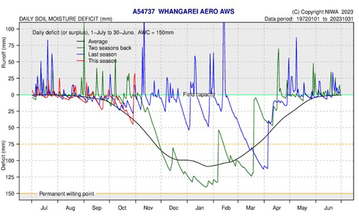
Soil Moisture
Soil water levels slowly dried out creating around at 25 mm deficit across Northland during October. However Ex-TC Lola caused a strong reversal in the central and eastern areas of Northland with over 100 mm of runoff calculated in Kaikohe, while Kerikeri and Whangārei calculated 25 – 50 mm of run off.
Other areas in the west or north of Northland also showed an increase in in soil water levels, to between 10 mm of deficit to reaching field capacity. The soil moisture deficit is calculated based on incoming daily rainfall (mm), outgoing daily potential evapotranspiration (mm), and a fixed available water capacity (the amount of water in the soil 'reservoir' that plants can use) of 150 mm” (NIWA).