14.3 What is the state of our soil and land resources?
Soil quality
Twenty-five sites around Northland, of varying land uses and soil types, were initially sampled in 2001 as part of the national 500 Soils project. The main objective of this project was to establish a national baseline against which future trends in soil quality could be measured. These 25 sites were resampled in June 2007 (Stevenson 2007). The results from the 2007 sampling are shown in tables 9, 10 and 11 in appendix A.
Chemical properties in 2007
In general the chemical properties of most sites were good and within the recommended range for the different land use and soil types, as shown in table 9 in appendix A. However Olsen phosphorus (Olsen P) and pH were outside target ranges for several sites. Olsen P, which is a measure of phosphorus available for pasture production, was below the target range for three of the 25 sites, all of which were drystock sites. This could be as a result of lower rates of fertiliser application. Soil pH was below the target range for two sites (both dairy) and above for two sites. The two pH levels below the target range could be due to higher nitrogen fertiliser application and/or increased soil compaction under heavier stocking regimes.
Physical properties in 2007
Approximately half of the 25 sites had values outside the target ranges for macroporosity, particularly on pasture (dairy and drystock) sites, indicating compacted soils, as shown in table 10 in appendix A. This is consistent with findings elsewhere in New Zealand where sites in pasture are showing moderate compaction. Greater caution is needed in Northland, as Northland soils are more susceptible to compaction due to their higher clay content and to a generally wet winter.
Heavy metals in 2007
The levels of heavy metals in the soil samples varied across land uses, with no obvious differences between land use categories, as shown in table 11 in appendix A. Natural levels of metals can vary depending on the parent geology of a site. All heavy metal concentrations were within the suggested soil limits of the New Zealand Water and Wastes Association (NZWWA 2003), except one site. The orchard site (NRC25) had copper levels of 102 mg/kg, just above the suggested limit for copper of 100 mg/kg.
Changes in soil quality since 2001
Macroporosity had decreased for many sites, particularly at dairy and drystock pastoral sites, which is generally a result of intensification of these land use practices. Mineralisable nitrogen values were also significantly lower at most sites in 2007 compared to 2001. Otherwise there were few changes consistent across land uses.
Overall the majority of instances of poor soil quality could be reversed by appropriate management. Landcare Research has recommended that sampling should continue to determine the extent and direction of any long term changes in soil quality. They also recommend increasing the number of sites, to gain more replicates for each different land use and to sample different soil types.
For more detailed information on the results from the 2007 sampling refer to the detailed report available on the Council website at the following link:
http://www.nrc.govt.nz/Resource-Library-Summary/Research-and-reports/Land-and-soils/
Land instability
Landslides can be a threat to life and property, with one fatality in Dargaville in 1998 and significant damage to property every year. In Northland the dominant trigger is intense or prolonged rainfall which initiates many landslides annually (Beetham et al. 2004). There are four main types of landslide hazards in Northland:
Debris avalanche
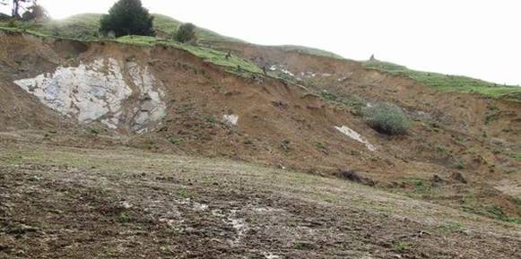
Many areas in Northland are susceptible to land instability of one form or another. The highest land within the region includes steep Tangihua volcanic ranges, such as Maungataniwha, Panguru, Waima and Tangihua Ranges. These, because of their steepness and exposure to high intensity short duration rainstorms, often suffer debris avalanches.
A debris avalanche is a slip containing a high proportion of water as well as logs, boulders and soil. It cuts a narrow path through surrounding forest and spill both into river systems and out onto surrounding land. This steep hill country is very susceptible to debris avalanches regardless of the health and extent of cover of native bush. Because a debris avalanche is likely to cut from the very top of a ridge to the valley floor, removing all bush in its path, it contributes large volumes of logs, boulders and sediment to river systems. Debris avalanches spilling down Mt Manaia in 1971 and the Panguru Range in 1999 destroyed buildings, roads and bridges in their path.
Because debris avalanches are unpredictable and very destructive, the only way of avoiding damage by debris avalanches is to avoid siting buildings or infrastructure in areas at risk.
Earth flows
The Waipoua and Tutumoe Plateaux is formed by a basalt flow (volcanic rock) capping and protecting softer underlying sandstone and mudstone. Water percolating through the volcanic rock filters through the more porous sandstone but is blocked by the mudstone. The water moves towards the edges of the plateau, seeping out along the interface between the two rock types and creating large landslides and earthflows on the middle slopes of the plateau. The movements occur in the Wekaweka valley and the catchments of the Otaua, Mangakahia, Tangowahine, Awakino and Kaihu Rivers are large enough to be recorded on the IGNS landslides database.
These movements are examples of geological erosion and while they cannot be prevented, they can be identified and avoided when siting roads, dwellings and infrastructure. The rate of movement on some can be slowed by planting deep-rooted trees and by strategic drainage.
Greywacke slips
The greywacke hill country extending down the eastern side of Northland from Whangaroa to Mangawhai is susceptible to slipping on slopes over 12o (Professor Brothers, Auckland University, pers. comm.). The soil, 1 to 2 metres deep, overlies a weather rock or regolith. Water percolating through the soil transports clay and deposits it as a layer on top of the regolith, creating a slip plane. During extended periods of wet weather the soil becomes waterlogged and can move down the slope over the slip plane. This movement, in which the soil surface remains relatively intact, is evidenced by terracettes or a folded surface. In high intensity, short duration storms, the saturated soil slides off the slip plane resulting in widespread but usually shallow slips. Again, slipping occurs in high intensity storms almost regardless of the vegetative cover.
More susceptible sites can be identified using aerial photography and land resource inventory mapping. Strategic planting of deep-rooted trees on these more susceptible sites can reduce the incidence and extent of slipping. Careful siting of infrastructure and suitable dewatering and stabilisation of susceptible sites can reduce the damage caused by this slipping, both onsite and offsite (in respect of water quality).
Unstable mudstone
The Northland Allochthon swept a mass of crushed and soft rock over middle and western Northland from the North Hokianga to Kaiwaka, extending to the east coast around Whangarei Harbour. This material is very unstable, particularly where there are complexes of sandstone, mudstone and limestone and is susceptible to deep-seated earthflows and slumping, as well as surface erosion forms like gully erosion. This soft, crushed and moving material is one of the reasons for Northland's winding and poorly surfaced roads. Examples of the effect of particularly difficult road foundations can be seen on SH1 immediately south of Kaiwaka and at Umawera, and on SH14 between Kirikopuni and Tangowahine.
Again, identification of these areas of soft, crushed, and folded rock is very important when planning infrastructure. Remote sensing survey methods which penetrate the surface of the earth, commonly used to search for minerals, would provide valuable data. Once identified, the difficult sites could either be avoided, or extra measures including drainage and pre-stabilisation, could be used to reduce the rate of movement. Strategic planting of deep-rooted trees could also assist stability.
Land use on erosion prone land
 Over half of Northland's land area (720,000 ha) is classed as erosion prone land (i.e. has a Land Use Capability (LUC) (Harmsworth 1996) erosion class of either 6e or 7e), as shown in table 6 and 7 (below). Almost half (43%) of this had indigenous vegetation cover in both 1997 and 2002, which with mature vegetation, has a low erosion risk. However 39% of the land classed as 6e, and 13% of the land classed as 7e, had pastoral land cover in 2002. Without careful management, appropriate soil conservation and erosion control methods, this land is at risk to erosion.
A significant portion of the erosion-prone land in Northland is also in pine forest. This land is most at risk to erosion during harvesting. Only a small area of the forestry on erosion prone land has been harvested since 1997.
Exotic forestry on Mount Tiger, Whangarei (above right).
There was little change in the proportion of different land uses on erosion prone land between 1997 and 2002.
Table 6: Area (ha) and proportion (%) of 6e erosion prone land (based on LUC) in different land uses in 1997 and 2002 (based on LCDB1 and 2). Afforestation - planted in forest for the first time.
1997 |
2002 |
||||
| 6e land (ha) | % of total | 6e land (ha) | % of total | Difference | |
| Afforestation | 16698 | 2.9 | 6334 | 1.1 | -1.80 |
| Indigenous vegetation | 236839 | 41.2 | 235576 | 41.0 | -0.22 |
| Forest harvested | 4237 | 0.7 | 7996 | 1.4 | 0.65 |
| Exotic vegetation | 6733 | 1.2 | 6623 | 1.2 | -0.02 |
| Pasture | 228582 | 39.8 | 223146 | 38.8 | -0.95 |
| Orchard/crops | 281 | 0.0 | 281 | 0.0 | 0.00 |
| Pine forest | 78724 | 13.7 | 92142 | 16.0 | 2.33 |
| Urban area/infrastructure | 752 | 0.1 | 750 | 0.1 | 0.00 |
| Other land covers | 2061 | 0.4 | 2057 | 0.4 | 0.00 |
| Total area | 574905 | 574905 | |||
Table 7: Area (ha) and proportion (%) of 7e erosion prone land (based on LUC) in different land uses in 1997 and 2002 (based on LCDB1 and 2). Afforestation - planted in forest for the first time.
1997 |
2002 |
||||
| 7e land (ha) | % of total | 7e land (ha) | % of total | Difference | |
| Afforestation | 4200 | 2.9 | 746 | 0.5 | -2.38 |
| Indigenous vegetation | 76426 | 52.6 | 76319 | 52.5 | -0.07 |
| Forest harvested | 1026 | 0.7 | 2147 | 1.5 | 0.77 |
| Exotic vegetation | 1374 | 0.9 | 1357 | 0.9 | -0.01 |
| Pasture | 20115 | 13.8 | 19509 | 13.4 | -0.42 |
| Orchard/crops | 24 | 0.0 | 24 | 0.0 | 0.00 |
| Pine forest | 37301 | 25.7 | 40410 | 27.8 | 2.14 |
| Urban area/infrastructure | 16 | 0.1 | 169 | 0.1 | 0.00 |
| Other land covers | 4738 | 3.3 | 4693 | 3.2 | -0.03 |
| Total area | 145374 | 145374 | |||
The need to get an economic return on farm investment, has led to a concentration of resource use on average to good pastoral land and the abandoning or selling off of more marginal land (Doug Foster, NRC, pers. comm.). This has had catchment-wide soil conservation benefits as this marginal land, which is often land classed as erosion prone, has either reverted to gorse or scrub or been planted in production forest.
Occurrence and extent of pest plants
Every year the Council reviews and produces an annual report on the Councils' performance towards implementing the annual Operational Plans prepared under section 85 of the Biosecurity Act.
Table 8 (below) presents the status in 2006-2007 of most of the pest plants included in the RPMS for Northland (NRC 2003), which was reported to the July 2007 meeting of the NRC Landcare Committee. In most cases the Council is well ahead or on target for meeting the objectives for each pest plant in the RPMS (NRC 2003).
Table 8: Occurrence and extent of major pest plants, including most plants from the Regional Pest Management Strategy for Northland, in Northland in 2006-2007
| Pest plant | Occurrence and extent in 2006 - 2007 |
| Manchurian ricegrass | · 76 sites throughout the region all outside the main infestation area are included in the control programme. · 16 of the 76 sites had no evidence of any regrowth. 42 sites had regrowth of less than 10% of the original infestation level. The remaining had regrowth of between 10% and 50%. |
| African feathergrass | · More than half of the sites had a clear status (33 of 63 sites had no new plants). · It is predicted that within four years over 90% of sites will be free of infestation. |
| Spartina | · Covers approximately 100 ha of Northland's harbours, however 80 ha is currently under active management. · Density is being reduced by approximately 80% per annum on all Mid and Far North sites. All spartina will be under management by the end of next year (2008), with all known sites either eradicated or remaining areas negligible in a further four years. |
| Lantana | · The continued control in urban centres (over 800 sites in 2006/07) is halting its spread, along with a targeted campaign to stop this pest plant reaching the Far North reserves. |
| Nassella tussock | · 39 properties are recorded as having nassella tussock with a total of 54 plants. This is an increase of 21 plants since 2005/2006. · 24 properties which have had nassella tussock controlled have remained clear for four years. |
| Evergreen buckthorn | · There is only one known site in Northland at Matakohe, which has been progressively reduced in size over the last 10 years and now covers about 1 ha. |
| Bathurst bur | · 81 sites were inspected by NRC staff at least once in 2007-2008 to ensure that property owners achieved complete control of all plants. |
| Nodding thistle | · 72 sites were inspected at least once during the year to ensure that property owners achieved complete control of all plants. |
| Californian thistle | · Five sites were inspected during 2006-2007. There are currently 24 known sites but new populations are continuing to be found. · While the infestation levels in Northland are low compared with other parts of New Zealand, Californian thistle can still rapidly invade open pasture and infest neighbouring clean farms if left uncontrolled. |
Spartina
A salt tolerant plant, spartina spreads mainly by underground rhizomes, bits of which break off when exposed by erosion on tidal stream banks or when grazing stock pull the whole plant out of the harbour sediment. It forms dense mats which act as sediment traps on exposed mud banks and under mangroves, catching sand, mud, shells and debris.
The main species in Northland, Spartina alterniflora, does not flower or produce viable seed. It varies in height from about 0.4 to 1.5 metres and has a dense interwoven root mat about 0.3 metres thick.
Spartina alterniflora was introduced to the North Island and Northland in the early 1950s because of the disappointing performance of other species and was actively promoted by the Department of Agriculture in the 1950s and 1960s to protect stopbanks, as stock forage, and in combination with drainage, aid in the conversion of tidal mud flats to farmland. As a result, the area and number of sites increased dramatically with some plantings being made in Northland as recently as the early 1990s despite planting being banned by the Government in the mid-1960s.
Prior to the Council commencing control operations in the Kaipara Harbour in 2003, major infestations totalling over 100 hectares were recorded in the Kaipara, Hokianga and Parengarenga Harbours. Smaller infestations were present in the Bay of Islands, Houhora, Rangaunu, Mangonui and Whangaroa Harbours and the Taipa River. Individual sites ranged in size from a few square metres to one site of approximately 15 hectares. Northland-wide surveys were carried out in 1992 and again in 2002. It was found that patches of spartina not contained by dense mangroves, stop banks or tidal channels had, in some cases, spread and increased in size by up to 200 times their original cover over the 10 year period.

Spartina control is effective using a five year programme of annual herbicide application. Eradication of individual sites can generally be achieved within this time however extensive ranging is needed to locate all outlying sites and individual plants that may have spread from the initial source. Aerial spraying with the herbicide Gallant is the only practical and cost-effective method for initial control of most large sites due to location and accessibility. Aerial spraying is required for three years by which time the infestation has been reduced to a size that it can be controlled by ground-based methods. Ground-based methods can be used for initial control of small sites.
The Council gained resource consent and commenced a large-scale eradication programme in the Kaipara in 2003. The Regional Pest Management Strategy for Spartina was revised in 2003 and a 15-year programme to eradicate spartina Northland-wide was approved by the Council in 2004. The long term (15 year) goal is to completely eradicate spartina from Northland. The short term (five year) goal is to control the spread of the plant in the Kaipara, Hokianga, Rangaunu and Parengarenga Harbours and reduce infestation levels by 50%, and in conjunction with the Department of Conservation, eradicate other small and isolated infestations.
Progress towards the long term goal of Northland-wide eradication is ahead of schedule. At February 2008 all except three of the 150 plus known sites in Northland, totalling over 100 ha, had been sprayed at least once. 50 ha now has nil or very minor re-growth (98-100% reduction in density). The three sites (totalling 2.5 ha) not yet sprayed are covered by Memorandums of Understanding with the adjoining landowners delaying their control to give them the opportunity to implement alternative erosion control measures.
Occurrence and extent of pest animals and insects
Wild deer
Wild deer pose a serious threat to the valuable farming industry of Northland, as they have been confirmed as an efficient vector of Bovine Tuberculosis to domestic animals. Northland currently has a Tb-free status (DOC 2007). If left unchecked, wild deer populations will increase and damage Northland's unique ecosystems. The potential environmental costs of deer to Northland, although difficult to separate out from those already accruing to goats, are estimated to be at least $538,000 per year, while potential economic costs are estimated to be in the range of $185,000 to $6 million (Sweetaple 2006).
Representatives of Northland's farmers, the Northland Regional Council, Agriquality New Zealand, the Animal Health Board, and the Department of Conservation, have been working together as part of a multi-agency plan to eradicate wild deer and reduce the risk of farm escapes. Northland is the only region in New Zealand that has successfully controlled the threat of wild deer and the programme has the confidence of farmers and pest agencies.
Although farm escapes continue to occur these deer are captured or culled and all wild red, fallow or wapiti deer have been eradicated. The illegal release of wild sika deer in Russell forest has also been targeted and this campaign aimed at total eradication is nearing completion. The future success of the plan will rely on sustaining the lessons learnt, and the relationships between joint agencies and farmers.
Table 9: Summary of deer escapes recorded as part of a 10 year plan to eradicate wild deer from Northland. Source: DOC 2007.
| Year | Number of escape events (Confirmed & suspected) |
Number dispatched or recovered |
| 1998/99 | 4 | 36 |
| 1999/00 | 3 | 13 |
| 2000/01 | 5 | 125 |
| 2001/02 | 5 | 8 |
| 2002/03 | 8 | 61 |
| 2003/04 | 6 | 47 |
| 2004/05 | 10 | 86 |
| 2005/06 | 4 | 13 |
| 2006/07 | 16 | 93 |
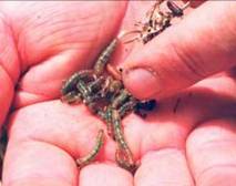
Tropical grass webworm
There is usually a seasonal trend in topical grass webworms, with population growth being related to climatic conditions. Moths emerge at the end of January, with a small peak in larval numbers in February, followed by another significant emergence of moths in early to mid March, as shown in figure 10 (below) and concurrent larval feeding damage throughout March and April.
Since the initial outbreak in 1999, damage from populations of larval TGW has never been as widespread. However, severe feeding damage to kikuyu pasture by TGW as high as that recorded in 1999 has occurred in localised areas in autumn of 2000, 2001, 2002 and 2007.
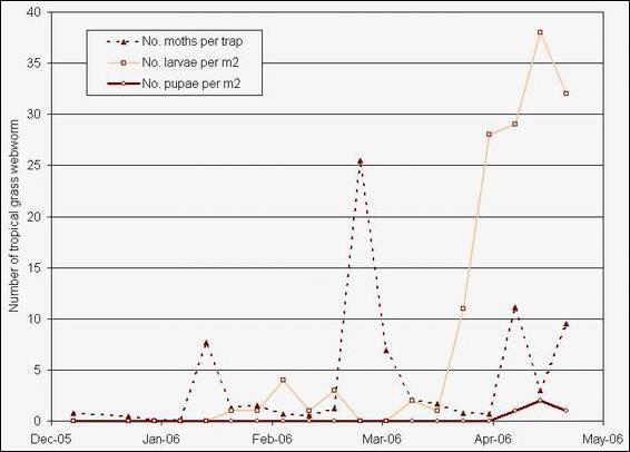
Figure 10: Number of tropical grass webworm larvae, pupae and moths recorded on Aupouri Peninsula from December 2005 to May 2006 (Dymock 2007).
The years in which significant damage did not occur were characterised by either cooler temperatures and/or significant spells of dry weather at crucial stages in the TGW life cycle, particularly in February and March. In addition to these climatic factors influencing TGW build-up each year, the continued presence of parasitoids attacking TGW larvae and pupae (Meteorus pulchricornis, Lissopimpla excelsa, Pales sp.) may now be exerting increased control of TGW.
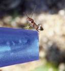
Argentine ants
Argentine ants (Linepithema humile) are widespread throughout Northland. In March 2007 Argentine ant free areas included much of the Far North and all Crown administered offshore islands. Up to March 2007 there were no reports of Argentine ant populations spreading into the larger Crown administered forests such as Waipoua and Puketi-Omahuta Forests, although populations of the species are present on the margins of some forests.
There are Argentine ant populations in urban areas throughout the rest of the region, particularly on the east and west coasts. Where coordinated control is undertaken by community groups successful reduction in Argentine ant populations can be achieved.
Indigenous vegetation cover
In 2002 approximately 416,900 hectares (33%) of Northland's land area was covered in indigenous vegetation (LCDB2). There was a slight decrease in the land area covered in indigenous vegetation from 1997 to 2002, which was approximately 419,100 ha in 1997. This is mostly through a decrease in the following native land covers: broadleaved indigenous hardwoods, indigenous forest and manuka/kanuka. However since 2002 it is possible that this trend has stabilised or turned with the significant amounts of protection and enhancement of indigenous biodiversity that is being carried out in Northland.
Of the 416,900 ha of indigenous vegetation land cover in Northland in 2002, approximately 36% of it was legally protected in 2006 as either Department of Conservation reserves, QEII covenants, WDC covenants, wildlife refuge or District Council reserves, where the land has been set aside as a reserve for the protection of flora, fauna or wildlife reasons. The native land cover protected in Northland in 2006 was predominately indigenous forest and manuka/kanuka.
For more information on the extent and protection of indigenous vegetation in Northland refer to the Indigenous Biodiversity chapter.