New bridge underway as part of Otiria-Moerewa floodworks
21 Mar 2023, 8:30 AM
A start has been made on a new 60-metre long, $3.5 million road bridge at the heart of new works to better protect Otiria and Moerewa from the impacts of flooding.
Construction of Otiria’s Pokapu Rd bridge – underway on multiply-owned whanau land with the blessing of its shareholders – began in January after a dawn blessing ceremony late last year.
Newly-elected Northland Regional Council member Geoff Crawford (chair of the Taumarere Flood Mitigation Working Group) says the project is unusual in that unlike most flood mitigation projects it is not trying to ‘tame’ nature.
“This one is actually restoring the Otiria Stream to its natural flow in accordance with new national freshwater ‘Te Mana o te Wai’ principles.”
The natural flow had been blocked decades ago with the construction of Ngapipito and Pokapu Roads and Otiria’s railroad embankment.
Councillor Crawford says the area is also unusual in that in a 1-in-100-year flood 70 percent of the flow from the Otiria Stream and 80% from the Waiharakeke River would travel across the associated flood plain.
“In most rivers this would be reversed, with roughly 80% of floodwaters contained within a riverbank and only 20% on a flood plain.”
The anomaly is largely because both Otiria and Waiharakeke are perched atop thousands of years old lava flows which have been too hard for the streams to carve deep channels into.
“However, the Waiharakeke River falls off the lava flow at Pokapu Rd into a series of waterfalls and over the years has carved out a massive canyon increasing the cross-sectional area from just 36 square metres at Pokapu Rd to more than 600 square metres at Otiria Marae.”
Councillor Crawford says it was the community that had several years ago come up with the idea of returning the water to its natural flow (as it was before any built infrastructure) and into an area historically much better able to cope with the large volumes of water which floods involved.
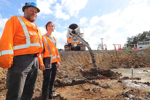
GHK Piling foreman Darryl Nisbet and Northland Regional Council Rivers Project Manager Meg Tyler at the site of the new bridge. They’re pictured as site concrete fill is being poured into pile holes to contain loose rock. The area will eventually be drilled through and piled for a pier that will form the middle support sections for the bridge.
When the project is finished, water will once again flow into the places it had for thousands of years before human influences.
To achieve this the Northland Regional Council has been working on a staged plan with the local community, the Taumarere Flood Mitigation Working Group, local marae, Ngati Kopaki and Ngati Te Ara kaumatua, kuia and kaitiaki, the Far North District Council and Kānoa - Regional Economic Development & Investment Unit.
Stage I of the project – construction of the downstream section of new $1.4 million 80-metre-long spillway at Otiria – was completed last year. (Flood infrastructure is completed from downstream to upstream.)
The recently started Stage II – currently due for completion before Christmas this year – will see the replacement of an existing 18-metre-long road bridge with the new 60-metre structure, and effectively triple the flow of floodwaters that can pass beneath it.
“In previous floods this water would typically be diverted – in part by the existing bridge structure and railroad – downstream to land at Otiria and Moerewa.”
A final and third stage will be completed at the same time as work on the bridge and will see excavation of the remaining 800-metres of spillway and the removal of the existing Pokapu Rd road bridge.
The works cumulatively mean that in a flood, most water would be sent down the new spillway and into the Waiharakeke River past the lava flow, where the river is considerably wider and deeper.
Engineers’ calculations show that while floods would still occur, parts of the area currently subjected to potentially damaging and life-threatening half-metre deep floodwaters should see that reduced to just ankle height instead.
Northland Regional Councillor Marty Robinson late last year attended the dawn blessing for Stage II in lieu of Cr Crawford (because of COVID contact) and paid tribute to the whanau who had agreed to allow the new bridge to be built on their land.
The $7M total cost of the project is being funded 57 percent by Kanoa with another 28% met through targeted local and regionwide Northland Regional Council River rates. In recent months the project had secured a final 13% ($1M) from the Far North District Council’s Better Off Fund.
The new single-lane bridge and an associated footpath is being built by contractors Ventia.
As part of the council’s procurement requirements Ventia has hired two recently graduated students from Bay of Islands College and one local rangatahi (young person) for training, upskilling and long-term employment.
The project has also seen two kaitiaki employed as cultural monitors during the construction.
“This was considered essential due to the rich Māori history and high number of sites of significance in the area.”
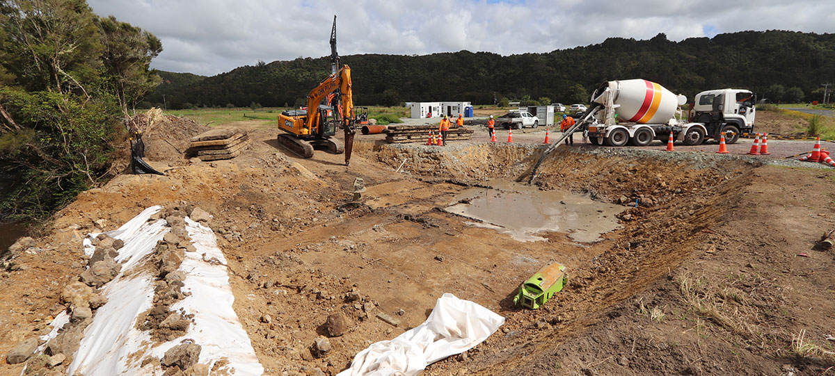
Workers pour site concrete fill into pile holes to contain loose rock. The area will eventually be drilled through and piled for a pier that will form the middle support sections for the new bridge.