Keeping stock out of waterways
Livestock activity can damage the bed and banks of our waterways. Dung, urine and sediment can also seriously impact water quality, the lives of animals living there and mahinga kai values.
Rules in the Resource Management (Stock Exclusion) Regulations 2020 and the Regional Plan for Northland mean that stock must be kept out of waterways (also called ‘stock exclusion’).
The rules apply to beef cattle, dairy cows, dairy support cows, pigs, deer and sheep and are different for each.
Rules for keeping stock out of waterways
The section below summarises the rules for keeping stock out of waterways:
If you have any questions about the rules and how they relate to what you do on your property get in touch with us and we’ll help sort it out.
Important things to note about the summary:
- There are specific requirements that are not shown in the summary – please refer to the relevant rules for details.
- Both sets of rules must be complied with.
- The summary doesn’t include ‘Wetlands identified in a regional plan’ (as set out in the Stock Exclusion Regulations) because there currently aren’t any.
- “(0m)” and “(3m)” refers to the minimum distance that stock must be excluded from the water body.
- The setback can be less than 3 metres under the Stock Exclusion Regulations if there was a permanent fence in place on 3 September 2020 (scroll down for the definition of ‘permanent fence’).
- The width of a river, stream or artificial watercourse is measured when it is at its annual fullest flow without overtopping its banks.
- In some cases where the rules are very similar, only the most stringent or earliest applying rule is shown.
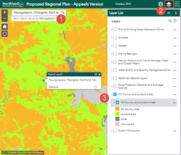
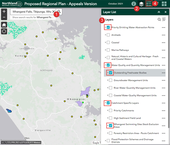
Using the maps
These are the maps the rules for keeping stock out of waterways refer to:
Hill country areas and Lowland areas (#Regional Plan)
Open the Proposed Regional Plan map viewer
Other mapped areas
Open the Proposed Regional Plan map viewer
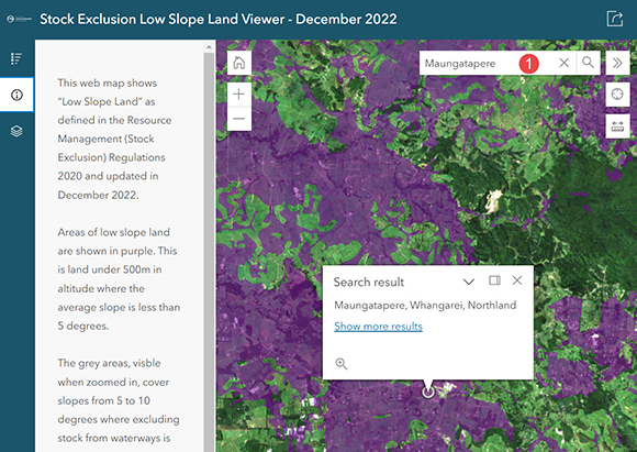
Low slope land (*Stock Exclusion Regulations)
Open the Low slope land viewer
Dairy - rules
| Key | |
|
# Regional Plan rule C.8.1.2 |
| Waterbody to be fenced | By when and setback from water |
| Wetlands >0.05ha | 1 January 2023 (0m)# |
| Wetlands that support a population of threatened species - There are no maps. See below for more details about threatened species | 1 July 2025 (0m)* |
| Lakes (all) | 1 July 2023 (3m)* |
| Lakes >1ha | June 2022 (0m)# |
| Rivers upstream of swimming sites on Hātea and Raumanga rivers - Identified in the Regional Plan Maps click on ‘Catchment Specific layers’ | June 2024 (0m)# |
| Rivers and streams > 1m - Wider than one metre at any point within a property |
Feb 2022 (0m)# 1 July 2023 (3m)* |
| Streams < 1m - The entire stream within a property is less than one metre wide. Only applies to streams that continually contain water | 1 January 2023 (0m)# |
| Artificial watercourse >1m - A man-made channel, continually flowing with water. It does not include a channel constructed in or along the path of any historical or existing river, stream or natural wetland – refer Regional Plan for full definition | Feb 2022 (0m)# |
| Artificial watercourse <1m - A man-made channel, continually flowing with water. It does not include a channel constructed in or along the path of any historical or existing river, stream or natural wetland – refer Regional Plan for full definition | 1 January 2023 (0m)# |
| Inanga spawning sites - The margins of rivers and estuaries that are inundated by spring high tides. There is no map of inanga spawning sites | June 2022 (0m)# |
| 1,000m upstream of a mapped priority drinking water abstraction point - Refer Regional Plan Maps – click on ‘Priority Drinking Water Abstraction Points’ | June 2022 (0m)# |
| Outstanding freshwater body - Identified in the Regional Plan Maps click on ‘Water Quality and Quantity Management Units’ then ‘Outstanding Freshwater Bodies’ | June 2022 (0m)# |
| Coastal marine area - Beaches, mudflats, saltmarsh and other foreshore areas. This rule has been in place since 2009 (previously in the Regional Coastal Plan for Northland) | 2009 (0m)# |
Pigs - rules
| Key | |
|
# Regional Plan rule C.8.1.2 |
| Waterbody to be fenced | By when and setback from water |
| Wetlands >0.05ha | 1 January 2023 (0m)# |
| Wetlands that support a population of threatened species - There are no maps. See below for more details about threatened species | 1 July 2025 (0m)* |
| Lakes (all) | 1 July 2023 (3m)* |
| Lakes >1ha | June 2022 (0m)# |
| Rivers upstream of swimming sites on Hātea and Raumanga rivers - Identified in the Regional Plan Maps click on ‘Catchment Specific layers’ | June 2024 (0m)# |
| Rivers and streams > 1m - Wider than one metre at any point within a property |
Feb 2022 (0m)# 1 July 2023 (3m)* |
| Streams < 1m - The entire stream within a property is less than one metre wide. Only applies to streams that continually contain water | 1 January 2023 (0m)# |
| Artificial watercourse >1m - A man-made channel, continually flowing with water. It does not include a channel constructed in or along the path of any historical or existing river, stream or natural wetland – refer Regional Plan for full definition | Feb 2022 (0m)# |
| Artificial watercourse <1m - A man-made channel, continually flowing with water. It does not include a channel constructed in or along the path of any historical or existing river, stream or natural wetland – refer Regional Plan for full definition | 1 January 2023 (0m)# |
| Inanga spawning sites - The margins of rivers and estuaries that are inundated by spring high tides. There is no map of inanga spawning sites. | June 2022 (0m)# |
| 1,000m upstream of a mapped priority drinking water abstraction point - Refer Regional Plan Maps – click on ‘Priority Drinking Water Abstraction Points’ | June 2022 (0m)# |
| Outstanding freshwater body - Identified in the Regional Plan Maps click on ‘Water Quality and Quantity Management Units’ then ‘Outstanding Freshwater Bodies’ | June 2022 (0m)# |
| Coastal marine area - Beaches, mudflats, saltmarsh and other foreshore areas. This rule has been in place since 2009 (previously in the Regional Coastal Plan for Northland) | 2009 (0m)# |
Beef - rules
| Key | |
|
# Regional Plan rule C.8.1.2 |
| Waterbody to be fenced | By when and setback from water |
| Wetlands >0.05ha |
1 January 2025 (0m) - Lowland areas# |
| Wetlands that support a population of threatened species - There are no maps. See below for more details about threatened species | 1 July 2025 (0m)* |
| Lakes >1ha | June 2022 (0m)# |
| Rivers upstream of swimming sites on Hātea and Raumanga rivers - Identified in the Regional Plan Maps click on ‘Catchment Specific layers’ | June 2024 (0m)# |
| Rivers and streams > 1m - Wider than one metre at any point within a property |
Intensively grazed1 only - 1 July 2023 (3m)* 1 January 2025 (0m) - Lowland areas# 1 January 2025 (0m) - Hill country areas in the Mangere catchment# |
| Streams < 1m - The entire stream within a property is less than one metre wide. Only applies to streams that continually contain water |
1 January 2030 (0m) - Lowland areas# 1 January 2030 (0m) - Hill country areas in the Mangere catchment# |
| Artificial watercourse >1m - A man-made channel, continually flowing with water. It does not include a channel constructed in or along the path of any historical or existing river, stream or natural wetland – refer Regional Plan for full definition |
1 January 2025 (0m) - Lowland areas# 1 January 2025 (0m) - Hill country areas in the Mangere catchment# |
| Artificial watercourse <1m - A man-made channel, continually flowing with water. It does not include a channel constructed in or along the path of any historical or existing river, stream or natural wetland – refer Regional Plan for full definition |
1 January 2030 (0m) - Lowland areas# 1 January 2030 (0m) - Hill country areas in the Mangere catchment# |
| Inanga spawning sites - The margins of rivers and estuaries that are inundated by spring high tides. There is no map of inanga spawning sites. | June 2022 (0m)# |
| 1,000m upstream of a mapped priority drinking water abstraction point - Refer Regional Plan Maps – click on ‘Priority Drinking Water Abstraction Points’ | June 2022 (0m)# |
| Outstanding freshwater body - Identified in the Regional Plan Maps click on ‘Water Quality and Quantity Management Units’ then ‘Outstanding Freshwater Bodies’ | June 2022 (0m)# |
| Coastal marine area - Beaches, mudflats, saltmarsh and other foreshore areas. This rule has been in place since 2009 (previously in the Regional Coastal Plan for Northland) | 2009 (0m)# |
Dairy support - rules
| Key | |
|
# Regional Plan rule C.8.1.2 |
| Waterbody to be fenced | By when and setback from water |
| Wetlands >0.05ha | 1 January 2025 (0m) - Lowland areas# |
| Wetlands that support a population of threatened species - There are no maps. See below for more details about threatened species | 1 July 2025 (0m)* |
| Lakes (all) | 1 July 2025 (3m)* |
| Lakes >1ha | June 2022 (0m)# |
| Rivers upstream of swimming sites on Hātea and Raumanga rivers - Identified in the Regional Plan Maps click on ‘Catchment Specific layers’ | June 2024 (0m)# |
| Rivers and streams > 1m - Wider than one metre at any point within a property |
1 July 2025 (3m)* 1 January 2025 (0m) - Hill country areas in the Mangere catchment# |
| Streams < 1m - The entire stream within a property is less than one metre wide. Only applies to streams that continually contain water |
1 January 2030 (0m) - Lowland areas# 1 January 2030 (0m) - Hill country areas in the Mangere catchment# |
| Artificial watercourse >1m - A man-made channel, continually flowing with water. It does not include a channel constructed in or along the path of any historical or existing river, stream or natural wetland – refer Regional Plan for full definition |
1 January 2025 (0m) - Lowland areas# 1 January 2025 (0m) - Hill country areas in the Mangere catchment# |
| Artificial watercourse <1m - A man-made channel, continually flowing with water. It does not include a channel constructed in or along the path of any historical or existing river, stream or natural wetland – refer Regional Plan for full definition |
1 January 2030 (0m) - Lowland areas# 1 January 2030 (0m) - Hill country areas in the Mangere catchment# |
| Inanga spawning sites - The margins of rivers and estuaries that are inundated by spring high tides. There is no map of inanga spawning sites. | June 2022 (0m)# |
| 1,000m upstream of a mapped priority drinking water abstraction point - Refer Regional Plan Maps – click on ‘Priority Drinking Water Abstraction Points’ | June 2022 (0m)# |
| Outstanding freshwater body - Identified in the Regional Plan Maps click on ‘Water Quality and Quantity Management Units’ then ‘Outstanding Freshwater Bodies’ | June 2022 (0m)# |
| Coastal marine area - Beaches, mudflats, saltmarsh and other foreshore areas. This rule has been in place since 2009 (previously in the Regional Coastal Plan for Northland) | 2009 (0m)# |
Deer - rules
| Key | |
|
# Regional Plan rule C.8.1.2 |
| Waterbody to be fenced | By when and setback from water |
| Wetlands >0.05ha | 1 January 2025 (0m) - Lowland areas# |
| Wetlands that support a population of threatened species - There are no maps. See below for more details about threatened species | 1 July 2025 (0m)* |
| Lakes >1ha | June 2022 (0m)# |
| Rivers upstream of swimming sites on Hātea and Raumanga rivers - Identified in the Regional Plan Maps click on ‘Catchment Specific layers’ | June 2024 (0m)# |
| Rivers and streams > 1m - Wider than one metre at any point within a property |
1 January 2025 (0m) - Lowland areas# 1 January 2025 (0m) - Hill country areas in the Mangere catchment# |
| Streams < 1m - The entire stream within a property is less than one metre wide. Only applies to streams that continually contain water |
1 January 2030 (0m) - Lowland areas# 1 January 2030 (0m) - Hill country areas in the Mangere catchment# |
| Artificial watercourse >1m - A man-made channel, continually flowing with water. It does not include a channel constructed in or along the path of any historical or existing river, stream or natural wetland – refer Regional Plan for full definition |
1 January 2025 (0m) - Lowland areas# 1 January 2025 (0m) - Hill country areas in the Mangere catchment# |
| Artificial watercourse <1m - A man-made channel, continually flowing with water. It does not include a channel constructed in or along the path of any historical or existing river, stream or natural wetland – refer Regional Plan for full definition |
1 January 2030 (0m) - Lowland areas# 1 January 2030 (0m) - Hill country areas in the Mangere catchment# |
| Inanga spawning sites - The margins of rivers and estuaries that are inundated by spring high tides. There is no map of inanga spawning sites. | June 2022 (0m)# |
| 1,000m upstream of a mapped priority drinking water abstraction point - Refer Regional Plan Maps – click on ‘Priority Drinking Water Abstraction Points’ | June 2022 (0m)# |
| Outstanding freshwater body - Identified in the Regional Plan Maps click on ‘Water Quality and Quantity Management Units’ then ‘Outstanding Freshwater Bodies’ | June 2022 (0m)# |
| Coastal marine area - Beaches, mudflats, saltmarsh and other foreshore areas. This rule has been in place since 2009 (previously in the Regional Coastal Plan for Northland) | 2009 (0m)# |
Sheep- rules
| Key | |
|
# Regional Plan rule C.8.1.2 |
| Waterbody to be fenced | By when and setback from water |
| Inanga spawning sites - The margins of rivers and estuaries that are inundated by spring high tides. There is no map of inanga spawning sites. | June 2022 (0m)# |
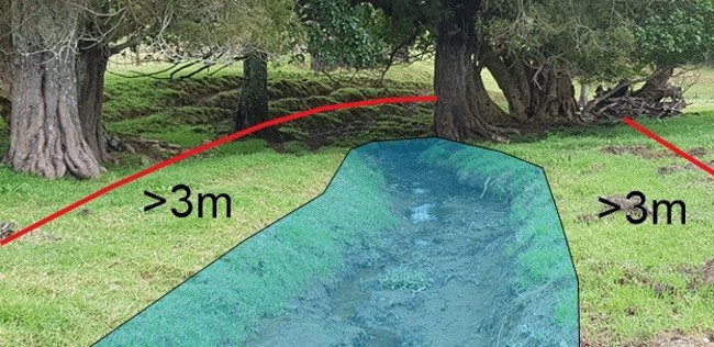
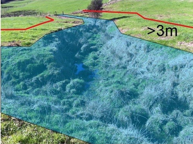
3M buffers for stock exclusion
The photos below illustrate how the three-metre buffer strip is measured.
Stock crossings
When stock are required to be kept out of a waterway, they may still cross streams, rivers and lakes provided:
- they are supervised and actively driven across the waterbody
- the stock don’t cross the same stream, river or lake more than twice in any month
- the entry and exit points are not more than five metres wide
Where stock will be crossing a stream, river or lake more than twice in any month, a dedicated bridge or culvert must be installed. Check the rules as there are requirements for installing bridges and culverts or you may need a resource consent.
Permanent fence
A permanent fence is defined as a post and batten fence with driven or dug fence posts, an electric fence with at least two electrified wires and driven or dug fence posts, or a deer fence.
Threatened species
Threatened species means any indigenous species of flora or fauna that rely on water bodies for at least part of its life cycle and meets the criteria for nationally critical, nationally endangered, or nationally vulnerable species in the New Zealand Threat Classification System Manual.
What is a wetland?
It can be difficult to distinguish a wetland from a wet paddock. Find out more about wetlands and how to determine them.
More information
Guidance on the livestock exclusion regulations is available on the Ministry for the Environment website.