Fish passage and īnanga spawning
Fish passage
New Zealand has more than 50 species of native freshwater and sports fish. It’s important that instream structures such as culverts and weirs are designed to allow for fish passage, so that fish can move upstream and downstream to complete their lifecycle.
All our native fish species can swim, but only nine can climb past some obstacles. This climbing ability varies and is limited to the juvenile stage in most cases. Only kōaro and eels can climb as adults. The requirement to provide for fish passage applies to all species present at all life stages.
If you have structures on your property that restrict or prevent fish passage that cannot be removed, there are things you can do fix them.
How to fix fish passage barriers at existing instream structures
Summary
There are rules and regulations for managing fish passage in Northland. These include:
- National regulations – National Environmental Standards for Freshwater (NES-F)
- Regional rules – Northland Regional Plan
- Freshwater Fisheries Regulations – the Department of Conservation (DOC) has responsibilities to manage fish passage in any natural New Zealand waterway. This means culverts and fords may not impede fish passage unless they have been approved or exempted by DOC. See more at doc.govt.nz
National and Regional Regulations
The Resource Management (National Environmental Standards for Freshwater) Regulations 2020 (NES-F) introduced new national regulations for fish passage to be considered alongside regional rules in the Regional Plan.
Under the NES-F, all temporary and permanent instream structures installed from 3 September 2020 must allow fish to pass as easily as if the structure was not present. If the structure could be difficult for fish to pass, a resource consent may be required. While the new regulations do not apply to instream structures installed before 3 September 2020, it is still important to ensure fish can get past.
How to fix fish passage barriers at existing instream structures
Installing a structure with the sole purpose to aid fish passage is a permitted activity in Section C2.1.6 of the Northland Regional Plan if certain conditions are met.
The NES-F regulations for permitted instream activities are detailed below. There are two main requirements:
- Under permitted activity rules, new structures must be designed, installed and maintained in a way that will provide for the same passage of fish upstream and downstream as would exist without the structure.
Specific design criteria for weirs and culverts must be followed. - You will need to provide information about the new structure to us within 20 days of installation in accordance with NES-F Regulation 62 (See ‘Reporting back to us’ for details).
Under national and regional rules, the extension, maintenance and removal of existing structures is a permitted activity (with conditions).
Rules for culverts
The following national and regional rules apply if you are carrying out works to install or maintain a temporary or permanent culvert:
- Permitted activity conditions for culverts (NES-F Regulation 70). There are also requirements to provide information to the Northland regional Council (NES-F Regulation 62 & 63)
- Rule C.2.1.8 Construction and installation of structures – permitted activity (Regional Plan)
If you cannot meet all the requirements of both rules, you will have to apply for resource consent.
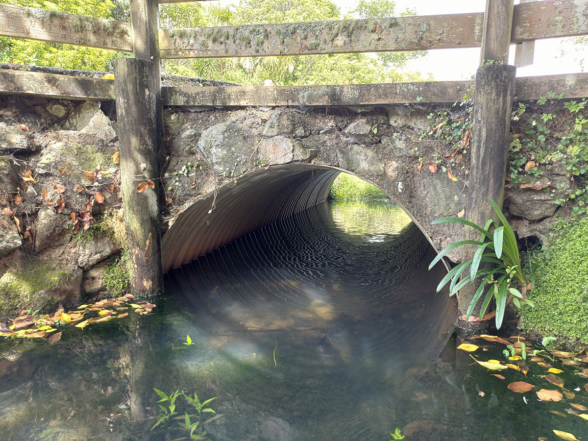
A well-designed culvert allows fish to move through as part of their lifecycle, and reduces stream-bed scouring.
Rules for weirs
The following national and regional rules apply if you are carrying out works to install or maintain a temporary or permanent weir:
- Permitted activity conditions for weirs (NES-F Regulation 72). There are also requirements to provide information to the Northland regional Council (NES-F Regulation 62 and 64).
- Rule C.3.1.2 Small dam – permitted activity (Regional Plan)
If you cannot meet all the requirements of both rules, you will have to apply for resource consent.
Rules for flap gates
A resource consent is always required for a passive flap gate (NES-F Regulation 74).
- flap gate means a hinged gate that controls fluctuations in tidal or flood water, such as a tide gate or flood gate
- a passive flap gate is flap gate which is not automated and whose opening or closing is caused by a positive head differential on the upstream or downstream side.
Rules for fords
The following national and regional rules apply if you are carrying out works to install or maintain a temporary or permanent ford:
- There are no NES-F rules for fords, but there requirements to provide information to the regional council (NES-F Regulation 62 and 67)
- Rule C.2.1.8 Construction and installation of structures – permitted activity (Regional Plan).
If you cannot meet the requirements of the rule you will have to apply for resource consent.
Rules for dams
The following national and regional rules apply if you are carrying out works to install or maintain a temporary or permanent dam:
- There are no NES-F rules for dams, but there requirements to provide information to the regional council (NES-F Regulation 62 and 66)
- Rule C.3.1.2 Small dam – permitted activity (Regional Plan).
If you cannot meet the requirements of the rule you will have to apply for resource consent.
Culverts, weirs, flap gates, fords and dams installed after 3 September 2020 must meet minimum reporting requirements such as height, width and location under the NES-F.
When installing a structure in a waterway, you must provide information about the structure to us within 20 days of it being installed. Information must be provided for both permitted and consented activities.
Examples of the information commonly required include:
- the type of structure
- physical characteristics of the structure
- physical characteristics of the stream the structure has been installed within, such as the flow
- the likelihood of the structure to prevent fish passage
- visual evidence both upstream and downstream of the structure.
See the links provided under the rules for each type of structure for the specific information requirements.
To collect the information required you will need:
- a measuring tape
- a small item that floats
- a device with a timer such as a stopwatch or phone for calculating the water velocity
- a device that can take photos such as a camera or phone.
This information can be provided to council by:
- Completing an assessment using Fish Passage Assessment Tool (FPAT) in the NIWA Citizen Science app, or
- Complete the Instream Structure Form.
We have expert staff to provide localised assistance and advice regarding land management, consents and compliance.
If you think you may require a resource consent, please contact us. We can arrange for you to have a free pre-application meeting. For support in your local area, we can arrange for your local land management, biodiversity, or fish passage advisor to pop out for a chat, or to catch up with you online or via email to help sort things out.
Īnanga spawning
Īnanga are the smallest whitebait species and their populations are declining.
The part of waterways where tidal flows meet freshwater is a key habitat for inanga spawning. Spawning occurs in areas where high spring tides can reach, but the water isn’t too salty. During spring tides īnanga can lay their eggs in vegetation high up the riverbanks, above the normal river flow height.
The Regional Plan has restrictions on land use activities around īnanga spawning sites. The following activities may not be permitted and may require a consent:
- Stock access (C.8.1.2)
- Land preparation (C.8.2.1)
- Earthworks (C.8.3.1)
- Drainage and flood controls from 1 March to 30 September (C.4.1.9)
- Restoration of natural flows (C.3.1.6)
Northland Regional Council has created an īnanga spawning map to indicate where these areas are likely to be. You can use the map to help identify whether you may have īnanga spawning sites on your land.
For more information about īnanga spawning and how you can help to protect īnanga if you think you may have a spawning site on your property, download our information sheet: Where are our īnanga? (PDF 1.39 MB)