Land use and soil quality
Our land
Northland has a variety of landforms, soil types and associated land uses. Its landforms range from young active sand dunes along the coasts to relatively old greywacke, and volcanic peaks and hills in inland areas. One of the notable features of the region is that it has few high mountain ranges with no part being more than 800 metres above sea level. It also has few large areas of flat, low-lying land, the most significant lowlands being adjacent to the Awanui and Northern Wairoa rivers.
The soils in the region vary considerably, reflecting the very complex geology, in structure and origin, ranging from those which are poorly drained and relatively infertile (for example, gumland soils), to those which are free draining and fertile, primarily of alluvial or volcanic origin.
Over 230 different soil types have been identified and they are generally shown on the NZ Land Inventory NZMS 290 Map series. Some of this land was formerly covered in forest and large-scale deforestation exposed the soil to erosion with off-site effects of flooding, siltation, lowered water quality, and altered high and low flow regimes in rivers and streams. In Northland farming, forestry and horticulture collectively contribute 13.7% of the Gross Domestic Product (GDP) of the region. The future of these industries depends on maintaining the productive capacity of Northland's soils.
The consequence of poor soil management is not only the loss of productivity but also an increased environmental impact including the downstream degradation of water quality. Previous State of the Environment reports identified sediment as a major contaminant of Northland's rivers.
Under the Resource Management Act, both the regional council and district councils have land management responsibilities. The regional council's responsibilities are fairly specific, relating primarily to soil conservation, mitigation of natural hazards, and control of contaminant discharges and associated water quality management. However, it also has a general overview role in terms of identifying and setting policy in relation to any effects of the use, development or protection of lands which are of regional significance.
The regional council also has a specific function as a catchment board under the Soil Conservation and Rivers Control Act 1941 to minimise and prevent damage within its boundaries by floods and erosion, including doing works to lessen erosion or the likelihood of erosion, and promoting soil conservation.
The district councils have the major responsibilities for controlling the subdivision of land and associated land use activities in terms of their location, servicing, effects on natural features and other amenities.
What do we want for our land and soil?
The operative Regional Policy Statement for Northland details existing council and community objectives for each natural and physical resource in the region. The objectives relating to soil conservation and land management are:
• The maintenance, and where possible, enhancement of the life-supporting capacity of soils, especially those which have potential to support intensive primary production.
• The protection of the soil resources, including soil quality and soil quantity, from degradation or loss as a result of unsustainable land uses and land use practices.
• The safeguarding of the life-supporting capacity of water and ecosystems from the adverse effects of unsustainable land uses and land use practices.
The following are the anticipated environmental achievements after the implementation of the policies for soil conservation and land management in the Regional Policy Statement for Northland:
• Continued availability of highly versatile soils for primary production.
• More widespread adoption of soil conservation practices within land use and subdivision proposals.
• Reduction of erosion in high-risk areas.
• Reduction in the volumes of soil and other contaminants entering surface water bodies.
Note: the operative Regional Policy Statement is currently being reviewed. The proposed Regional Policy Statement (2013) is available at www.nrc.govt.nz/rps
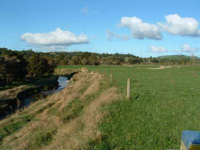
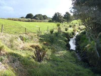 A stream on a dairy farm that has been fenced and planted to protect the waterway.
What is our land use?
Northland's land resource
Information on soil types along with other related physical factors such as underlying geology, slope and drainage, have been used as a basis for classifying the land nationally and within the region. The NZ Land Resources Inventory Worksheets identify eight broad land classes, along with a number of more detailed sub-classes and units. Class 1 land is considered the most versatile and productive in terms of conventional agriculture, horticulture and forestry, whilst Class 8 land has such limitations that it is considered incapable of productive use.
The Worksheets (summarised in Table 5) show that the region has only 400 hectares of Class 1 land and 36,000 hectares of Class 2 land, which together make up about 3% of the total land area. Most of this potentially highly productive land is either volcanic or alluvial in origin and located in the Kerikeri, Whāngārei and Dargaville areas. Some of the freer-draining and/or flood-free Class 3 land, again soils derived from volcanic material, alluvium, sand and peat, is also capable of intensive horticulture and agriculture so has been identified as highly versatile soils on plans available on the websites of the Northland Regional Council and each of the district councils.
* Amendments to the Land Use Capability classification, introduced with the 3rd Edition, Land Use Capability Handbook in 2010, extend the range of limitations that may apply to Class 5 land. A proportion of land currently assessed as 6e on the Worksheets can be reassessed as Class 5e under the amendments.
Figure 37: Northland's land cover (Source: Derived from Land Cover Database 3 data)
| Land use capability |
% of land area | Limitations (increasing limitations from Classes 1 to 8) |
Soil types |
Land use activities |
Locations |
| 1 | 0.03 | Nil | Volcanic loams |
All types | Maunu Ōhaeawai |
| 2 | 2.86 | Soil moisture (Seasonally too dry or too wet) |
Recent volcanic/peat /alluvial |
Horticulture/ cropping/pastoral farming |
Kerikeri/Maunu/ Maungatapere Glenbervie/ Ruāwai |
| 3 | 7.19 | Soil moisture/ rocks/drainage /flooding |
Alluvial/ volcanic/peat/ clay |
Pastoral farming/ horticulture/ cropping |
Whāngārei /Kerikeri/ river margins/ Hikurangi Swamp/Awanui Flats |
| 4 | 23.85 | Drainage/ erosion/rocks/ soil pans |
Sedimentary/ alluvial/ volcanic/peat/ clays |
Dairying/ sheep/beef/ forestry |
Throughout Northland |
| 5* | 0.66 | Stony/dry or too wet for cultivation |
Limestone/ volcanic/ alluvium |
Pastoral farming/forestry | Small scattered areas throughout Northland |
| 6 | 48.57 | Erosion/steep/ flooding/rocky/dry |
Sedimentary/ old volcanic/ greywacke/sand, etc. |
Sheep/beef/ forestry |
"Waiotira"-type hill country throughout Northland |
| 7 | 12.14 | Erosion/steep/ flooding/stony/ wetness |
Greywacke/ Sedimentary/ old volcanic/ sand |
Sheep/ forestry/ land/ protection-production forest |
East Coast hill country, for example, Mt Tiger, gumland and steep, old volcanic, sands |
| 8 | 2.52 | Erosion/steepness/ wetness |
Greywacke/ old volcanic/ sand foredunes |
Total incapable of productive use |
Cliffs, gorges, very steep land and sand foredunes throughout Northland |
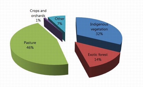
Like much of New Zealand, agriculture, forestry and horticulture play an important part in the local economy. This is reflected in the percentage of land used for these activities with just under half the land in pasture (46%), and 14% in exotic forest. A small proportion of land is in horticulture (1%) and around a third (32%) indigenous forest (Figure 37).
Figure 37: Northland's land cover (Source: Derived from Land Cover Database 3 data)
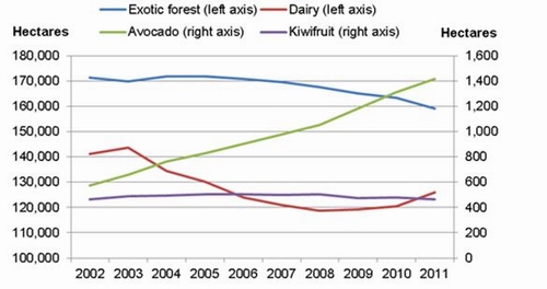
Based on 2002 and 2007 census data, 2011 sampling, and the recently released Land Cover Database 3, the area in:
• Exotic forest has steadily decreased from 171,000ha to 159,000ha (7%);
• Dairy farming from 141,000ha to 119,000ha in 2008 and back up to 126,000 (10%);
• Avocado orchards occupied 575ha in 2002 and now 1415ha, a 146% increase;
• Kiwifruit increased from 465ha to 505ha in 2005 and back to 464ha in 2011.
Figure 38: Changes in land use (Sources: MAF, Exotic Forest Description; Dairy NZ and LIC, New Zealand Dairy Statistics, various years; New Zealand Avocado Growers' Association Annual Report, various years; Zespri Annual reports, various years)
Pastoral farming
Approximately half of the region's land is used for pastoral farming, with about 385,000 dairy cattle (275,000 cows), 402,000 beef cattle and 400,000 sheep in Northland, in 2011. Within the five-year term of this report, these figures represent a 3.5% increase in dairy cow numbers from 2006 to 2011 but a decrease in total dairy cattle, most probably as a result of the 2009/10 drought. Beef cattle numbers have dropped by 18% over that same period and sheep numbers by 24%.
Dairy
While some dairy farmers are intensifying their production, the regional average lags behind most of the rest of New Zealand in terms of herd size, production per cow and production per hectare. Between 2006 and 2011, the number of herds decreased by 4.5%, the number of cows in milk increased by 3.5%, while effective grazing area and average herd size increased by 4.3% and 8.8%. The total number of dairy stock increased by only 1.8% with the 2011 figure being 3.8% down on the 2008 total, perhaps as a result of the 2009-2010 drought.
On average, 8.8% larger dairy herds are being carried on fewer but larger dairy farms with the average effective grazing area increasing by 9.7%. The number of cows per effective hectare is around 2.18 but varies from season to season. The issue of significance to soil condition is that larger herds and more cows are being milked through the winter. At some times of the year, late spring and early summer, bigger mobs will be concentrated on smaller areas while paddocks are taken out of the grazing rotation for silage. The area available for grazing will be reduced further when crops are grown on the farm. The concentration of livestock, particularly on wet pasture, can create pugging and compaction issues which degrade soil condition and exacerbate runoff.
Table 6: Dairy stock numbers in Northland (Livestock Improvement Corporation/Dairy NZ – 2006/07 to 2010/11)
4.5% reduction in number of dairy farms [976 to 930] |
| 3.5% increase in number of cows, [265,776 to 275,070] |
| 1.8% increase in total dairy stock [378,152 to 385,000] |
| but dropped from pre-drought figures of 3.8% increase [392,577 in 2009] |
| 4.3% increase in overall effective dairy grazing area [120,926 to 126,081] |
| 8.8% increase in herd size and [272 to 296] |
| 9.7% increase in effective grazing area per farm [124 to 136] |
| Cows/hectare reduced slightly (1.8%) to 2.18 but varies from season to season. |
Source: Statistics NZ
Figure 39: Development in Northland dairy, 2002-11
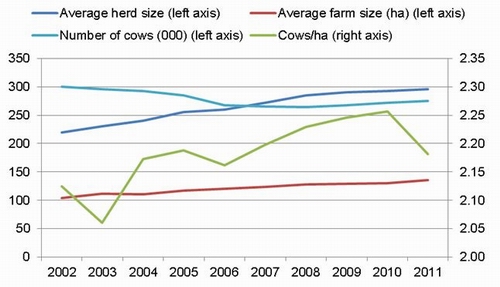
Source: Dairy NZ and LIC, New Zealand Dairy Statistics, various years
Beef
In 2006 there were 469,262 beef cattle in Northland and in 2010 there was a slight decline to 465,169 (-0.9%). This is insignificant as numbers have ranged between 609,552 and 451,849 since 1990, that is, approximately 15% either side of the median. The 2010 low can be attributed almost entirely to the 2009/10 drought. A proportion of beef farmers are also intensively grazing bulls, using ‘Techno Grazing' systems, movable electric fencing and water supplies to ensure controlled grazing and pasture use. These more intensive farming systems, including dairying, can lead to decreased water quality in groundwater and in waterways, and to reduced soil health due to pugging and compaction (Northland Regional Council: 2011). Report available from: www.nrc.govt.nz/landandsoils
Sheep
Sheep numbers in Northland have dropped from 534,000 in 2007 to 400,000 in 2011 (Statistics New Zealand Agricultural Survey). This represents a 25% reduction in sheep numbers. This decrease is slightly larger than, but broadly in line with, national trends. Some of the most recent decrease may be due to the effect of the recent droughts.
Exotic forest
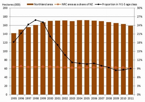
From the statistics presented in Figure 40 below it would appear that over the last five years there has been a 12,782ha or 7.4% reduction in the area of exotic forestry in Northland. The other significant change has been the decline in the percentage of exotic forest in the Year 1-5 age class since 1998. This shows through in the reduction in the planted area and will also start to show up in reduced volumes available for harvesting annually. These figures are consistent with the trend seen throughout the country.
Figure 40: Exotic forest in Northland
Where has our exotic forest gone?
While there were some small, private woodlots cleared early or as round-wood prior to the 2008 cut-off for "Kyoto forests" (the Kyoto Protocol is an international agreement linked to the United Nations Framework Convention on Climate Change) and not replanted, there are no obvious signs of major forest conversion in Northland, certainly not 12,782 hectares or 7.4% of the peak 2004 area as the statistics suggest. Some small woodlots in the north of the Far North have been cleared for farming and horticulture because transport costs to markets other than the Juken New Zealand Ltd. mill in Kaitāia or Port Marsden make tree growing unprofitable.
Small areas of pre-Kyoto forests, often very steep areas within the major forest blocks planted in the mid-1980s, have either not been harvested or will not be replanted because of the effort required and/or cost of recovering the logs exceeds the returns. Similarly, leaving wider riparian strips will have reduced the area replanted.
Some of the woodlots on free-draining sandy soils on the Aupōuri Peninsula have been logged and the land use converted to avocado orchards. Again, only relatively small areas are involved.
One possible explanation is that a combination of the need for more accurate accounting of forested land to satisfy climate change forestry policies and plans for and actual harvesting of the mid-1980s forests have refined the actual exotic forestry area statistics and more clearly identified areas of indigenous forest and wetland within the forestry blocks.
Horticulture
Figure 41: Contribution of crops to horticultural area

Source: Statistics NZ, Agricultural census 2007
While horticultural crops occupy only 1% of the agricultural land in Northland, the sector generates around 7% of the region's agricultural Gross Domestic Product (GDP) or 0.6% of the region's total GDP (see Table 2). The industry is a significant employer and contributes more per hectare to the social and economic well-being of the region than any other form of primary production. (Source: Infometrics Regional Database).
The major fruit crops grown in Northland are avocadoes, kiwifruit, citrus and wine grapes. A range of other sub-tropical and temperate fruit is also grown in the region.
Avocadoes are now the most widely planted crop (Figure 41), with the area in avocadoes increasing from less than 500ha in 2002 to greater than 1500ha in 2011. This compares with the second largest crop, kiwifruit, which has remained steady at around 500ha over the same period and citrus at around 300ha.
Kumara is the major vegetable crop grown in the region with around 900ha grown annually, or around 95% of the national crop.
What are the issues facing land use in Northland?
Protection of highly versatile soils
The most versatile soils, those which can be highly productive when used for horticulture, arable farming, pastoral farming or forestry, are assessed as Classes 1 and 2, with some Class 3, in the New Zealand Land Resource Inventory survey. They comprise the younger and more free-draining volcanic soils around Whāngārei, Kaikohe and Kerikeri, younger soils developed on sand around various parts of Northland, particularly on the Aupōuri Peninsula, and the more free-draining and least flood susceptible alluvial soils, particularly in the Northern Wairoa-Ruāwai area.
Land that has soil with a land use capability class of 1 or 2 makes up less than 3% of the total land area in Northland. These are the soils with the greatest value for horticultural production.
At the request of the Northland Horticultural Forum, reports were prepared by Enterprise Northland and Northland Regional Council (Jones D., and Cathcart R.: 2011) identifying the scope for horticultural growth in the region and the barriers to that growth. It was identified that significant growth in the horticultural industry could have a significant benefit to the regional economy. Among the major issues identified in the report were the loss of highly versatile soils to non-horticultural or non-agricultural uses and the importance of irrigation water to any growth in the industry.
The Northland Regional Council produced a database identifying highly versatile soils which was provided to the Far North, Whāngārei, and Kaipara district councils. Despite this, there has been little effective control over small lot and residential subdivision on highly versatile soils to date.
The recently Proposed Regional Policy Statement for Northland tested the issue of versatile soils through a section 32 Resource Management Act analysis. This analysis found that management of versatile soils was not a regionally significant issue in its own right and management of reverse sensitivity and incompatible land uses were a more obvious and pressing concern for primary production. The Proposed Regional Policy Statement therefore did not include specific provisions on protection of versatile soils. However, the issue can be addressed in district plans if there is evidence of a locally significant issue and a need for intervention. For example, Whāngārei District Council introduced an "Urban Transition Environment" Plan Change during the term of this State of the Environment review, with the aim being to better control development on the urban fringe. The same council is now working on a Rural Development Strategy which, among other issues, includes protecting versatile soils.
 Erosion-prone land on a hill-country farm.
Both of these two Whāngārei District Council initiatives are closely related: the first concerned with protecting the soil itself from unsustainable practice; and the second dealing with the offsite effects of unsustainable practices and uses on, primarily, water quality. There are a number of issues around land use that impact upon these objectives. Good land management practices will help to achieve both the above objectives.
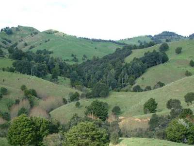
Erosion-prone Northland hill country
Greater than 60% of Northland's land area has a land use capability of six or greater, a proportion of which has moderate to severe erosion potential. Where this land is used for production purposes, whether it is farming or forestry, care must be taken to manage it with respect to its limitations.
Erosion from steep land not only reduces the productive capacity of the land due to the loss of fertile topsoil but also increases sedimentation of waterways downstream.
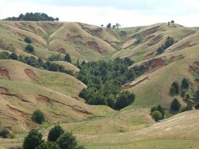 Severe erosion after an extreme rainfall event.
Severe erosion after extreme rainfall events
The intensification of dairy farms and the increase in intensive beef systems can result in increased environmental impacts if farm management is inadequate, or if the farm infrastructure is unable to cope with the increased stock numbers. Where more stock are carried per hectare, or stock are moved in larger mobs, there is an increased risk of pugging and compaction leading to an overall loss of soil drainage and biological activity. This will result in an increase in runoff during rain, which causes sheet erosion, washing fine sediment, nutrients and faecal material off grazing land into and contaminating streams as well as increasing the incidence of gully erosion.
Increased stocking rates also lead to greater volumes of nitrogen per hectare being concentrated in urine patches from where it is leached to streams via shallow groundwater or, on free-draining sandy and volcanic soils, to deeper groundwater.
While the reduction in phosphate fertiliser use on hill country soils helps to reduce phosphorus leaching to streams, it can also have unintended consequences on water quality. With the careful application of phosphorus fertilisers, a well-managed pasture can help to reduce surface forms of soil erosion on hill country and subsequent sediment and nutrient discharges to streams. However, a number of years with poor returns to sheep and beef farmers have resulted in a combination of reduced stock numbers and reduced fertiliser applications. Already there are signs of weakening pasture cover and increased weed growth. Surveys following major storm events have shown that land in an early stage of reversion, while in rank grass and light scrub, is the most at risk of slipping when compared with dense pasture, heavy scrub, exotic forest or native bush.
Exotic forestry
Forestry figures for Northland show both a decrease in the area in production forest and a decrease in the proportion of the forest in the 1–5 year age class. Any slowdown in the rate of afforestation of erosion-prone and marginal hill country land in Northland is of concern. The council and its predecessor the Northland Catchment Commission have consistently promoted afforestation of such land as a more sustainable form of land use, a means of slowing flood runoff and of controlling soil erosion.
A review in 2011 of current land use relative to land use capability identified further areas of land within (flood risk) priority river catchments which would benefit from afforestation as a means of reducing sediment load in rivers.
While large areas of hill country were planted in pine forests in the 1970s and 1980s, there are still significant areas that would benefit from afforestation, either for production or for carbon sequestration. This apparent reduction in the area of exotic forest is therefore of concern from both sustainable land management and regional economic development points of view.
Kiwifruit PSA
The recent identification of the kiwifruit pathogen in Northland is likely to have major implications for our kiwifruit industry. The gold variety widely grown in Northland is particularly susceptible to the bacterium. If the disease becomes widespread in the region, as it has in others, then there will be a loss in production as vines are either grafted over to more resistant varieties or removed altogether.
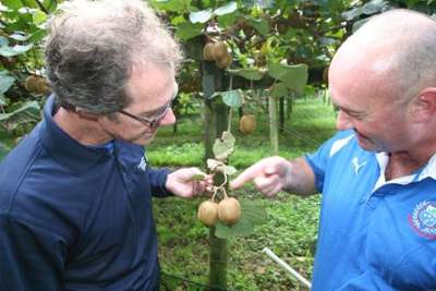 A Northland Regional Council Biosecurity staff member inspects kiwifruit for the PSA pathogen.
What is being done?
Under the operative Regional Policy Statement for Northland and the Regional Water and Soil Plan the council provided for a range of regulatory and non-regulatory mechanisms to achieve environmental outcomes.
Regulation
Because of the risk of accelerated erosion and generation of sediment, the Regional Water and Soil Plan contains rules relating to earthworks and vegetation clearance on erosion-prone land and within riparian management zones. However, earthworks and vegetation clearance under specified volumes and surface area limits are permitted activities subject to environmental performance standards.
Management of consented activities is the responsibility of the consent holder and is monitored by the council. Persons undertaking permitted activities are responsible for complying with the rules for those activities. The council receives and investigates complaints about land use activities and takes appropriate follow-up action where non-compliance with the relevant consent, if any, or permitted activity rules is found.
The Northland Forestry Guidelines, (adopted in 2012), is a set of guidelines developed between industry leaders and the Northland Regional Council. They are a guide to good practice when undertaking a variety of activities associated with the harvest of plantation forestry and aim to minimise the environmental effects of forestry operations.
Non-regulatory measures
Non-regulatory measures employed by the regional council include advice via its website www.nrc.govt.nz/land, pamphlets, and regular columns in newspapers. The council also promotes sustainable land management via its displays at the Northland Agricultural Field Days and Agricultural & Pastoral shows throughout the region. It partners primary sector groups such as Dairy NZ via its Focus Farms and local discussion groups, and Beef and Lamb New Zealand's Monitor Farm programme, in each case promoting the synergy between increased but sustainable production and reduction in environmental footprint.
The council and its Land Management team are heavily involved in the Ballance Farm Environment Awards, the council as a regional sponsor and its staff as judges and speakers at field days on the supreme winner's property each year. Again, the objective is to demonstrate that environmental stewardship is an integral part of any successful farming, forestry or horticultural venture.
Active advisory services provided by Land Management Advisors include answering specific requests for technical advice, making site visits, providing specific on-farm advice and, where requested, written advice. The most recent extension of these services has been the adoption of policy to prepare water quality improvement plans for landowners within catchments where water quality management is considered the highest priority.
The council recognises that the benefits of environmental management work can extend well beyond the boundaries of individual properties and can have benefits to future generations. It therefore makes grants totalling almost $500,000 annually to landowners from its Environment Fund. Typical activities include sharing the cost of fencing to exclude stock from streams and the coastal marine area, and using fences to protect indigenous wetlands, which act as filters of sediment, nutrients and faecal material. Funds are also allocated for soil conservation works such as planting poplars and willows and fencing bush on highly erodible sites, and for stabilising areas of foredune.
A proportion of this work has been jointly facilitated and funded by the Queen Elizabeth II National Trust and some projects have been of such high indigenous biodiversity value nationally that they have also received financial support from the Biodiversity Condition Fund.
Primary industry partners
The council's Land Management team works in partnership with the following primary industry sector groups:
• Beef and Lamb New Zealand through its Monitor Farm programme, providing detailed land resource inventory data on which development plans are based, and providing specialist input at farmer field days;
• Dairy NZ, through its Focus Farm programme, providing detailed land resource inventory data on which development plans are based, and providing specialist input at farmer field days, and by attending discussion group meetings;
• Northland Horticulture Forum by assisting in the preparation and promotion of a Northland horticulture growth strategy;
• Rural professionals, such as the NZ Institute of Primary Industry Management and the NZ Property Institute by facilitating or participating in workshops, field days and professional development opportunities;
• Ballance Agrinutrients by assisting with staff training, including joint staff training opportunities, and facilitating joint field days and workshops; and
• Northland Agricultural Forum, a rural professionals and farmer organisation that has promoted agricultural research in Northland.
Longer-term achievements
While records of length of fence subsidised, areas of bush fenced, and numbers of trees planted can be listed as outputs of the council's programmes, they are not a measure of actual environmental outcomes. The expected outcomes include regeneration of bush on retired land, improvement in pasture cover, and a reduction in the incidence of soil erosion and in the sediment load in streams. While some of these benefits can be realised within a few years, others take many years, even generations to achieve.
 A riparian margin fenced to exclude stock – fencing of riparian margins is one of the ways the council supports improved land management practices. Funding is available through the council's Environment Fund.
The region is only now seeing the real benefits of soil conservation programmes and changes of land use initiated in the 1960s and 1970s. The then Northland Catchment Commission and, in the Far North, the Ministry of Works and Development, working alongside the New Zealand Forest Service, promoted and supported afforestation of marginal, erosion-prone hill country. Government encouragement of forestry during the 1980s, at a time when pastoral farming was subject to economic squeeze, resulted in extensive forest plantings by forestry companies on this class of land.