Wetlands and biodiversity
Within this section…
A wetland is land that is covered in, or saturated by water for at least some of the time. Wetlands occur in areas where surface water collects or where underground water seeps through to the surface. They include swamps, bogs, marshes, gumlands, saltmarshes, mangroves and some river and lake stream edges.
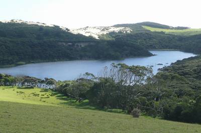
Photo: Dune lake at Te Paki
In the past wetlands in Northland covered around 258,451 hectares or 32 percent of the land area. Just 5.5% or 14,114 ha of the original wetland area remains. Some of the wetlands being lost in Northland are unique and therefore irreplaceable.
In 2009-2010 the Council initiated the Top Wetlands Project. This project identified and ranked more than 800 of Northland's remaining wetlands. The best and most irreplaceable of these have been prioritised for management and protection.
The next part of the project will involve contacting landowners, and then developing care standards – how to care for the different types of wetlands.
Biodiversity website
Biodiversity Northland is a collection of people from different agencies and groups who are involved with caring for Northland's natural values. The Northland Regional Council is managing the project and in 2009-2010 a map-based website of biodiversity information was created.
The website provides free web-based access to data on biodiversity and natural areas within Northland and includes information about:
- Reserve and covenant boundaries.
- Habitat survey information.
- Weed and pest sites.
- Landcare group locations.
You can visit the website at: