Land
Within this section…
Highly Versatile Soils
Highly versatile or ‘productive' soils are those on which we can grow a wide range of high value crops – tree crops, field crops and vegetables, grain crops, pasture, and forest trees – with no or few limitations. This definition includes soils that are already in production, and those with the potential for high productivity that may not currently be used.
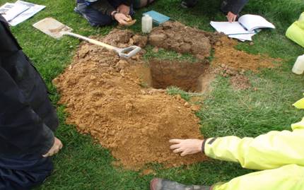
Photo: Regional Council staff learn how to conduct a visual soil assessment survey
The Regional Policy Statement (RPS) for Northland identifies the loss of these highly productive and versatile soils, particularly around Whangarei and Kerikeri, as an issue that needs addressing. The RPS recommends that we protect these soils from subdivision and land-use that may result in their permanent loss from production.
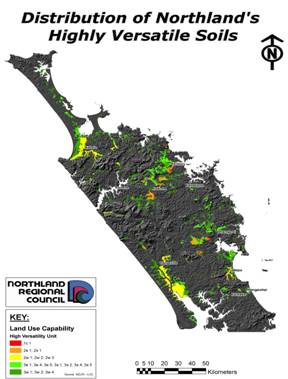
In 2008-09, the Council began a project to map all versatile soils in the region. These soils were chosen based on characteristics including underlying rock (geology), soil type, slope and wetness. The map (below) is now complete and can be used by both the Regional and District Councils to consider subdivision applications and land-use activities that may impact upon this valuable resource.
Erosion Prone Soils
The Council has been working on a soil conservation project aimed at finding out where soil erosion is occurring in the region, and what may be done to reduce the amount of soil lost from the land. The Erosion Prone Soils Project is closely associated with the Priority Rivers Project and the Council's work on water quality and estuary/harbour health. The initial focus of the project has been catchments included in the Priority Rivers Project.
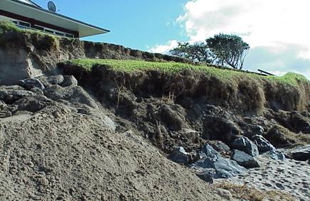
Photo: Mapping erosion prone soils in urban areas will identify land that is suitable for development or prone to slipping
The soil conservation project aims to identify where soil erosion is likely to occur by mapping land-use and land cover over soil type. This information is then checked on the ground to see where soil erosion is occurring. In addition, the project aims to identify sources of sediment in our rivers and streams other than from soil erosion. Once this information has been gathered, areas can be prioritised for soil conservation and sediment management initiatives.
Maps comparing current land use and vegetation cover with potential for erosion have now been completed for all of the larger Priority River Project catchments and field checking has been completed for the majority of these. These first two stages of the project will be completed over the next two months.
Most of the marginal farmland that, until the early 1980s, was suffering from serious erosion has now been converted to production forest or has reverted to native bush, reducing the loss of course sediment from this land. Improved pasture cover has also reduced the incidence of large-scale erosion on farmland. However, this cover is masking the loss of very fine sediment from the land and it is the increase in this sediment, along with the nutrients it carries, that is currently having the biggest impact on our waterways.
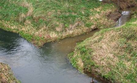
Photo: Fine sediment entering a stream from farmland
Once work is complete on mapping erosion prone soils and researching other sources of sediment in the priority river catchments, the Council can focus its efforts on priority areas and issues. Soil conservation initiatives can then be implemented in these areas to reduce the amount of sediment entering our water bodies.
Erosion Prone Soils Project - initial findings
· Natural events such as severe storms can cause widespread erosion, which contributes sediment to the river systems for the next 20-30 years
· There are currently very few areas where there is significant soil erosion due to land development or major land use changes
· However, research shows that there have been periods of extensive and very serious soil erosion in the past as a result of land-use activity
· Stream bank erosion is now the most widespread and significant source of course sediment in most of the Priority River Catchments
Why is sediment a problem?
· Sediment contaminates rivers, estuaries, harbours and inshore waters in Northland
· It can smother aquatic life and change the nature of river beds and estuaries, encouraging the growth of mangroves
· It reduces water quality and carries other contaminants, such as illness causing bacteria and nutrients
· It reduces the value of water bodies for activities such as gathering kaimoana and swimming
· It is very costly to remove sediment to make water suitable for drinking
· It reduces channel capacity and increases the risk of flooding
· It builds up the ground level on flood plains, increasing the frequency with which buildings, roads and other infrastructure flood
· It is costly to remove
Urban Land-use Capability
In addition to looking at erosion prone land in rural areas, the Council has been looking at land-use in urban areas to identify where people can build in order to avoid areas prone to flooding. To identify suitable areas for development, the Council looked at potential limitations on land such as how stable it is for building, how much erosion occurs on the land, how wet the land is and whether there would be room for infrastructure, such as soakage fields for septic tanks.
The ‘Urban Land-use Capability' of each area is assessed by looking at rock type, soil type, slope, terrain (ridge top, side slope, valley bottom, terrace, etc), erosion forms and severity, and any evidence of drainage or flooding problems. Areas mapped to date include Pawarenga, Panguru, Waihou Valley (Panguru), Taupo Bay, Tauranga Bay, Wainui, Mahinepua and Te Ngaere Bay.