Hydro-geological Investigations
Within this section…
Aquifers in Three Mile Bush, Maungakaramea and Kaikohe areas are recognised in the ‘Regional Water and Soil Plan for Northland' as "at-risk" aquifers with respect to groundwater demand and water quality issues. These three areas, highlighted on the "at risk aquifers" map in the specific groundwater investigations section, were prioritised for investigations either because of the lack of information on these areas and/or the large amount of development in the area.
Due to increased drilling activity and potential demand for groundwater in these areas, the Regional Council require better information to ensure the sustainable management of these groundwater resources. Given this hydro-geological investigations were carried out in these areas in 2005-06.The aim of the studies were to:
- Develop an understanding of the aquifer hydrogeology,
- Provide an estimation of the sustainable yield and
- Recommend future actions to enable the sustainable management of the groundwater resources.
An additional investigation is being carried out in the Awanui area to assess the effects of flowing artesian bores on the surrounding groundwater resource.
Three Mile Bush Groundwater Resources
The Three Mile Bush basalt aquifer is located directly west of Kamo, Whangarei. The study area comprises a 13.2 square kilometre basalt plateau at an elevation of approximately 230 metres above mean sea level. Groundwater from this aquifer is predominately used for horticultural irrigation, stock water and domestic water supply.
The main issues potentially affecting groundwater quality and quantity in the Three Mile Bush area are:
- Groundwater abstraction
- Bore construction and location
- Land use change
The study provided an assessment of the groundwater resources in the area, with the following recommendations:
- Further refinement of sustainable yield in the event of an increase in groundwater demand.
- Groundwater level survey to increase knowledge of groundwater flow.
- Increase in ongoing groundwater level monitoring in the northern part of the aquifer.
- Concurrent monitoring of spring and stream flow at a number of locations within the study area.
- Soil infiltration tests carried out to improve understanding of the groundwater recharge dynamics.
- Groundwater quality monitoring in other bores across the aquifer to identify potential groundwater quality issues.
Additional water level monitoring will commence in the northern part of the aquifer and the existing monitoring of groundwater level and quality, including anions, cations and bacteria, in the Three Mile Bush basalt aquifer will continue in the future.
Maungakaramea groundwater resources
The Maungakaramea basalt aquifer is located approximately 14 km southwest of Whangarei. The total study area is approximately 10.4 km2. Most of the study area is relatively flat, at an elevation of approximately 140 metres above mean sea level. The centre of the aquifer is a scoria cone, forming a "horseshoe" hill with an elevation of 225 metres above sea level.
Groundwater is generally used for horticultural irrigation, stock drinking, public and domestic water supply. The main potential groundwater issues are:
- Groundwater abstraction including effects on spring and stream flow
- Land use change
Based on the findings from the study the following recommendations were made:
- Survey groundwater bores and springs to obtain information on flow direction, recharge and sustainable yield estimates.
- Increase groundwater quality monitoring to evaluate the existing water quality and long term trends.
- Carry out soil infiltration tests to improve understanding of the groundwater recharge.
- Increase groundwater level monitoring (to daily).
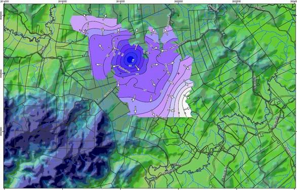
The map below shows the piezometric groundwater surface for the Maungakaramea cone. The arrows indicate the direction of groundwater flow and the contour lines are piezometric groundwater contours.
Monitoring of groundwater level and quality, including anions, cations and bacteria, in the Maungakaramea area will continue in the future. In the event of an increase in groundwater demand in the future, further of the above recommendations will be implemented.
Kaikohe groundwater resources
The Kaikohe aquifer underlies the Kaikohe Township. The aquifer comprises of the Kaikohe volcanic centre marked by a scoria cone at Memorial Hill, basalt flows extending to the south and south east of the cone splitting into two main lobes, and underlying older basaltic lava flows with no definable centre. The total aquifer area is 27 square kilometres.
The main issues potentially affecting groundwater quality and quantity in the Kaikohe area are:
- Groundwater abstraction (high allocation), including potential effects on spring/ stream flows
- Bore construction and location
- Land use change
Based on the preliminary findings in a draft report, the following recommendations were made:
- Carry out additional pump testing to establish extent of aquifer and interaction with springs and other aquifers.
- Gauge streams and springs, together with a groundwater level survey to estimate impacts of abstractions and design minimum flows to be determined.
- Conduct a bore and water use survey to refine sustainable yield of the aquifer.
- Delineate groundwater subcatchments.
- Develop a groundwater model.
Monitoring of groundwater level and quality, including anions, cations and bacterial, in the Kaikohe area will continue in the future. A further investigation is currently being carried out to determine recharge characteristics and spring/stream flow relationships in the Kaikohe area. The final report is due to be completed in December 2006.
Awanui Artesian Aquifer
The study area is centred on the Awanui Flats area directly north of Kaitaia. It has been estimated that as many as 500 bores have been historically drilled in to the artesian aquifer in the area. Many of these bores are now abandoned and are free flowing (uncapped). These bores naturally discharge groundwater into existing irrigation drains. It has been estimated that as much as 8,500 cubic metres of groundwater per day is flowing to waste in this area.
The aim of the study is to evaluate the effects of the free flowing bores on the surrounding resource the groundwater resources, and develop a groundwater model to predict the effects of potential management options including progressive bore closure.
Stage one of this study, was to review all existing information and develop a conceptual model of the aquifer. This stage will be completed and reported in April 2006. In the next financial year the information gained in stage one will be used to develop a detailed (computer) model of the aquifer. The detailed (computer) model will be used to assess the effects of different management options on the groundwater resource.