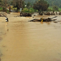
River flooding
River flooding poses the highest natural hazard risk to Northland due to the extensive development on floodplains and the region’s exposure to high intensity rainfall events.
In Te Ao Māori, the Māori world, rivers are seen as ancestors, and you can derive part of your identity by your connection with it. As proved by generations of Māori observation, those ancestors can meander across a landscape.
One way to explain this behaviour is through purakau – knowledge in story form. Māori might say, Beware the flicking tail of the taniwha (dangerous water spirit), to explain disaster risks in certain areas.
“If we actually listened to the way rivers behaved, and observed their natural fluctuations and observed seasonal things, and also looked out for the critters and things that live in rivers, in our conceptual design, those are the many voices of the river that are speaking to us”.
“Sometimes those voices are absent and sometimes those voices are silenced.” (Dan Hikuroa – University of Auckland).