January 2026 climate report
12 Feb 2026, 10:00 AM
Key take away from this report
January’s heavy rainfall events caused some significant localised flooding and land slips, particularly along the east coast strip from Ngunguru to Whangaruru, and has pushed Northland regions river flows, groundwater levels, and soil moisture levels considerably higher than normal for this time of year.
Summary
- Northland region averaged 232mm of rainfall in January, which is 299% of the long-term median, or normal expected.
- At the end of January Northland’s rainfall, groundwater levels, river flows, and soil moisture levels are almost all normal, to high, for this time of year.
- Current La Niña conditions are expected to weaken further, with about an 80% chance for ENSO-neutral (El Niño – Southern Oscillation) conditions to return by the end of April.
- As the season progresses, the risk for weather systems connected to the tropics and subtropics increases and could lead to significant rainfall events, especially for the North Island.
- ESNZ’s Climate Outlook for February to April 2026 indicates that rainfall, soil moisture, and river flows are most likely to be normal to above normal.
- There is currently a low risk of drought conditions developing in Northland over the next three months.
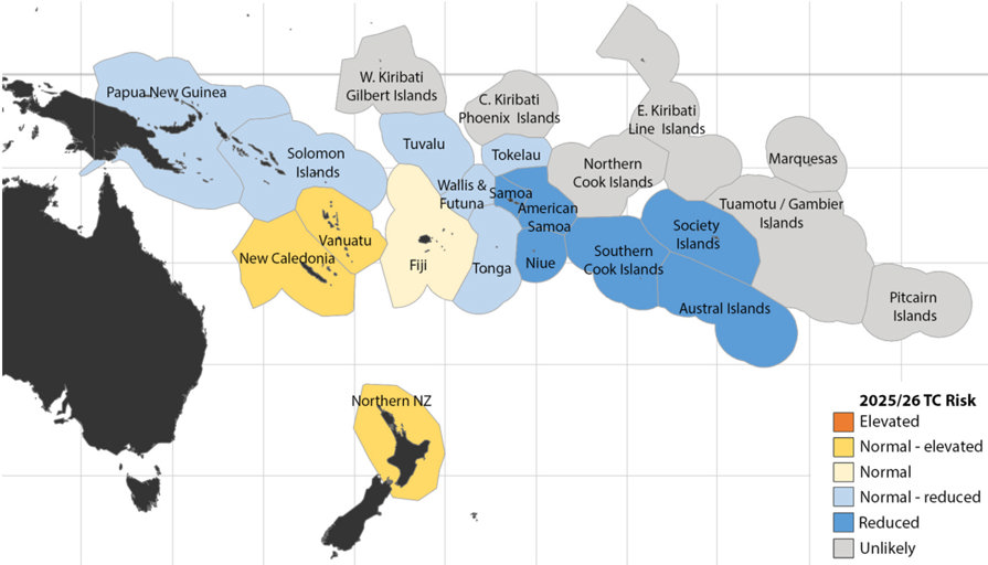
- On average at least one ex-tropical cyclone (TC) passes within 550km of New Zealand (NZ) each year.
- The Earth Sciences NZ/Metservice tropical cyclone outlook forecasts a normal to elevated risk for Northern NZ for the 2025-2026 season (November to April) which means that one to two ex-tropical cyclones are likely.
Rainfall
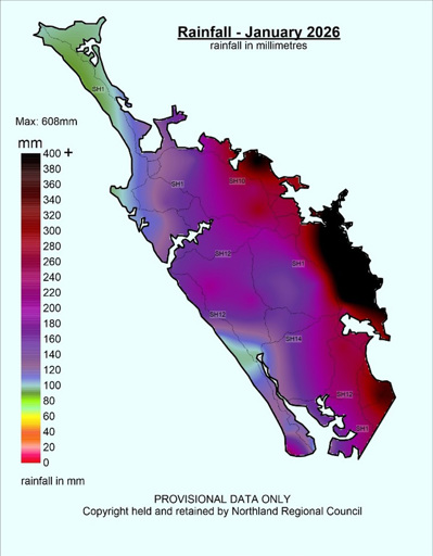
- Northland averaged 232 mm of rainfall across the region for January (Figure 1), which is 299% of the long-term median, or normal expected rainfall (Figure 2) for the month. Most of this rain came in a series of heavy rainfall events from 18 to 21 January, primarily focused along the east coast strip from Whangārei to Whangaroa.
- The highest rainfall total for the month was recorded at the Punaruku at Otetao Reti Marae, near Oakura, with 608mm, which is about 781% of normal expected.
- Other very high recording rainfall stations include: Ngunguru at Dugmores Rock with 511.5mm, 619%; Hatea at Glenbervie Forest HQ 461.5mm, 480%; Whakapara at Puhipuhi 466mm, 567%; Towai at Weta (north-east Kaeo catchment) 405.5mm, 407%; and Hakaru at Tara (inland Mangawhai) 358mm, 398% of normal expected rainfall for the month.
- The lowest rainfall for January was recorded at Poutō Point with 90.5mm, which is 199% of normal expected rainfall.
Figures 1 and 2: January 2026 rainfall distribution for Northland in mm, and in percentage of median. Showing an average of 232 mm (299% of expected) rainfall for the region.
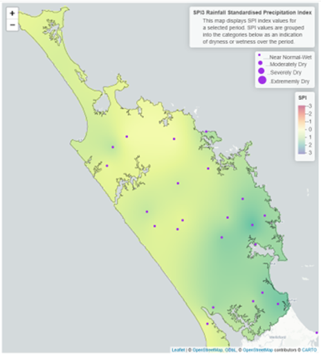
- Both the three-month and six-month Standardised Precipitation Index (SPI) (Figure 3 and 4) show that the region is “Near Normal – Wet”.
Figures 3 and 4: Standardised rainfall for Northland on a 3-month scale (Nov 2025 – Jan 2026) and a 6-month scale (August 2025 to Jan 2026).
River Flows
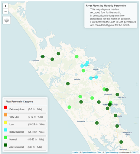
- January River flows for most of Northlands primary catchments were “Normal to Above Normal”, with the exception of rivers in the Bay of Islands area which averaged “Below Normal” flows for the month
Figure 5: River flows in Northland for January 2026.
Groundwater
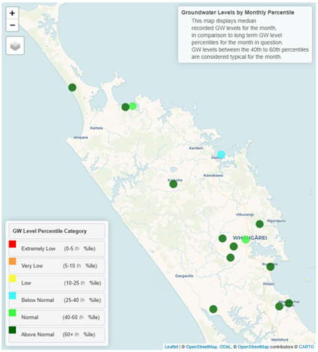
- Groundwater levels in most of Northland’s key monitored aquifers were “Above Normal” to “Normal” for January, while Russel groundwater levels were “Below Normal”.
Figure 6: Groundwater levels in Northland’s key monitored aquifers for January 2026
Soil moisture
Summary of modelled soil moisture data from Earth Sciences NZ
- The soil moisture deficit is calculated based on incoming daily rainfall (mm), outgoing daily potential evapotranspiration (mm), and a fixed available water capacity (the amount of water in the soil 'reservoir' that plants can use.
- January’s heavy rainfall lifted regional soil moisture levels for most of Northland well above the long-term average, and briefly above field capacity in eastern areas such as Kaikohe, Kerikeri, Whangārei and Warkworth.
- Soil moisture in Kaitaia remains below the long-term average.
Figure 7: Calculated daily soil moisture values at key areas around Northland, courtesy of ESNZ.
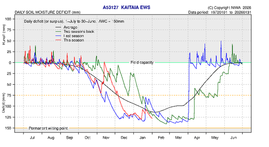 Figure 7b: Calculated daily soil moisture values at Kaikohe - January 2026
 Figure 7c: Calculated daily soil moisture values at Kerikeri - January 2026
 Figure 7d: Calculated daily soil moisture values at Dargaville - January 2026
 Figure 7e: Calculated daily soil moisture values at Whangārei- January 2026
 Figure 7f: Calculated daily soil moisture values at Warkworth - January 2026

Climate outlook for February to April 2026
Summary of climate forecasts from Earth Sciences NZ
- Current La Niña conditions are expected to weaken further, with about an 80% chance for ENSO-neutral (El Niño – Southern Oscillation) conditions to return by the end of April.
- As the season progresses, the risk for weather systems connected to the tropics and subtropics increases and could lead to significant rainfall events, especially for the North Island.
- Temperatures are most likely to be above average (50% chance).
- Rainfall totals are most likely to be above normal (50% chance). Weather systems linked to subtropics or tropics may bring heavy rainfall.
- Soil moisture levels are equally likely to be near normal (40% chance) or above normal (40% chance).
- River flows are about equally likely to be near normal (45% chance) or above normal (40% chance).
Table 1: Forecasted likelihood of above, near or below average climate conditions for Northland from February 2026 to April 2026, courtesy of ESNZ
(Expressed as % likelihood).
| Temperature | Rainfall | Soil moisture | River flows | |
| Above average | 50• | 50• | 40• | 40• |
| Near average | 30 | 40 | 40• | 45• |
| Below average | 20 | 10 | 20 | 15 |
Earth Sciences NZ Drought Index
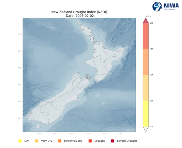
- The Drought Index is based on the Standardised Precipitation Index, the Soil Moisture Deficit, the Soil Moisture Deficit Anomaly, and the Potential Evapotranspiration Deficit, with a value less than 0.75 considered normal – wet.
- The ESNZ Drought Index for New Zealand indicates normal conditions in Northland at the start of February (Figure 8).
Figure 8: ESNZ Drought Index produced 2 February 2026.
Earth Science NZ’s Drought prediction Tool
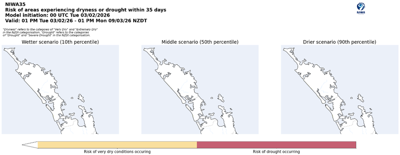
ESNZ’s drought prediction tool combines rainfall, soil moisture, and evapotranspiration to estimate the risk of meteorological drought, over the next 35 days.
- The model indicates that it is very unlikely that there will be any severe dryness in the 35 days (from 3 February 2026), as shown by all three scenarios in Figure 9.
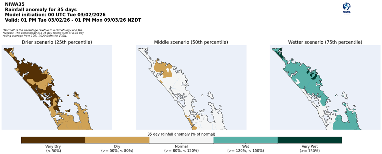
- The model also predicts for those 35 days that near normal to moderately dry rainfall conditions are most likely (50th percentile), but that dry to very dry (25th percentile), or wet to very wet conditions (75th percentile) are possible (Figure 10).
Figure 9: Drought risk assessment for Northland from ESNZ
Figure 10: Rainfall prediction for Northland from ESNZ 3 February 2026 – 9-March 2026
Northland Drought Risk Assessment
- The Drought Risk Assessment (Table 2) provides a visual summary of the current conditions of Northland’s rainfall, river flows, and groundwater levels and the current state of water resources. It also incorporates ESNZ’s Climate Outlook and Drought Index.
- At the end of January Northland’s rainfall, groundwater levels, river flows, and soil moisture levels are almost all normal to high for this time of year.
- There are some localised drier conditions such as soil moisture in Kaitaia and groundwater levels in Russell, which are both below average for this time of year.
- ESNZ’s Climate Outlook for February to April 2026 indicates that rainfall, soil moisture, and river flows are most likely to be normal to above normal.
- There is currently a low risk of drought conditions developing in Northland over the next three months.
Table 2: Drought Risk assessment matrix.
| Current conditions | Extreme | Very low | Low | Normal | High | Very high | Extreme |
| Rainfall | |||||||
| SPI maps | |||||||
| River flows | |||||||
| Groundwater levels | |||||||
| Soil moisture | |||||||
| Water resources current state | |||||||
| ESNZ 3-month outlook | |||||||
| ESNZ drought index |
Tropical Cyclone Outlook
Summary of NIWA and MetService Outlooks
- Late summer through early autumn is considered the peak of the tropical cyclone season.
- On average at least one ex-tropical cyclone (TC) passes within 550km of New Zealand (NZ) each year (Figure 11). This season the risk is considered normal to elevated until April.
- If an ex-TC tracks close to NZ, there is a near equal probability of it tracking to the east or west of the North Island. An ex-TC entering the NZ region could produce significant rainfall, severe winds, hazardous marine conditions and coastal damage.
Figure 11: ESNZ’s TC Risk levels for the 2025-26 Season

