November 2025 climate report
15 Dec 2025, 12:15 PM
Key take away from this report
High Spring rainfall in Northland has resulted in normal to high river flows, groundwater levels, and soil moisture levels for the region heading into summer.
Summary
- Northland region averaged 157% of normal expected rainfall for November, and 108% of normal expected rainfall for the three months of Spring.
- River flows groundwater and soil moisture levels range from “normal” to “above normal” for November.
- Moderate La Niña conditions are currently present in the tropical Pacific but could change to ENSO neutral by the end of summer.
- Air temperature is likely to be higher than normal and rainfall normal or above normal.
- There is currently a low risk of drought conditions developing in Northland over the next three months.
- On average at least one ex-tropical cyclone (TC) passes within 550km of New Zealand (NZ) each year.
- The Earth Sciences NZ/Metservice tropical cyclone outlook forecasts a normal to elevated risk for Northern NZ for the 2025-2026 season (November to April) which means that one to two ex-tropical cyclones are likely.
- There are currently no active cyclones tracked in the South Pacific.
Rainfall
- November, usually quite a dry month, was significantly wetter than average this year.
- Northland averaged 121mm of rainfall across the region for November (Figure 1), which is 151% of the long-term median, or normal expected rainfall (Figure 2).
- The highest rainfall total for the month was recorded at Waimamaku at Wekaweka Road in the South Hokianga with 276.5mm.
- Ōpua Wharf recorded the highest percentage of median with 251% of normal expected rainfall.
- Cape Rēinga recorded the lowest rainfall total for the month with 68mm.
- The lowest percentage of median was recorded at Opouteke at Brookvale, and Mangakahia at Twin Bridges, with 94% of normal expected rainfall.
Figures 1 and 2: November 2025 rainfall distribution for Northland in mm, and in percentage of median. Showing an average of 121 mm (157% of expected) rainfall for the region.


- The Northland region averaged 108% of median rainfall (normal expected) for the three months of Spring (Figure 3).
- Most sites recorded more than 100% of normal rainfall (13 out of 45 sites recorded between 74% and 100% of normal).
- The northern tip of Te Ika-a-Māui Cape Rēinga recorded only 74%, the lowest recorded percentage when compared to normal.
- The highest rainfall percentage for Spring was recorded at Waipao at Draffins Road, just north of Maungatapere, with 151% of normal expected rainfall.
- Both three-month and six-month Standardised Precipitation Index (SPI) (Figure 4 and 5) show that most of the region was “near normal – wet”.
Figure 3: Spring 2025 Percentage of median rainfall for Northland.

Figure 4 and 5: Standardised rainfall for Northland on a 3-month scale (Sep – Nov 2025) and a 6-month scale (June to Nov 2025).


River Flows
- In November River flows ranged from “normal” to “above normal” in all of Northland’s primary monitored catchments.
- These normal to high flows are reflective of the high rainfall recorded for the month, and through Spring.
Figure 6: River flows in Northland for November 2025.

Groundwater
- Groundwater levels in most of Northland’s key monitored aquifers were either “normal” or “above normal” in November.
- Only Puriri Park in Whangārei was “below normal.”
- The high groundwater levels are primarily due to high rainfall through winter and Spring.
Figure 7: Groundwater levels in Northland’s key monitored aquifers for November 2025.

Soil moisture
Summary of modelled soil moisture data from Earth Sciences NZ
- The soil moisture deficit is calculated based on incoming daily rainfall (mm), outgoing daily potential evapotranspiration (mm), and a fixed available water capacity (the amount of water in the soil 'reservoir' that plants can use.
- In November regional soil moisture levels for most of Northland were higher than the long-term average and this time last year.
- Kerikeri EWS soil moisture levels were about normal for this time of year.
- The high rainfall event in mid-November recharged soil moisture levels and caused runoff, most notable in Kaikohe and Warkworth.
Figure 8: Calculated daily soil moisture values at key areas around Northland, courtesy of ESNZ, data up to late November 2025.
 Figure 8: Calculated daily soil moisture values at Kaikohe - November 2025
 Figure 8: Calculated daily soil moisture values at Kerikeri - November 2025
 Figure 8: Calculated daily soil moisture values at Dargaville - November 2025
 Figure 8: Calculated daily soil moisture values at Warkworth - November 2025
 Figure 8: Calculated daily soil moisture values at Whangārei - November 2025

Climate Outlook for December 2025 to February 2026
Summary of climate forecasts from Earth Sciences NZ
- Moderate La Niña conditions are currently present in the tropical Pacific.
- However, a rapid weakening of La Niña conditions is expected during summer, with about a 50% chance for ENSO-neutral (El Niño – Southern Oscillation) conditions to return late in the season.
- Temperatures are highly likely to be above average (65% chance) (Figure 9).
- Rainfall totals are about equally likely to be near normal (40% chance) or above normal (35% chance). Rain events originating from, or having connections with, the sub-tropics and tropics may increase the chances for heavy rainfall events, especially during the second half of summer.
- Soil moisture levels and river flows are most likely to be near normal (40% chance) (Table 1).
- Tropical cyclone risk for the 2025-26 season is considered “normal-elevated” for northern Aotearoa with an expected 1-2 cyclones to hit our shores.
Figure 9: Forecast for rainfall and air temperature, courtesy of ESNZ, data ending November 2025.
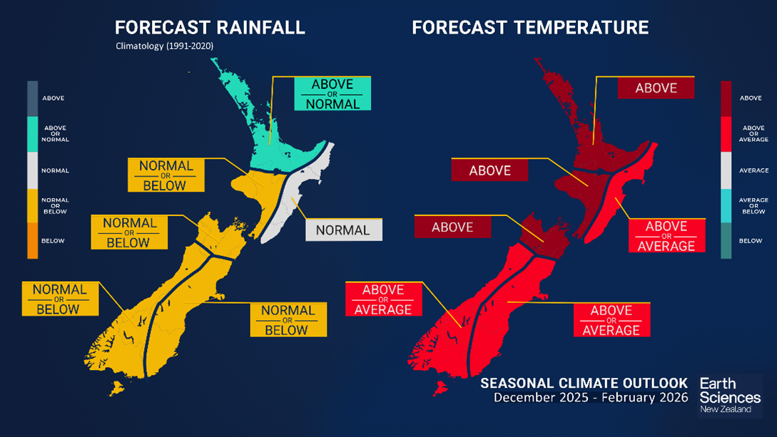
Figure 9: Forecast for rainfall and air temperature, courtesy of ESNZ, data ending November 2025.
Table 1: Forecasted likelihood of above, near or below average climate conditions for Northland from December 2025 to March 2026, courtesy of ESNZ.
(Expressed as % likelihood).
| Temperature | Rainfall | Soil moisture | River flows | |
| Above average | 65• | 35 | 25 | 15 |
| Near average | 30 | 40• | 40• | 40• |
| Below average | 5 | 25 | 35• | 35• |
Earth Sciences NZ Drought Index
- The Drought Index is based on the Standardised Precipitation Index, the Soil Moisture Deficit, the Soil Moisture Deficit Anomaly, and the Potential Evapotranspiration Deficit, with a value less than 0.75 considered normal – wet.
- The ESNZ Drought Index for New Zealand indicates normal conditions in Te Tai Tokorau at the end of November (Figures 10, and 11).
- Higher than average rainfall through Winter and Spring have reduced the likelihood of drought conditions developing.
Figure 10: ESNZ Drought Index produced 30 November 2025.

Figure 11: ESNZ drought index tracking for the Far North, Whangārei and Kaipara districts from January 2007 to November 2025.
Earth Science NZ’s Drought prediction Tool
ESNZ’s drought prediction tool combines rainfall, soil moisture, and evapotranspiration to estimate the risk of meteorological drought, over the next 35 days.
- According to the model it is very unlikely that there will be any severe dryness in the next 35 days (from 30 November 2025), as shown by all three scenarios in Figure 12.
- The model also predicts that over the next 35 days near normal rainfall conditions are most likely (50th percentile), but some dryness (25th percentile), or wet or very wet conditions (75th percentile) are possible (Figure 13).
Figure 12: Drought risk assessment for Northland from ESNZ from 30 November 2025.

Figure 13: Rainfall prediction for Northland from ESNZ from 30 November2025.

For more information visit the following sites:
Northland Drought Risk Assessment
- The Drought Risk Assessment (Table 2) provides a visual summary of the current conditions of Northland’s rainfall, river flows, and groundwater levels and the current state of water resources. It also incorporates ESNZ’s Climate Outlook and Drought Index.
- At the end of Spring, Northland’s rainfall, groundwater levels, river flows, and soil moisture levels are all normal to high for this time of year.
- ESNZ’s Climate Outlook for December 2025-February 2026 indicates that rainfall, soil moisture, and river flows are most likely to be close to normal.
- There is currently a low risk of drought conditions developing in Northland over the next three months.
Table 2: Drought Risk assessment matrix.
| Current conditions | Extreme | Very low | Low | Normal | High | Very high | Extreme |
| Rainfall | |||||||
| SPI maps | |||||||
| River flows | |||||||
| Groundwater levels | |||||||
| Soil moisture | |||||||
| Water resources current state | |||||||
| ESNZ 3-month outlook | |||||||
| ESNZ drought index |
Tropical Cyclone Outlook
Summary of NIWA and MetService Outlooks
- Late summer through early autumn is considered the peak of the tropical cyclone season.
- On average at least one ex-tropical cyclone (TC) passes within 550km of New Zealand (NZ) each year (Figure 14). This season the risk is considered normal to elevated until April.
- If an ex-TC tracks close to NZ, there is a near equal probability of it tracking to the east or west of the North Island. An ex-TC entering the NZ region could produce significant rainfall, severe winds, hazardous marine conditions and coastal damage.
- On 3 December 2025 there is no tropical cyclone detected in the Coral Sea or South Pacific.
Figure 14: ESNZ’s TC Risk levels for the 2025-26 Season
